Property Record
6842 N 45Th St, Omaha, NE 68152
This Property Is For Sale
NEARBY LISTINGS FOR SALE OR LEASE
Property Detail
6842 N 45Th St
Omaha-Council Bluffs, NE-IA
Lands
4165-0002-02
Douglas
Sfr
Nebraska
X
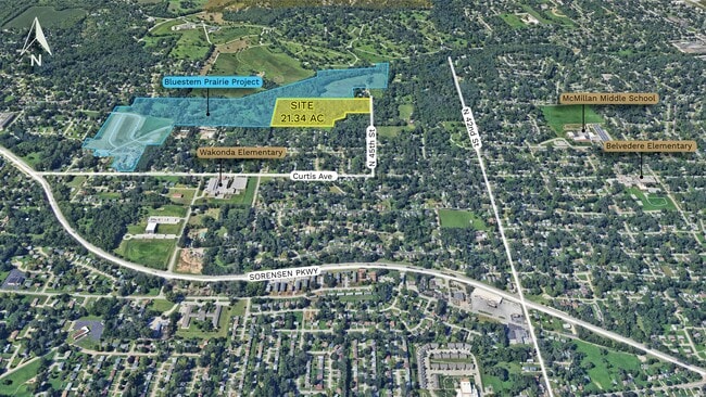
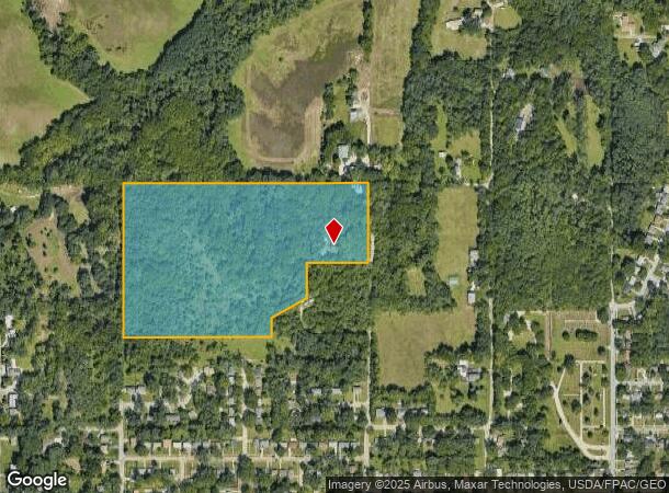
21.34 AC
31055C0228H
Northeast Omaha
1,428 SF
Omaha/Council Bluffs
DEMOGRAPHICS near 6842 N 45Th St
1 Mile
3 Mile
5 Mile
2024 Total Population
9,749
80,263
184,961
2029 Population
9,930
82,713
190,503
Pop Growth 2024-2029
+ 1.86%
+ 3.05%
+ 3.00%
Average Age
37
37
37
2024 Total Households
3,482
29,850
74,391
HH Growth 2024-2029
+ 1.87%
+ 3.18%
+ 3.22%
Median Household Inc
$43,734
$44,038
$52,291
Avg Household Size
2.70
2.60
2.30
2024 Avg HH Vehicles
2.00
2.00
2.00
Median Home Value
$104,255
$139,723
$170,722
Median Year Built
1960
1958
1961
Nearby Places
- Restaurants
- Banks
- Shops
- Fitness
- Groceries
PUBLIC TRANSPORTATION
COMMUTER RAIL
Omaha Amtrak Station (California Zephyr - Amtrak)
DRIVE
WALK
Distance
Omaha Amtrak Station (California Zephyr - Amtrak)
13 min
7.1 mi
Omaha Amtrak Station (California Zephyr - Amtrak)
DRIVE
WALK
Distance
Omaha Amtrak Station (California Zephyr - Amtrak)
14 min
7.3 mi
AIRPORT
Eppley Airfield
DRIVE
WALK
Distance
Eppley Airfield
16 min
7.3 mi
Freight Ports
Tulsa Port Of Catoosa
DRIVE
WALK
Distance
Tulsa Port Of Catoosa
470 min
423.5 mi
Nearby Properties
Address
Land Use
TOTAL SIZE
Lot Size
Zoning
Address
Land Use
TOTAL SIZE
Lot Size
Zoning
141,816 SF
24.91 AC
Address
Land Use
TOTAL SIZE
Lot Size
Zoning
125,945 SF
Address
Land Use
TOTAL SIZE
Lot Size
Zoning
540,097 SF
20.98 AC
GI
Address
Land Use
TOTAL SIZE
Lot Size
Zoning
172,424 SF
2.88 AC
R7
Address
Land Use
TOTAL SIZE
Lot Size
Zoning
200,000 SF
11.49 AC
GI
Address
Land Use
TOTAL SIZE
Lot Size
Zoning
164,320 SF
6.88 AC
Address
Land Use
TOTAL SIZE
Lot Size
Zoning
146,846 SF
8.67 AC
Address
Land Use
TOTAL SIZE
Lot Size
Zoning
109,605 SF
1.05 AC
Address
Land Use
TOTAL SIZE
Lot Size
Zoning
142,451 SF
19.14 AC
Address
Land Use
TOTAL SIZE
Lot Size
Zoning
92,817 SF
5.68 AC
GO
Address
Land Use
TOTAL SIZE
Lot Size
Zoning
178,896 SF
16.92 AC
Address
Land Use
TOTAL SIZE
Lot Size
Zoning
80,668 SF
0.70 AC
GI
Address
Land Use
TOTAL SIZE
Lot Size
Zoning
178,314 SF
28.08 AC
Address
Land Use
TOTAL SIZE
Lot Size
Zoning
113,216 SF
12.93 AC
GI
Address
Land Use
TOTAL SIZE
Lot Size
Zoning
126,372 SF
11.81 AC
Address
Land Use
TOTAL SIZE
Lot Size
Zoning
61,867 SF
8.46 AC
MU
Address
Land Use
TOTAL SIZE
Lot Size
Zoning
111,770 SF
2.65 AC
Address
Land Use
TOTAL SIZE
Lot Size
Zoning
97,422 SF
4.06 AC
Address
Land Use
TOTAL SIZE
Lot Size
Zoning
120,215 SF
12.49 AC
MU
Address
Land Use
TOTAL SIZE
Lot Size
Zoning
383,283 SF
11.94 AC
GI
Address
Land Use
TOTAL SIZE
Lot Size
Zoning
74,015 SF
27.11 AC
DR
Address
Land Use
TOTAL SIZE
Lot Size
Zoning
51,129 SF
10.18 AC
DR
Address
Land Use
TOTAL SIZE
Lot Size
Zoning
801,643 SF
1.72 AC
Address
Land Use
TOTAL SIZE
Lot Size
Zoning
246,595 SF
17.53 AC
HI
Address
Land Use
TOTAL SIZE
Lot Size
Zoning
141,156 SF
5.47 AC
R8
Address
Land Use
TOTAL SIZE
Lot Size
Zoning
97,368 SF
5.51 AC
GI
Address
Land Use
TOTAL SIZE
Lot Size
Zoning
62,310 SF
3.44 AC
Address
Land Use
TOTAL SIZE
Lot Size
Zoning
92,214 SF
4.67 AC
GI
Address
Land Use
TOTAL SIZE
Lot Size
Zoning
28,084 SF
5.22 AC
Address
Land Use
TOTAL SIZE
Lot Size
Zoning
86,046 SF
5 AC
The World's #1 Commercial Real Estate Marketplace
Connect with us
© 2025 CoStar Group
The information above has been obtained from sources believed reliable. While we do not doubt its accuracy we have not verified it and make no guarantee, warranty or representation about it. It is your responsibility to independently confirm its accuracy and completeness. Any projections, opinions, assumptions, or estimates used are for example only and do not represent the current or future performance of the property. The value of this transaction to you depends on tax and other factors which should be evaluated by your tax, financial, and legal advisors. You and your advisors should conduct a careful, independent investigation of the property to determine to your satisfaction the suitability of the property for your needs.