Property Record
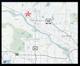
6845 Highway 10 Nw, Anoka, MN 55303


NEARBY LISTINGS FOR SALE OR LEASE
Property Detail
6845 Highway 10 Nw
Minneapolis-St. Paul-Bloomington, MN-WI
Auditors Subdivision No 31
34-32-25-21-0001
LOT 3 AUDITORS SUBDIVISION NO 31 DESC AS FOL: BEG AT SW COR OF SD LOT, TH SELY ALG SLY LINE OF SD LOT 450 FT, TH N PRLL/W W LINE THEREOF 385.04 FT TO N LINE OF SD LOT, TH NWLY ALG SD NLY LINE 447.09 FT TO NW COR THEREOF, TH S ALG W LINE OF SD LOT TO
Commercialnec
Anoka
X
Minnesota
27053C0052F
3
2025
4 AC
2025
North Central
050228
Minneapolis/St Paul
16,820 SF
DEMOGRAPHICS near 6845 Highway 10 Nw
1 Mile
3 Mile
5 Mile
2024 Total Population
3,354
36,552
84,216
2029 Population
3,469
38,014
86,926
Pop Growth 2024-2029
+ 3.43%
+ 4.00%
+ 3.22%
Average Age
37
39
40
2024 Total Households
1,229
13,485
31,640
HH Growth 2024-2029
+ 3.50%
+ 4.03%
+ 3.22%
Median Household Inc
$85,568
$94,447
$93,258
Avg Household Size
2.70
2.70
2.60
2024 Avg HH Vehicles
2.00
2.00
2.00
Median Home Value
$287,001
$312,270
$320,603
Median Year Built
1996
1993
1989
Nearby Places
Map Layers
Map Styles
 Street
 Aerial
- Restaurants
- Banks
- Shops
- Fitness
- Groceries
PUBLIC TRANSPORTATION
COMMUTER RAIL
Ramsey Station & Platform (Northstar Commuter Rail - Metro Transit)
DRIVE
WALK
Distance
Ramsey Station & Platform (Northstar Commuter Rail - Metro Transit)
3 min
1.5 mi
Anoka Station (Northstar Corridor - Northstar Commuter Rail)
DRIVE
WALK
Distance
Anoka Station (Northstar Corridor - Northstar Commuter Rail)
8 min
4.7 mi
AIRPORT
Minneapolis-St Paul International/Wold-Chamberlain
DRIVE
WALK
Distance
Minneapolis-St Paul International/Wold-Chamberlain
50 min
36.7 mi
Freight Ports
Port Milwaukee
DRIVE
WALK
Distance
Port Milwaukee
396 min
358.9 mi
SALE & LEASE HISTORY
LISTING DATE
SALE/LEASE

Sep 24, 2016
For Sale
Nov 21, 2016
For Sale
Jun 20, 2018
For Lease
Aug 09, 2017
For Sale
Nearby Properties
Address
Land Use
TOTAL SIZE
Lot Size
Zoning
Address
Land Use
TOTAL SIZE
Lot Size
Zoning
3,491 SF
3.03 AC
Address
Land Use
TOTAL SIZE
Lot Size
Zoning
363,449 SF
82.99 AC
R-1
Address
Land Use
TOTAL SIZE
Lot Size
Zoning
68,362 SF
Address
Land Use
TOTAL SIZE
Lot Size
Zoning
382,508 SF
Address
Land Use
TOTAL SIZE
Lot Size
Zoning
229,457 SF
16.04 AC
Address
Land Use
TOTAL SIZE
Lot Size
Zoning
343,297 SF
25.42 AC
M-1
Address
Land Use
TOTAL SIZE
Lot Size
Zoning
153,964 SF
3.90 AC
Address
Land Use
TOTAL SIZE
Lot Size
Zoning
140,288 SF
5.12 AC
Address
Land Use
TOTAL SIZE
Lot Size
Zoning
300,547 SF
19.21 AC
Address
Land Use
TOTAL SIZE
Lot Size
Zoning
298,148 SF
17.70 AC
M-1
Address
Land Use
TOTAL SIZE
Lot Size
Zoning
319,019 SF
17.14 AC
Address
Land Use
TOTAL SIZE
Lot Size
Zoning
147,000 SF
Address
Land Use
TOTAL SIZE
Lot Size
Zoning
147,000 SF
Address
Land Use
TOTAL SIZE
Lot Size
Zoning
114,281 SF
3.19 AC
PRD-4
Address
Land Use
TOTAL SIZE
Lot Size
Zoning
319,664 SF
19.62 AC
M-1
Address
Land Use
TOTAL SIZE
Lot Size
Zoning
436,117 SF
17.75 AC
M-1
Address
Land Use
TOTAL SIZE
Lot Size
Zoning
190,285 SF
12.98 AC
Address
Land Use
TOTAL SIZE
Lot Size
Zoning
Address
Land Use
TOTAL SIZE
Lot Size
Zoning
201,859 SF
9.21 AC
Address
Land Use
TOTAL SIZE
Lot Size
Zoning
100 SF
5.42 AC
R-2
Address
Land Use
TOTAL SIZE
Lot Size
Zoning
60,588 SF
4.56 AC
Address
Land Use
TOTAL SIZE
Lot Size
Zoning
111,300 SF
Address
Land Use
TOTAL SIZE
Lot Size
Zoning
Address
Land Use
TOTAL SIZE
Lot Size
Zoning
83,357 SF
5.35 AC
Address
Land Use
TOTAL SIZE
Lot Size
Zoning
98,933 SF
9.61 AC
R-2
Address
Land Use
TOTAL SIZE
Lot Size
Zoning
172,332 SF
Address
Land Use
TOTAL SIZE
Lot Size
Zoning
98,770 SF
5.48 AC
R-2
Address
Land Use
TOTAL SIZE
Lot Size
Zoning
75,262 SF
6.54 AC
Address
Land Use
TOTAL SIZE
Lot Size
Zoning
84,201 SF
1.87 AC
Address
Land Use
TOTAL SIZE
Lot Size
Zoning
151,524 SF
18.10 AC
The World's #1 Commercial Real Estate Marketplace
Connect with us
© 2025 CoStar Group
The information above has been obtained from sources believed reliable. While we do not doubt its accuracy we have not verified it and make no guarantee, warranty or representation about it. It is your responsibility to independently confirm its accuracy and completeness. Any projections, opinions, assumptions, or estimates used are for example only and do not represent the current or future performance of the property. The value of this transaction to you depends on tax and other factors which should be evaluated by your tax, financial, and legal advisors. You and your advisors should conduct a careful, independent investigation of the property to determine to your satisfaction the suitability of the property for your needs.