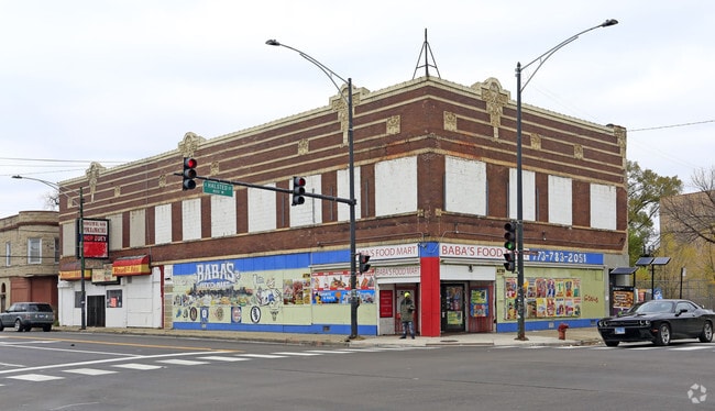
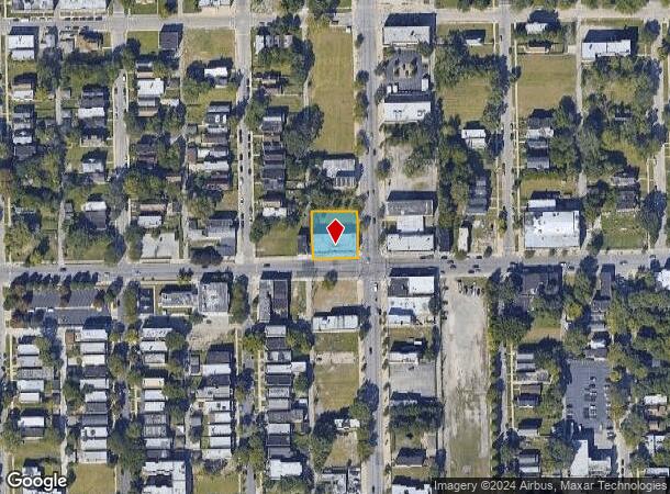
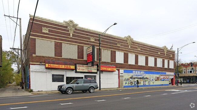
Property Record
6848 S Halsted St, Chicago, IL 60621
NEARBY LISTINGS FOR SALE OR LEASE
Property Detail
6848 S Halsted St
Chicago-Naperville-Elgin, IL-IN
Benedicts Sub
20-20-415-036-0000
(BENEDICTS) SUB OF NE SE SEC 20-38-14
Storebuilding
Cook
X
Illinois
17031C0520J
20,22
2023
0.34 AC
2025
South Chicago
680900
Chicago
11,750 SF
DEMOGRAPHICS near 6848 S Halsted St
1 Mile
3 Mile
5 Mile
2024 Total Population
31,252
279,441
742,341
2029 Population
30,414
267,483
709,358
Pop Growth 2024-2029
(2.68%)
(4.28%)
(4.44%)
Average Age
38
38
39
2024 Total Households
11,993
105,381
282,110
HH Growth 2024-2029
(2.99%)
(4.50%)
(4.49%)
Median Household Inc
$24,437
$33,475
$44,530
Avg Household Size
2.40
2.50
2.50
2024 Avg HH Vehicles
1.00
1.00
1.00
Median Home Value
$98,202
$167,634
$208,090
Median Year Built
1948
1948
1949
Nearby Places
Map Layers
Map Styles
 Street
 Aerial
- Restaurants
- Banks
- Shops
- Fitness
- Groceries
PUBLIC TRANSPORTATION
TRANSIT/SUBWAY
Halsted Station (Green Line) (Green Line - Chicago Transit Authority "L" Trains (The "L"))
DRIVE
WALK
Distance
Halsted Station (Green Line) (Green Line - Chicago Transit Authority "L" Trains (The "L"))
2 min
15 min
0.7 mi
69th Street Station (Red Line - Chicago Transit Authority "L" Trains (The "L"))
DRIVE
WALK
Distance
69th Street Station (Red Line - Chicago Transit Authority "L" Trains (The "L"))
6 min
20 min
1.0 mi
COMMUTER RAIL
Gresham Station (Rock Island District Line - Northeast Illinois Regional Commuter Railroad (Metra))
DRIVE
WALK
Distance
Gresham Station (Rock Island District Line - Northeast Illinois Regional Commuter Railroad (Metra))
5 min
2.3 mi
75th Street (Grand Crossing) Station (Metra Electric Line - Northeast Illinois Regional Commuter Railroad (Metra))
DRIVE
WALK
Distance
75th Street (Grand Crossing) Station (Metra Electric Line - Northeast Illinois Regional Commuter Railroad (Metra))
7 min
3.2 mi
AIRPORT
Chicago Midway International
DRIVE
WALK
Distance
Chicago Midway International
14 min
6.6 mi
Chicago O'Hare International
DRIVE
WALK
Distance
Chicago O'Hare International
64 min
29.1 mi
SALE & LEASE HISTORY
LISTING DATE
SALE/LEASE

Jul 07, 2022
For Lease
Jul 07, 2022
For Sale
Nearby Properties
Address
Land Use
TOTAL SIZE
Lot Size
Zoning
Address
Land Use
TOTAL SIZE
Lot Size
Zoning
10.73 AC
PD 1243
Address
Land Use
TOTAL SIZE
Lot Size
Zoning
134,800 SF
2.53 AC
PD 1273
Address
Land Use
TOTAL SIZE
Lot Size
Zoning
159,300 SF
13.36 AC
PD 425
Address
Land Use
TOTAL SIZE
Lot Size
Zoning
0.91 AC
PD 1177
Address
Land Use
TOTAL SIZE
Lot Size
Zoning
87,830 SF
0.76 AC
B1-1
Address
Land Use
TOTAL SIZE
Lot Size
Zoning
7,200 SF
0.22 AC
B3-3
Address
Land Use
TOTAL SIZE
Lot Size
Zoning
PD 43
Address
Land Use
TOTAL SIZE
Lot Size
Zoning
Address
Land Use
TOTAL SIZE
Lot Size
Zoning
1.65 AC
B2-3
Address
Land Use
TOTAL SIZE
Lot Size
Zoning
PD 43
Address
Land Use
TOTAL SIZE
Lot Size
Zoning
78,000 SF
0.62 AC
RM-5
Address
Land Use
TOTAL SIZE
Lot Size
Zoning
36,365 SF
Address
Land Use
TOTAL SIZE
Lot Size
Zoning
7.47 AC
RT-4
Address
Land Use
TOTAL SIZE
Lot Size
Zoning
166,292 SF
5.95 AC
PMD13
Address
Land Use
TOTAL SIZE
Lot Size
Zoning
13,700 SF
0.33 AC
B3-2
Address
Land Use
TOTAL SIZE
Lot Size
Zoning
141,165 SF
7.82 AC
PD 966
Address
Land Use
TOTAL SIZE
Lot Size
Zoning
0.18 AC
PD 43
Address
Land Use
TOTAL SIZE
Lot Size
Zoning
15,052 SF
1.03 AC
PQ
Address
Land Use
TOTAL SIZE
Lot Size
Zoning
65,186 SF
10.47 AC
PD 566
Address
Land Use
TOTAL SIZE
Lot Size
Zoning
101,294 SF
8.10 AC
B3-1
Address
Land Use
TOTAL SIZE
Lot Size
Zoning
145,291 SF
7.85 AC
B3-2
Address
Land Use
TOTAL SIZE
Lot Size
Zoning
111,198 SF
10.60 AC
PD 566
Address
Land Use
TOTAL SIZE
Lot Size
Zoning
743,663 SF
7.14 AC
RT-4
Address
Land Use
TOTAL SIZE
Lot Size
Zoning
2.51 AC
RT-4,PD 12
Address
Land Use
TOTAL SIZE
Lot Size
Zoning
15,600 SF
0.18 AC
C2-1
Address
Land Use
TOTAL SIZE
Lot Size
Zoning
0.54 AC
RS-3
Address
Land Use
TOTAL SIZE
Lot Size
Zoning
10,500 SF
0.75 AC
C2-3
Address
Land Use
TOTAL SIZE
Lot Size
Zoning
0.39 AC
C2-3
Address
Land Use
TOTAL SIZE
Lot Size
Zoning
0.39 AC
C2-3
Address
Land Use
TOTAL SIZE
Lot Size
Zoning
0.37 AC
C2-3
The World's #1 Commercial Real Estate Marketplace
Connect with us
© 2026 CoStar Group
The information above has been obtained from sources believed reliable. While we do not doubt its accuracy we have not verified it and make no guarantee, warranty or representation about it. It is your responsibility to independently confirm its accuracy and completeness. Any projections, opinions, assumptions, or estimates used are for example only and do not represent the current or future performance of the property. The value of this transaction to you depends on tax and other factors which should be evaluated by your tax, financial, and legal advisors. You and your advisors should conduct a careful, independent investigation of the property to determine to your satisfaction the suitability of the property for your needs.