Property Record
685 Highway 3 N, Hampton, GA 30228
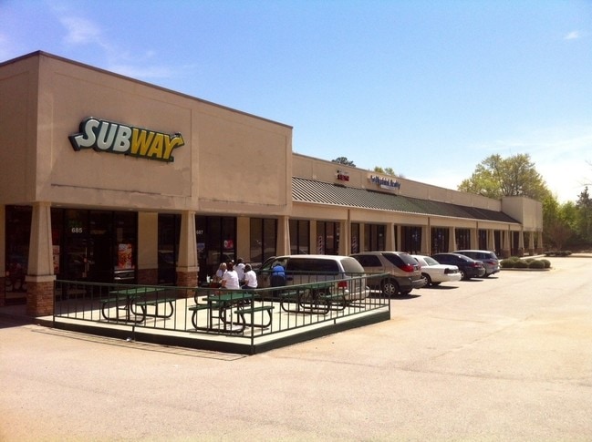

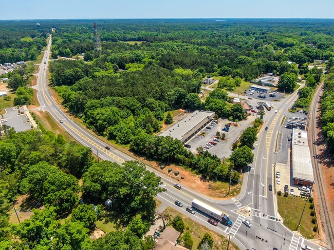

Property Detail
685 Highway 3 N
0019-02-022-005
LLOT: 185 LDIST:6
Stripcommercialcenter
Henry
C2
Georgia
B and X Area of moderate flood hazard, usually the area between the limits of the 100-year and 500-year floods.
185
2025
3.23 AC
2025
W Henry/Spalding
070503
Atlanta
14,101 SF
Atlanta-Sandy Springs-Roswell, GA
NEARBY LISTINGS FOR SALE OR LEASE
DEMOGRAPHICS near 685 Highway 3 N
1 mile
3 mile
5 mile
2025 Total Population
3,224
30,617
66,612
2030 Population
3,405
32,361
69,785
Pop Growth 2025-2030
+ 5.61%
+ 5.70%
+ 4.76%
Average Age
39
37
38
2025 Total Households
1,071
9,813
22,038
HH Growth 2025-2030
+ 5.79%
+ 5.74%
+ 4.86%
Median Household Inc
$72,518
$75,663
$79,864
Avg Household Size
3.00
2.90
2.90
2025 Avg HH Vehicles
2.00
2.00
2.00
Median Home Value
$318,163
$321,782
$318,173
Median Year Built
2002
2004
2003
Nearby Places
Map Layers
Map Styles
 Street
 Aerial
Layers
 Traffic
 Biking
Places
Listings with unknown addresses are not visible on the map
- Restaurants
- Banks
- Shops
- Fitness
- Groceries
PUBLIC TRANSPORTATION
AIRPORT
Hartsfield - Jackson Atlanta International
Drive
Walk
Distance
Hartsfield - Jackson Atlanta International
32 min
19.7 mi
Freight Ports
Georgia Ports - Savannah
Drive
Walk
Distance
Georgia Ports - Savannah
253 min
226.3 mi
SALE & LEASE HISTORY
LISTING DATE
SALE/LEASE

Sep 25, 2016
For Lease
Sep 24, 2016
For Sale
Sep 01, 2022
For Lease
Jun 01, 2022
For Sale
Nearby Properties
Address
Land Use
TOTAL SIZE
Lot Size
Zoning
Address
Land Use
TOTAL SIZE
Lot Size
Zoning
269,130 SF
15.78 AC
C
Address
Land Use
TOTAL SIZE
Lot Size
Zoning
250 SF
23.09 AC
C
Address
Land Use
TOTAL SIZE
Lot Size
Zoning
224 SF
20 AC
C
Address
Land Use
TOTAL SIZE
Lot Size
Zoning
194,270 SF
24.27 AC
C
Address
Land Use
TOTAL SIZE
Lot Size
Zoning
54,499 SF
10.18 AC
GB
Address
Land Use
TOTAL SIZE
Lot Size
Zoning
42,762 SF
6 AC
C
Address
Land Use
TOTAL SIZE
Lot Size
Zoning
289 SF
50.20 AC
C
Address
Land Use
TOTAL SIZE
Lot Size
Zoning
350 SF
130.46 AC
C1
Address
Land Use
TOTAL SIZE
Lot Size
Zoning
26,297 SF
77 AC
AG
Address
Land Use
TOTAL SIZE
Lot Size
Zoning
47,057 SF
6.83 AC
C
Address
Land Use
TOTAL SIZE
Lot Size
Zoning
9.19 AC
C
Address
Land Use
TOTAL SIZE
Lot Size
Zoning
188,814 SF
54.12 AC
RA
Address
Land Use
TOTAL SIZE
Lot Size
Zoning
147,861 SF
36.79 AC
M1
Address
Land Use
TOTAL SIZE
Lot Size
Zoning
75,588 SF
42.52 AC
Address
Land Use
TOTAL SIZE
Lot Size
Zoning
1,826 SF
169.71 AC
C
Address
Land Use
TOTAL SIZE
Lot Size
Zoning
3,648 SF
533.15 AC
AG
Address
Land Use
TOTAL SIZE
Lot Size
Zoning
8.44 AC
C
Address
Land Use
TOTAL SIZE
Lot Size
Zoning
402.93 AC
Address
Land Use
TOTAL SIZE
Lot Size
Zoning
41,568 SF
29.31 AC
M2
Address
Land Use
TOTAL SIZE
Lot Size
Zoning
1,404 SF
62.12 AC
RMH
Address
Land Use
TOTAL SIZE
Lot Size
Zoning
80,166 SF
95.23 AC
HI
Address
Land Use
TOTAL SIZE
Lot Size
Zoning
24,540 SF
26 AC
C1
Address
Land Use
TOTAL SIZE
Lot Size
Zoning
26.60 AC
C
Address
Land Use
TOTAL SIZE
Lot Size
Zoning
371,928 SF
10.16 AC
M1
Address
Land Use
TOTAL SIZE
Lot Size
Zoning
11,126 SF
2.89 AC
C
Address
Land Use
TOTAL SIZE
Lot Size
Zoning
28,554 SF
8.13 AC
C
Address
Land Use
TOTAL SIZE
Lot Size
Zoning
183,000 SF
6.40 AC
M2
Address
Land Use
TOTAL SIZE
Lot Size
Zoning
68,010 SF
8 AC
M1
Address
Land Use
TOTAL SIZE
Lot Size
Zoning
11,608 SF
1.89 AC
C
Address
Land Use
TOTAL SIZE
Lot Size
Zoning
4,252 SF
1 AC
GB
The World's #1 Commercial Real Estate Marketplace
Connect with us
© 2026 CoStar Group
The information above has been obtained from sources believed reliable. While we do not doubt its accuracy we have not verified it and make no guarantee, warranty or representation about it. It is your responsibility to independently confirm its accuracy and completeness. Any projections, opinions, assumptions, or estimates used are for example only and do not represent the current or future performance of the property. The value of this transaction to you depends on tax and other factors which should be evaluated by your tax, financial, and legal advisors. You and your advisors should conduct a careful, independent investigation of the property to determine to your satisfaction the suitability of the property for your needs.