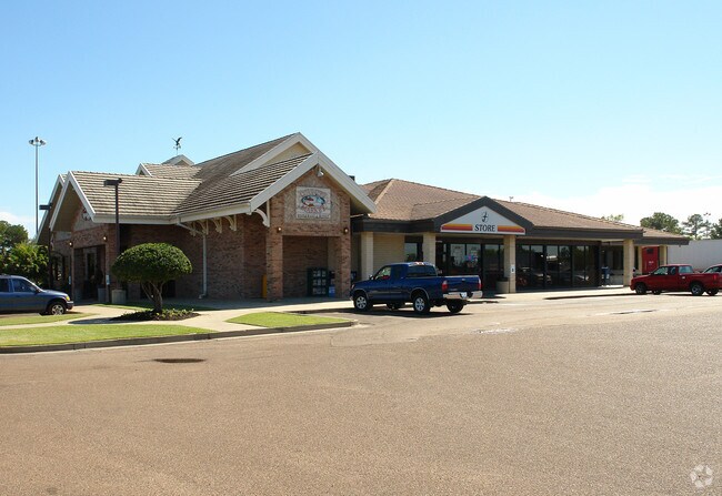
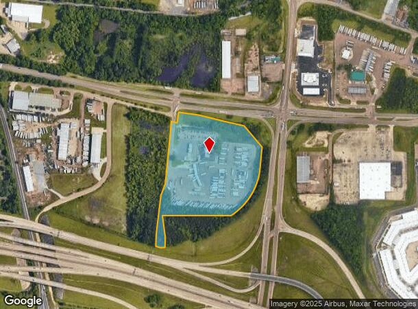
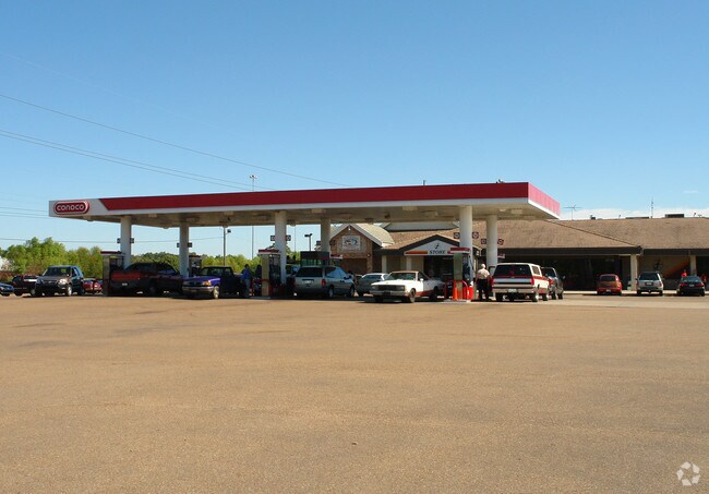
Property Record
685 Highway 80 E, Pearl, MS 39208
NEARBY LISTINGS FOR SALE OR LEASE
Property Detail
685 Highway 80 E
Jackson, MS
Flying J Sub
D08N-000039-00010
LOT 1 FLYING J SUB
Storebuilding
Rankin
AE
Mississippi
28121C0168G
1
2024
18.42 AC
2024
Brandon/Flowood/Pearl
020602
Jackson
16,948 SF
DEMOGRAPHICS near 685 Highway 80 E
1 Mile
3 Mile
5 Mile
2024 Total Population
587
20,556
85,480
2029 Population
617
20,626
84,918
Pop Growth 2024-2029
+ 5.11%
+ 0.34%
(0.66%)
Average Age
38
38
38
2024 Total Households
230
8,839
33,946
HH Growth 2024-2029
+ 5.22%
(0.02%)
(0.85%)
Median Household Inc
$31,000
$37,742
$35,241
Avg Household Size
2.50
2.10
2.30
2024 Avg HH Vehicles
2.00
2.00
2.00
Median Home Value
$73,295
$125,551
$98,694
Median Year Built
1983
1971
1968
Nearby Places
Map Layers
Map Styles
 Street
 Aerial
- Restaurants
- Banks
- Shops
- Fitness
- Groceries
PUBLIC TRANSPORTATION
COMMUTER RAIL
Jackson (City of New Orleans - Amtrak)
DRIVE
WALK
Distance
Jackson (City of New Orleans - Amtrak)
7 min
3.5 mi
AIRPORT
Jackson-Medgar Wiley Evers International
DRIVE
WALK
Distance
Jackson-Medgar Wiley Evers International
16 min
7.3 mi
Freight Ports
Port of Greater Baton Rouge
DRIVE
WALK
Distance
Port of Greater Baton Rouge
198 min
177.1 mi
Nearby Properties
Address
Land Use
TOTAL SIZE
Lot Size
Zoning
Address
Land Use
TOTAL SIZE
Lot Size
Zoning
435,199 SF
1.83 AC
Address
Land Use
TOTAL SIZE
Lot Size
Zoning
74,923 SF
0.01 AC
Address
Land Use
TOTAL SIZE
Lot Size
Zoning
9,650 SF
0.55 AC
Address
Land Use
TOTAL SIZE
Lot Size
Zoning
7.60 AC
Address
Land Use
TOTAL SIZE
Lot Size
Zoning
Address
Land Use
TOTAL SIZE
Lot Size
Zoning
206,400 SF
7.96 AC
Address
Land Use
TOTAL SIZE
Lot Size
Zoning
413,174 SF
2 AC
Address
Land Use
TOTAL SIZE
Lot Size
Zoning
40,148 SF
37.47 AC
Address
Land Use
TOTAL SIZE
Lot Size
Zoning
96,444 SF
0.88 AC
Address
Land Use
TOTAL SIZE
Lot Size
Zoning
247,574 SF
0.94 AC
Address
Land Use
TOTAL SIZE
Lot Size
Zoning
115,200 SF
0.35 AC
Address
Land Use
TOTAL SIZE
Lot Size
Zoning
58.94 AC
Address
Land Use
TOTAL SIZE
Lot Size
Zoning
17,261 SF
18.20 AC
Address
Land Use
TOTAL SIZE
Lot Size
Zoning
123,308 SF
20.88 AC
Address
Land Use
TOTAL SIZE
Lot Size
Zoning
46,958 SF
0.77 AC
Address
Land Use
TOTAL SIZE
Lot Size
Zoning
30,925 SF
38.73 AC
Address
Land Use
TOTAL SIZE
Lot Size
Zoning
31,541 SF
4 AC
Address
Land Use
TOTAL SIZE
Lot Size
Zoning
2,190,610 SF
2 AC
Address
Land Use
TOTAL SIZE
Lot Size
Zoning
47,885 SF
0.01 AC
Address
Land Use
TOTAL SIZE
Lot Size
Zoning
69,034 SF
0.64 AC
Address
Land Use
TOTAL SIZE
Lot Size
Zoning
9,081 SF
0.73 AC
Address
Land Use
TOTAL SIZE
Lot Size
Zoning
55,591 SF
1.01 AC
Address
Land Use
TOTAL SIZE
Lot Size
Zoning
0.01 AC
Address
Land Use
TOTAL SIZE
Lot Size
Zoning
42,520 SF
0.22 AC
Address
Land Use
TOTAL SIZE
Lot Size
Zoning
Address
Land Use
TOTAL SIZE
Lot Size
Zoning
28.60 AC
Address
Land Use
TOTAL SIZE
Lot Size
Zoning
38,189 SF
1.09 AC
Address
Land Use
TOTAL SIZE
Lot Size
Zoning
Address
Land Use
TOTAL SIZE
Lot Size
Zoning
2,348 SF
16.45 AC
Address
Land Use
TOTAL SIZE
Lot Size
Zoning
33,873 SF
0.96 AC
The World's #1 Commercial Real Estate Marketplace
Connect with us
© 2026 CoStar Group
The information above has been obtained from sources believed reliable. While we do not doubt its accuracy we have not verified it and make no guarantee, warranty or representation about it. It is your responsibility to independently confirm its accuracy and completeness. Any projections, opinions, assumptions, or estimates used are for example only and do not represent the current or future performance of the property. The value of this transaction to you depends on tax and other factors which should be evaluated by your tax, financial, and legal advisors. You and your advisors should conduct a careful, independent investigation of the property to determine to your satisfaction the suitability of the property for your needs.