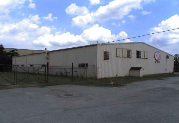
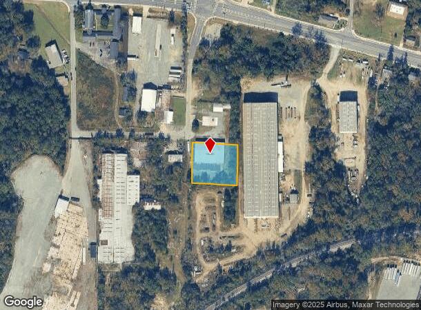
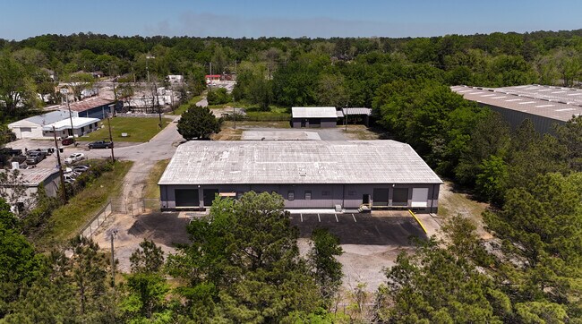
Property Record
685 S Millerfield Rd, Macon, GA 31217
NEARBY LISTINGS FOR SALE OR LEASE
Property Detail
685 S Millerfield Rd
T071-0047
Macon Reserve East
Warehouse
Bibb
X
Georgia
13169C0325E
50
2025
0.92 AC
2025
Macon
011702
Atlanta
13,440 SF
Macon-Bibb County, GA
DEMOGRAPHICS near 685 S Millerfield Rd
1 Mile
3 Mile
5 Mile
2024 Total Population
3,837
23,869
55,500
2029 Population
3,862
23,932
55,832
Pop Growth 2024-2029
+ 0.65%
+ 0.26%
+ 0.60%
Average Age
39
40
39
2024 Total Households
1,409
10,232
22,891
HH Growth 2024-2029
+ 0.85%
+ 0.23%
+ 0.71%
Median Household Inc
$27,254
$34,546
$35,802
Avg Household Size
2.50
2.20
2.20
2024 Avg HH Vehicles
1.00
2.00
1.00
Median Home Value
$68,881
$97,529
$109,197
Median Year Built
1959
1965
1965
Nearby Places
Map Layers
Map Styles
 Street
 Aerial
- Restaurants
- Banks
- Shops
- Fitness
- Groceries
SALE & LEASE HISTORY
LISTING DATE
SALE/LEASE

Oct 05, 2023
For Sale
Nov 19, 2019
For Sale
Jun 10, 2024
For Sale
Dec 20, 2021
For Lease
Dec 11, 2020
For Lease
Apr 22, 2024
For Lease
Nearby Properties
Address
Land Use
TOTAL SIZE
Lot Size
Zoning
Address
Land Use
TOTAL SIZE
Lot Size
Zoning
55,368 SF
9.53 AC
CBD-2
Address
Land Use
TOTAL SIZE
Lot Size
Zoning
213,690 SF
2.25 AC
CBD-1
Address
Land Use
TOTAL SIZE
Lot Size
Zoning
154,196 SF
44.86 AC
R-1A
Address
Land Use
TOTAL SIZE
Lot Size
Zoning
100,599 SF
0.43 AC
CBD-1
Address
Land Use
TOTAL SIZE
Lot Size
Zoning
158,480 SF
0.90 AC
CBD-2
Address
Land Use
TOTAL SIZE
Lot Size
Zoning
241,380 SF
12.38 AC
C-2
Address
Land Use
TOTAL SIZE
Lot Size
Zoning
155,678 SF
3.85 AC
CBD-2
Address
Land Use
TOTAL SIZE
Lot Size
Zoning
171,386 SF
36.41 AC
CBD-2
Address
Land Use
TOTAL SIZE
Lot Size
Zoning
145,967 SF
2.53 AC
C-4
Address
Land Use
TOTAL SIZE
Lot Size
Zoning
114,156 SF
0.86 AC
CBD-1
Address
Land Use
TOTAL SIZE
Lot Size
Zoning
246,724 SF
0.75 AC
CBD-1
Address
Land Use
TOTAL SIZE
Lot Size
Zoning
69,260 SF
0.41 AC
CBD-1
Address
Land Use
TOTAL SIZE
Lot Size
Zoning
60,432 SF
0.98 AC
CBD-1
Address
Land Use
TOTAL SIZE
Lot Size
Zoning
94,540 SF
6.15 AC
R-2
Address
Land Use
TOTAL SIZE
Lot Size
Zoning
183,682 SF
78.30 AC
M-2
Address
Land Use
TOTAL SIZE
Lot Size
Zoning
140 SF
29.43 AC
R-1
Address
Land Use
TOTAL SIZE
Lot Size
Zoning
72,073 SF
0.96 AC
CBD-1
Address
Land Use
TOTAL SIZE
Lot Size
Zoning
21,112 SF
1.11 AC
HR-3
Address
Land Use
TOTAL SIZE
Lot Size
Zoning
350,100 SF
51.92 AC
M-2
Address
Land Use
TOTAL SIZE
Lot Size
Zoning
145 SF
15.97 AC
R-3
Address
Land Use
TOTAL SIZE
Lot Size
Zoning
53,678 SF
0.58 AC
C-2
Address
Land Use
TOTAL SIZE
Lot Size
Zoning
80,546 SF
5.03 AC
CBD-1
Address
Land Use
TOTAL SIZE
Lot Size
Zoning
215,664 SF
1.12 AC
CBD-1
Address
Land Use
TOTAL SIZE
Lot Size
Zoning
103,740 SF
1.21 AC
CBD-1
Address
Land Use
TOTAL SIZE
Lot Size
Zoning
153,897 SF
26.73 AC
PDE
Address
Land Use
TOTAL SIZE
Lot Size
Zoning
2,025 SF
10.61 AC
R-3
Address
Land Use
TOTAL SIZE
Lot Size
Zoning
5,840 SF
120 AC
M-2
Address
Land Use
TOTAL SIZE
Lot Size
Zoning
45,986 SF
3.49 AC
C-2
Address
Land Use
TOTAL SIZE
Lot Size
Zoning
10,654 SF
10.09 AC
R-3
Address
Land Use
TOTAL SIZE
Lot Size
Zoning
18,308 SF
25.92 AC
R-3
The World's #1 Commercial Real Estate Marketplace
Connect with us
© 2025 CoStar Group
The information above has been obtained from sources believed reliable. While we do not doubt its accuracy we have not verified it and make no guarantee, warranty or representation about it. It is your responsibility to independently confirm its accuracy and completeness. Any projections, opinions, assumptions, or estimates used are for example only and do not represent the current or future performance of the property. The value of this transaction to you depends on tax and other factors which should be evaluated by your tax, financial, and legal advisors. You and your advisors should conduct a careful, independent investigation of the property to determine to your satisfaction the suitability of the property for your needs.