Property Record
685 South St, Wrentham, MA 02093
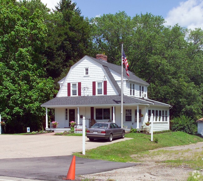
This Property Is For Sale
NEARBY LISTINGS FOR SALE OR LEASE
Property Detail
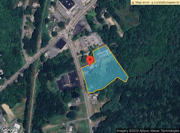
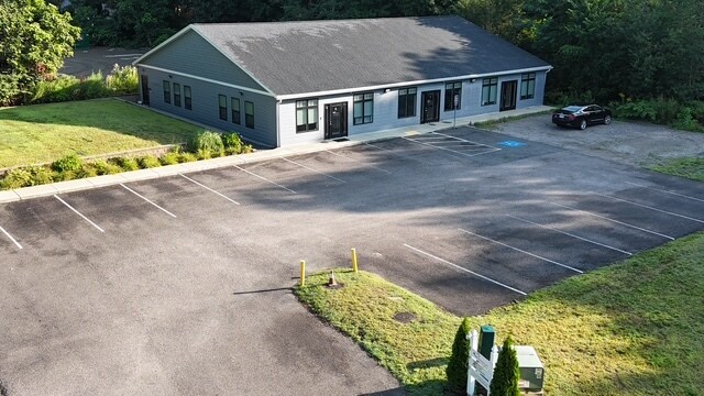
685 South St
WREN-000006K-000004-000006
Norfolk
Commercialofficeresidentialmixeduse
Massachusetts
A
6
25021C0336F
2.85 AC
0
I-95 Corridor South
2025
Boston
441203
Boston-Cambridge-Newton, MA-NH
1,784 SF
DEMOGRAPHICS near 685 South St
1 Mile
3 Mile
5 Mile
2024 Total Population
1,788
19,147
70,872
2029 Population
1,794
19,075
70,505
Pop Growth 2024-2029
+ 0.34%
(0.38%)
(0.52%)
Average Age
43
43
41
2024 Total Households
683
7,255
26,851
HH Growth 2024-2029
+ 0.44%
(0.40%)
(0.59%)
Median Household Inc
$159,108
$117,907
$116,067
Avg Household Size
2.60
2.60
2.60
2024 Avg HH Vehicles
2.00
2.00
2.00
Median Home Value
$625,000
$567,158
$497,283
Median Year Built
1973
1982
1978
Nearby Places
- Restaurants
- Banks
- Shops
- Fitness
- Groceries
PUBLIC TRANSPORTATION
COMMUTER RAIL
Franklin (Franklin Line - Massachusetts Bay Transportation Authority Commuter Rail (Purple Line))
DRIVE
WALK
Distance
Franklin (Franklin Line - Massachusetts Bay Transportation Authority Commuter Rail (Purple Line))
9 min
5.7 mi
Foxboro (Special Events Only) (Foxboro Line (Special Events Only) - Massachusetts Bay Transportation Authority Commuter Rail (Purple Line))
DRIVE
WALK
Distance
Foxboro (Special Events Only) (Foxboro Line (Special Events Only) - Massachusetts Bay Transportation Authority Commuter Rail (Purple Line))
12 min
6.4 mi
AIRPORT
Rhode Island Tf Green International
DRIVE
WALK
Distance
Rhode Island Tf Green International
48 min
31.7 mi
General Edward Lawrence Logan International
DRIVE
WALK
Distance
General Edward Lawrence Logan International
54 min
32.1 mi
Worcester Regional
DRIVE
WALK
Distance
Worcester Regional
58 min
40.4 mi
Nearby Properties
Address
Land Use
TOTAL SIZE
Lot Size
Zoning
Address
Land Use
TOTAL SIZE
Lot Size
Zoning
52,064 SF
87.51 AC
CI
Address
Land Use
TOTAL SIZE
Lot Size
Zoning
14,317 SF
411.17 AC
R-43
Address
Land Use
TOTAL SIZE
Lot Size
Zoning
39.30 AC
Address
Land Use
TOTAL SIZE
Lot Size
Zoning
31.57 AC
Address
Land Use
TOTAL SIZE
Lot Size
Zoning
663,031 SF
44.44 AC
IB
Address
Land Use
TOTAL SIZE
Lot Size
Zoning
0.58 AC
Address
Land Use
TOTAL SIZE
Lot Size
Zoning
96,596 SF
17.01 AC
C-2 80
Address
Land Use
TOTAL SIZE
Lot Size
Zoning
231,487 SF
33.15 AC
R-30
Address
Land Use
TOTAL SIZE
Lot Size
Zoning
4.14 AC
Address
Land Use
TOTAL SIZE
Lot Size
Zoning
19,742 SF
58.34 AC
R-43
Address
Land Use
TOTAL SIZE
Lot Size
Zoning
16.99 AC
Address
Land Use
TOTAL SIZE
Lot Size
Zoning
232,152 SF
17.07 AC
Address
Land Use
TOTAL SIZE
Lot Size
Zoning
39.40 AC
Address
Land Use
TOTAL SIZE
Lot Size
Zoning
28.55 AC
CC
Address
Land Use
TOTAL SIZE
Lot Size
Zoning
176,269 SF
40.56 AC
B-2 80
Address
Land Use
TOTAL SIZE
Lot Size
Zoning
142,040 SF
18.16 AC
CI
Address
Land Use
TOTAL SIZE
Lot Size
Zoning
130,500 SF
9.52 AC
Address
Land Use
TOTAL SIZE
Lot Size
Zoning
226,472 SF
12.07 AC
Address
Land Use
TOTAL SIZE
Lot Size
Zoning
Address
Land Use
TOTAL SIZE
Lot Size
Zoning
22 AC
CI
Address
Land Use
TOTAL SIZE
Lot Size
Zoning
3,024 SF
12.47 AC
C-1 80
Address
Land Use
TOTAL SIZE
Lot Size
Zoning
259,280 SF
20 AC
Address
Land Use
TOTAL SIZE
Lot Size
Zoning
12.32 AC
Address
Land Use
TOTAL SIZE
Lot Size
Zoning
101,882 SF
7.10 AC
Address
Land Use
TOTAL SIZE
Lot Size
Zoning
10,984 SF
8.52 AC
B-1 10
Address
Land Use
TOTAL SIZE
Lot Size
Zoning
132,952 SF
13.64 AC
Address
Land Use
TOTAL SIZE
Lot Size
Zoning
141,049 SF
22.77 AC
CI
Address
Land Use
TOTAL SIZE
Lot Size
Zoning
9,945 SF
16.72 AC
C-2 80
Address
Land Use
TOTAL SIZE
Lot Size
Zoning
51,110 SF
2.11 AC
Address
Land Use
TOTAL SIZE
Lot Size
Zoning
134,410 SF
18.26 AC
The World's #1 Commercial Real Estate Marketplace
Connect with us
© 2025 CoStar Group
The information above has been obtained from sources believed reliable. While we do not doubt its accuracy we have not verified it and make no guarantee, warranty or representation about it. It is your responsibility to independently confirm its accuracy and completeness. Any projections, opinions, assumptions, or estimates used are for example only and do not represent the current or future performance of the property. The value of this transaction to you depends on tax and other factors which should be evaluated by your tax, financial, and legal advisors. You and your advisors should conduct a careful, independent investigation of the property to determine to your satisfaction the suitability of the property for your needs.