Property Record
6850 S Brosius Ave, Tucson, AZ 85756


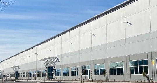
Property Detail
6850 S Brosius Ave
140-41-8480
ROCKEFELLER GROUP DISTRIBUTION CENTER LOT 1
Warehouse
Pima
I1
Arizona
B and X Area of moderate flood hazard, usually the area between the limits of the 100-year and 500-year floods.
1
2025
8.33 AC
2026
SW Tucson/Airport
980002
Tucson
157,500 SF
Tucson, AZ
NEARBY LISTINGS FOR SALE OR LEASE
DEMOGRAPHICS near 6850 S Brosius Ave
1 mile
3 mile
5 mile
2025 Total Population
2,537
54,747
119,816
2030 Population
2,621
56,251
123,067
Pop Growth 2025-2030
+ 3.31%
+ 2.75%
+ 2.71%
Average Age
32
35
35
2025 Total Households
761
17,943
39,285
HH Growth 2025-2030
+ 3.55%
+ 2.81%
+ 2.75%
Median Household Inc
$100,243
$54,932
$55,374
Avg Household Size
3.10
3.00
2.90
2025 Avg HH Vehicles
2.00
2.00
2.00
Median Home Value
$292,856
$214,277
$216,697
Median Year Built
2005
1986
1983
Nearby Places
Map Layers
Map Styles
 Street
 Aerial
Layers
 Traffic
 Biking
Places
Listings with unknown addresses are not visible on the map
- Restaurants
- Banks
- Shops
- Fitness
- Groceries
PUBLIC TRANSPORTATION
AIRPORT
Tucson International
Drive
Walk
Distance
Tucson International
4 min
1.7 mi
Freight Ports
Port of San Diego
Drive
Walk
Distance
Port of San Diego
1 min
365.9 mi
SALE & LEASE HISTORY
LISTING DATE
SALE/LEASE

Sep 25, 2016
For Lease
Dec 07, 2018
For Lease
Nearby Properties
Address
Land Use
TOTAL SIZE
Lot Size
Zoning
Address
Land Use
TOTAL SIZE
Lot Size
Zoning
152,116 SF
17.35 AC
I1
Address
Land Use
TOTAL SIZE
Lot Size
Zoning
858,288 SF
111.53 AC
Address
Land Use
TOTAL SIZE
Lot Size
Zoning
1,214,337 SF
78.85 AC
Address
Land Use
TOTAL SIZE
Lot Size
Zoning
536,702 SF
84.11 AC
CI1
Address
Land Use
TOTAL SIZE
Lot Size
Zoning
1,002,636 SF
751.86 AC
Address
Land Use
TOTAL SIZE
Lot Size
Zoning
35,257 SF
24.86 AC
Address
Land Use
TOTAL SIZE
Lot Size
Zoning
302,444 SF
17 AC
I1
Address
Land Use
TOTAL SIZE
Lot Size
Zoning
1,037,850 SF
618.47 AC
CI2
Address
Land Use
TOTAL SIZE
Lot Size
Zoning
298,989 SF
21.76 AC
Address
Land Use
TOTAL SIZE
Lot Size
Zoning
229,320 SF
25.85 AC
Address
Land Use
TOTAL SIZE
Lot Size
Zoning
12,078 SF
43.80 AC
TH
Address
Land Use
TOTAL SIZE
Lot Size
Zoning
413,807 SF
514.76 AC
CI2
Address
Land Use
TOTAL SIZE
Lot Size
Zoning
259,279 SF
15 AC
Address
Land Use
TOTAL SIZE
Lot Size
Zoning
296,721 SF
36.54 AC
R2
Address
Land Use
TOTAL SIZE
Lot Size
Zoning
244,889 SF
15.03 AC
I1
Address
Land Use
TOTAL SIZE
Lot Size
Zoning
278,071 SF
45.73 AC
CI1
Address
Land Use
TOTAL SIZE
Lot Size
Zoning
30,000 SF
4.34 AC
I1
Address
Land Use
TOTAL SIZE
Lot Size
Zoning
33.99 AC
CI1
Address
Land Use
TOTAL SIZE
Lot Size
Zoning
183,196 SF
36.82 AC
R2
Address
Land Use
TOTAL SIZE
Lot Size
Zoning
81.23 AC
Address
Land Use
TOTAL SIZE
Lot Size
Zoning
31.71 AC
Address
Land Use
TOTAL SIZE
Lot Size
Zoning
165.26 AC
Address
Land Use
TOTAL SIZE
Lot Size
Zoning
141,501 SF
10.33 AC
I1
Address
Land Use
TOTAL SIZE
Lot Size
Zoning
2,243,466 SF
222.91 AC
CI2
Address
Land Use
TOTAL SIZE
Lot Size
Zoning
114,285 SF
5.17 AC
R2
Address
Land Use
TOTAL SIZE
Lot Size
Zoning
157,271 SF
25.24 AC
CR3
Address
Land Use
TOTAL SIZE
Lot Size
Zoning
4,433 SF
2.90 AC
R2
Address
Land Use
TOTAL SIZE
Lot Size
Zoning
210,359 SF
5.58 AC
Address
Land Use
TOTAL SIZE
Lot Size
Zoning
207,870 SF
38.40 AC
The World's #1 Commercial Real Estate Marketplace
Connect with us
© 2026 CoStar Group
The information above has been obtained from sources believed reliable. While we do not doubt its accuracy we have not verified it and make no guarantee, warranty or representation about it. It is your responsibility to independently confirm its accuracy and completeness. Any projections, opinions, assumptions, or estimates used are for example only and do not represent the current or future performance of the property. The value of this transaction to you depends on tax and other factors which should be evaluated by your tax, financial, and legal advisors. You and your advisors should conduct a careful, independent investigation of the property to determine to your satisfaction the suitability of the property for your needs.