Property Record
6854 Adobe Rd, Twentynine Palms, CA 92277
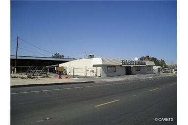
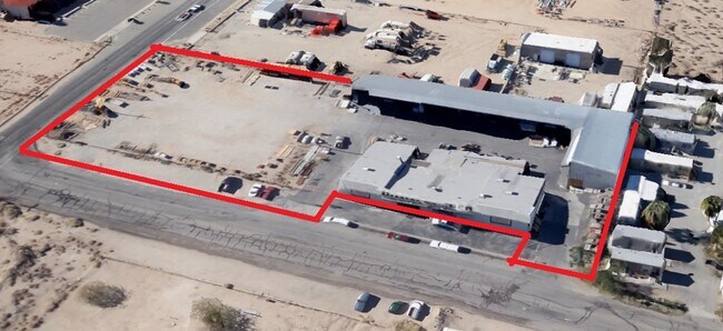

Property Detail
6854 Adobe Rd
Riverside-San Bernardino-Ontario, CA
N 208 FT S 416 FT E 208 FT NE 1/4 SEC 32 TP 1N R 9E EX E 40 FT ST
0617-142-14
SAN BERNARDINO
Storebuilding
California
2025
0.80 AC
2025
Twentynine Palms
010434
Inland Empire (California)
6,837 SF
NEARBY LISTINGS FOR SALE OR LEASE
-
-
View all Twentynine Palms listings for sale on LoopNet.com
DEMOGRAPHICS near 6854 Adobe Rd
1 mile
3 mile
5 mile
2025 Total Population
3,466
16,438
18,194
2030 Population
3,633
17,093
18,926
Pop Growth 2025-2030
+ 4.82%
+ 3.98%
+ 4.02%
Average Age
35
35
36
2025 Total Households
1,525
6,729
7,454
HH Growth 2025-2030
+ 4.85%
+ 3.98%
+ 4.01%
Median Household Inc
$46,319
$57,924
$58,796
Avg Household Size
2.20
2.40
2.40
2025 Avg HH Vehicles
2.00
2.00
2.00
Median Home Value
$335,593
$298,500
$293,717
Median Year Built
1987
1985
1985
Nearby Places
Map Layers
Map Styles
 Street
 Aerial
Layers
 Traffic
 Biking
Places
Listings with unknown addresses are not visible on the map
- Restaurants
- Banks
- Shops
- Fitness
- Groceries
SALE & LEASE HISTORY
LISTING DATE
SALE/LEASE

Sep 11, 2025
For Sale
Nearby Properties
Address
Land Use
TOTAL SIZE
Lot Size
Zoning
Address
Land Use
TOTAL SIZE
Lot Size
Zoning
448,671 SF
65.68 AC
Address
Land Use
TOTAL SIZE
Lot Size
Zoning
252,350 SF
29.43 AC
Address
Land Use
TOTAL SIZE
Lot Size
Zoning
49,866 SF
3.63 AC
Address
Land Use
TOTAL SIZE
Lot Size
Zoning
47,763 SF
1.43 AC
Address
Land Use
TOTAL SIZE
Lot Size
Zoning
79,214 SF
4.93 AC
Address
Land Use
TOTAL SIZE
Lot Size
Zoning
17,394 SF
1.87 AC
Address
Land Use
TOTAL SIZE
Lot Size
Zoning
35,970 SF
7.21 AC
Address
Land Use
TOTAL SIZE
Lot Size
Zoning
16,000 SF
2.78 AC
Address
Land Use
TOTAL SIZE
Lot Size
Zoning
24,425 SF
1.22 AC
Address
Land Use
TOTAL SIZE
Lot Size
Zoning
36,478 SF
2.30 AC
Address
Land Use
TOTAL SIZE
Lot Size
Zoning
45,360 SF
4.23 AC
Address
Land Use
TOTAL SIZE
Lot Size
Zoning
18,072 SF
1.38 AC
Address
Land Use
TOTAL SIZE
Lot Size
Zoning
2,000 SF
0.23 AC
Address
Land Use
TOTAL SIZE
Lot Size
Zoning
12,153 SF
1.40 AC
Address
Land Use
TOTAL SIZE
Lot Size
Zoning
10,559 SF
1.11 AC
Address
Land Use
TOTAL SIZE
Lot Size
Zoning
45,226 SF
6.71 AC
Address
Land Use
TOTAL SIZE
Lot Size
Zoning
12,914 SF
17.06 AC
Address
Land Use
TOTAL SIZE
Lot Size
Zoning
9,370 SF
0.81 AC
Address
Land Use
TOTAL SIZE
Lot Size
Zoning
35,826 SF
2.70 AC
Address
Land Use
TOTAL SIZE
Lot Size
Zoning
960 SF
3.22 AC
Address
Land Use
TOTAL SIZE
Lot Size
Zoning
2,121 SF
0.32 AC
Address
Land Use
TOTAL SIZE
Lot Size
Zoning
7,225 SF
1.18 AC
Address
Land Use
TOTAL SIZE
Lot Size
Zoning
9,187 SF
31.13 AC
Address
Land Use
TOTAL SIZE
Lot Size
Zoning
37,380 SF
3.03 AC
Address
Land Use
TOTAL SIZE
Lot Size
Zoning
60,440 SF
2.38 AC
Address
Land Use
TOTAL SIZE
Lot Size
Zoning
18,200 SF
7.80 AC
Address
Land Use
TOTAL SIZE
Lot Size
Zoning
2,239 SF
1.12 AC
Address
Land Use
TOTAL SIZE
Lot Size
Zoning
18,790 SF
7.71 AC
Address
Land Use
TOTAL SIZE
Lot Size
Zoning
38,453 SF
6 AC
Address
Land Use
TOTAL SIZE
Lot Size
Zoning
15,506 SF
1.53 AC
The World's #1 Commercial Real Estate Marketplace
Connect with us
© 2026 CoStar Group
The information above has been obtained from sources believed reliable. While we do not doubt its accuracy we have not verified it and make no guarantee, warranty or representation about it. It is your responsibility to independently confirm its accuracy and completeness. Any projections, opinions, assumptions, or estimates used are for example only and do not represent the current or future performance of the property. The value of this transaction to you depends on tax and other factors which should be evaluated by your tax, financial, and legal advisors. You and your advisors should conduct a careful, independent investigation of the property to determine to your satisfaction the suitability of the property for your needs.