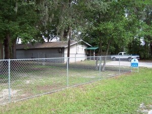
Property Record
6861 Lenox Ave, Jacksonville, FL 32205


NEARBY LISTINGS FOR SALE OR LEASE
Property Detail
6861 Lenox Ave
Jacksonville, FL
Lackawanna
011683-0010
4-66 39-2S-25E .258 LACKAWANNA N 75FT OF W 150FT LOT 8 BLK 56
Storebuilding
Duval
X
Florida
12031C0342J
8
2025
0.26 AC
2026
Riverside
012601
Jacksonville (Florida)
2,028 SF
DEMOGRAPHICS near 6861 Lenox Ave
1 Mile
3 Mile
5 Mile
2024 Total Population
9,595
73,254
170,684
2029 Population
10,186
76,704
179,149
Pop Growth 2024-2029
+ 6.16%
+ 4.71%
+ 4.96%
Average Age
36
38
38
2024 Total Households
3,884
29,273
68,236
HH Growth 2024-2029
+ 6.39%
+ 4.84%
+ 5.11%
Median Household Inc
$42,361
$51,249
$52,413
Avg Household Size
2.30
2.40
2.40
2024 Avg HH Vehicles
1.00
2.00
2.00
Median Home Value
$167,140
$171,543
$188,056
Median Year Built
1972
1968
1971
Nearby Places
Map Layers
Map Styles
 Street
 Aerial
- Restaurants
- Banks
- Shops
- Fitness
- Groceries
PUBLIC TRANSPORTATION
COMMUTER RAIL
Jacksonville (Silver Meteor - Amtrak, Silver Star - Amtrak)
DRIVE
WALK
Distance
Jacksonville (Silver Meteor - Amtrak, Silver Star - Amtrak)
14 min
6.7 mi
AIRPORT
Jacksonville International
DRIVE
WALK
Distance
Jacksonville International
28 min
18.8 mi
Freight Ports
Jacksonville Port
DRIVE
WALK
Distance
Jacksonville Port
19 min
10.9 mi
Nearby Properties
Address
Land Use
TOTAL SIZE
Lot Size
Zoning
Address
Land Use
TOTAL SIZE
Lot Size
Zoning
744,280 SF
53.40 AC
RMD-D
Address
Land Use
TOTAL SIZE
Lot Size
Zoning
185,662 SF
1,416.80 AC
PBF-3
Address
Land Use
TOTAL SIZE
Lot Size
Zoning
465,664 SF
21.27 AC
IL
Address
Land Use
TOTAL SIZE
Lot Size
Zoning
888,083 SF
46.65 AC
IL
Address
Land Use
TOTAL SIZE
Lot Size
Zoning
321,547 SF
17.17 AC
PUD
Address
Land Use
TOTAL SIZE
Lot Size
Zoning
222,138 SF
13.18 AC
IL
Address
Land Use
TOTAL SIZE
Lot Size
Zoning
184,092 SF
21.69 AC
CCG-1
Address
Land Use
TOTAL SIZE
Lot Size
Zoning
505,748 SF
94.71 AC
IL
Address
Land Use
TOTAL SIZE
Lot Size
Zoning
290,599 SF
27.84 AC
RMD-D
Address
Land Use
TOTAL SIZE
Lot Size
Zoning
291,338 SF
37 AC
PBF-1
Address
Land Use
TOTAL SIZE
Lot Size
Zoning
179,916 SF
12.19 AC
RMD-D
Address
Land Use
TOTAL SIZE
Lot Size
Zoning
147,066 SF
3.30 AC
PUD
Address
Land Use
TOTAL SIZE
Lot Size
Zoning
310,972 SF
19.91 AC
RMD-D
Address
Land Use
TOTAL SIZE
Lot Size
Zoning
233,363 SF
20.36 AC
PUD
Address
Land Use
TOTAL SIZE
Lot Size
Zoning
139,435 SF
7.15 AC
CCG-2
Address
Land Use
TOTAL SIZE
Lot Size
Zoning
309,137 SF
20.09 AC
RMD-D
Address
Land Use
TOTAL SIZE
Lot Size
Zoning
129,506 SF
21.68 AC
CCG-2
Address
Land Use
TOTAL SIZE
Lot Size
Zoning
64,013 SF
8.37 AC
PUD
Address
Land Use
TOTAL SIZE
Lot Size
Zoning
196,790 SF
12.62 AC
RMD-D
Address
Land Use
TOTAL SIZE
Lot Size
Zoning
240,410 SF
16.76 AC
IL
Address
Land Use
TOTAL SIZE
Lot Size
Zoning
206,513 SF
9.83 AC
RMD-D
Address
Land Use
TOTAL SIZE
Lot Size
Zoning
169,370 SF
10.87 AC
RMD-D
Address
Land Use
TOTAL SIZE
Lot Size
Zoning
231,044 SF
10.94 AC
RMD-D
Address
Land Use
TOTAL SIZE
Lot Size
Zoning
70,460 SF
1.66 AC
CCG-2
Address
Land Use
TOTAL SIZE
Lot Size
Zoning
209,480 SF
22.42 AC
CCG-1
Address
Land Use
TOTAL SIZE
Lot Size
Zoning
114,316 SF
20.57 AC
IL
Address
Land Use
TOTAL SIZE
Lot Size
Zoning
279,053 SF
21.03 AC
IBP
Address
Land Use
TOTAL SIZE
Lot Size
Zoning
46,139 SF
2.77 AC
PUD
Address
Land Use
TOTAL SIZE
Lot Size
Zoning
170,550 SF
7.48 AC
IL
Address
Land Use
TOTAL SIZE
Lot Size
Zoning
167,854 SF
8.01 AC
IL
The World's #1 Commercial Real Estate Marketplace
Connect with us
© 2026 CoStar Group
The information above has been obtained from sources believed reliable. While we do not doubt its accuracy we have not verified it and make no guarantee, warranty or representation about it. It is your responsibility to independently confirm its accuracy and completeness. Any projections, opinions, assumptions, or estimates used are for example only and do not represent the current or future performance of the property. The value of this transaction to you depends on tax and other factors which should be evaluated by your tax, financial, and legal advisors. You and your advisors should conduct a careful, independent investigation of the property to determine to your satisfaction the suitability of the property for your needs.