Property Record
6861 N 41 Hwy, Apollo Beach, FL 33572
NEARBY LISTINGS FOR SALE OR LEASE
-
-
View all Apollo Beach listings for sale on LoopNet.com
Property Detail
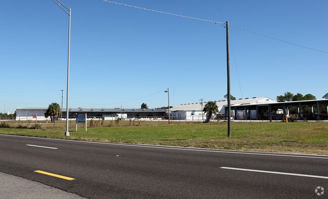
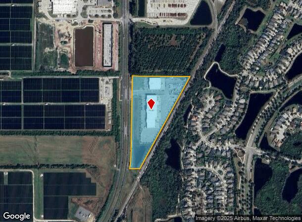
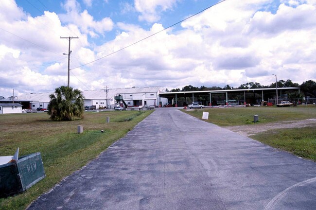
6861 N 41 Hwy
Tampa-St. Petersburg-Clearwater, FL
Unplatted
U-14-31-19-ZZZ-000001-74350.0
THAT PART OF NW 1/4 OF SW 1/4 DESC AS : BEG AT INTER OF WLY R/W LINE OF ACL RR AND E BDRY LINE OF SR 23 AND RUN N 28 DEG 36 MIN 28 SEC E ALONG RR 1700.75 FT N 89 DEG 32 MIN 36 SEC W 704.83 FT N 84 DEG 10 MIN 15 SEC W 90.35 FT TO ELY R/W OF SR 23 AND
Warehouse
Hillsborough
X
Florida
12057C0492J
74350
2024
13.92 AC
2024
SE Hillsborough
014106
Tampa/St Petersburg
91,823 SF
DEMOGRAPHICS near 6861 N 41 Hwy
1 Mile
3 Mile
5 Mile
2024 Total Population
5,612
45,311
137,881
2029 Population
6,207
51,052
153,659
Pop Growth 2024-2029
+ 10.60%
+ 12.67%
+ 11.44%
Average Age
39
39
39
2024 Total Households
2,053
16,263
48,528
HH Growth 2024-2029
+ 10.96%
+ 12.73%
+ 11.70%
Median Household Inc
$102,246
$93,866
$88,897
Avg Household Size
2.70
2.80
2.80
2024 Avg HH Vehicles
2.00
2.00
2.00
Median Home Value
$337,878
$333,542
$293,631
Median Year Built
2007
2009
2009
Nearby Places
Map Layers
Map Styles
 Street
 Aerial
- Restaurants
- Banks
- Shops
- Fitness
- Groceries
PUBLIC TRANSPORTATION
AIRPORT
Tampa International
DRIVE
WALK
Distance
Tampa International
37 min
24.2 mi
St Pete-Clearwater International
DRIVE
WALK
Distance
St Pete-Clearwater International
48 min
32.7 mi
Sarasota/Bradenton International
DRIVE
WALK
Distance
Sarasota/Bradenton International
53 min
33.6 mi
Freight Ports
Port of Tampa Bay
DRIVE
WALK
Distance
Port of Tampa Bay
23 min
13.5 mi
Nearby Properties
Address
Land Use
TOTAL SIZE
Lot Size
Zoning
Address
Land Use
TOTAL SIZE
Lot Size
Zoning
647,720 SF
68.52 AC
PD
Address
Land Use
TOTAL SIZE
Lot Size
Zoning
503,703 SF
21 AC
PD
Address
Land Use
TOTAL SIZE
Lot Size
Zoning
493,204 SF
65.35 AC
M
Address
Land Use
TOTAL SIZE
Lot Size
Zoning
419,897 SF
18.09 AC
PD
Address
Land Use
TOTAL SIZE
Lot Size
Zoning
317,172 SF
36.54 AC
PD
Address
Land Use
TOTAL SIZE
Lot Size
Zoning
593,167 SF
416.07 AC
M
Address
Land Use
TOTAL SIZE
Lot Size
Zoning
382,614 SF
23.72 AC
IPD-1
Address
Land Use
TOTAL SIZE
Lot Size
Zoning
334,871 SF
15 AC
PD
Address
Land Use
TOTAL SIZE
Lot Size
Zoning
154,232 SF
17.40 AC
PD
Address
Land Use
TOTAL SIZE
Lot Size
Zoning
347,147 SF
258.94 AC
PD
Address
Land Use
TOTAL SIZE
Lot Size
Zoning
425,231 SF
23.78 AC
M
Address
Land Use
TOTAL SIZE
Lot Size
Zoning
101,768 SF
17.94 AC
PD
Address
Land Use
TOTAL SIZE
Lot Size
Zoning
146,440 SF
18.56 AC
PD
Address
Land Use
TOTAL SIZE
Lot Size
Zoning
48,968 SF
10 AC
PD
Address
Land Use
TOTAL SIZE
Lot Size
Zoning
520,366 SF
122.24 AC
PD
Address
Land Use
TOTAL SIZE
Lot Size
Zoning
441,257 SF
107.09 AC
AR
Address
Land Use
TOTAL SIZE
Lot Size
Zoning
178,496 SF
17.63 AC
PD
Address
Land Use
TOTAL SIZE
Lot Size
Zoning
64,512 SF
22.33 AC
PD
Address
Land Use
TOTAL SIZE
Lot Size
Zoning
93,256 SF
14.82 AC
PD
Address
Land Use
TOTAL SIZE
Lot Size
Zoning
108,036 SF
11.70 AC
PD
Address
Land Use
TOTAL SIZE
Lot Size
Zoning
94,955 SF
13.55 AC
PD
Address
Land Use
TOTAL SIZE
Lot Size
Zoning
230,880 SF
25.13 AC
AI
Address
Land Use
TOTAL SIZE
Lot Size
Zoning
191,459 SF
13.60 AC
M
Address
Land Use
TOTAL SIZE
Lot Size
Zoning
88,445 SF
14.41 AC
PD
Address
Land Use
TOTAL SIZE
Lot Size
Zoning
81,193 SF
11.41 AC
PD
Address
Land Use
TOTAL SIZE
Lot Size
Zoning
138,316 SF
13.27 AC
PD
Address
Land Use
TOTAL SIZE
Lot Size
Zoning
110,148 SF
23.04 AC
M
Address
Land Use
TOTAL SIZE
Lot Size
Zoning
924 SF
563.45 AC
AR
Address
Land Use
TOTAL SIZE
Lot Size
Zoning
40,676 SF
8.56 AC
M
Address
Land Use
TOTAL SIZE
Lot Size
Zoning
76,280 SF
3.87 AC
PD
The World's #1 Commercial Real Estate Marketplace
Connect with us
© 2026 CoStar Group
The information above has been obtained from sources believed reliable. While we do not doubt its accuracy we have not verified it and make no guarantee, warranty or representation about it. It is your responsibility to independently confirm its accuracy and completeness. Any projections, opinions, assumptions, or estimates used are for example only and do not represent the current or future performance of the property. The value of this transaction to you depends on tax and other factors which should be evaluated by your tax, financial, and legal advisors. You and your advisors should conduct a careful, independent investigation of the property to determine to your satisfaction the suitability of the property for your needs.