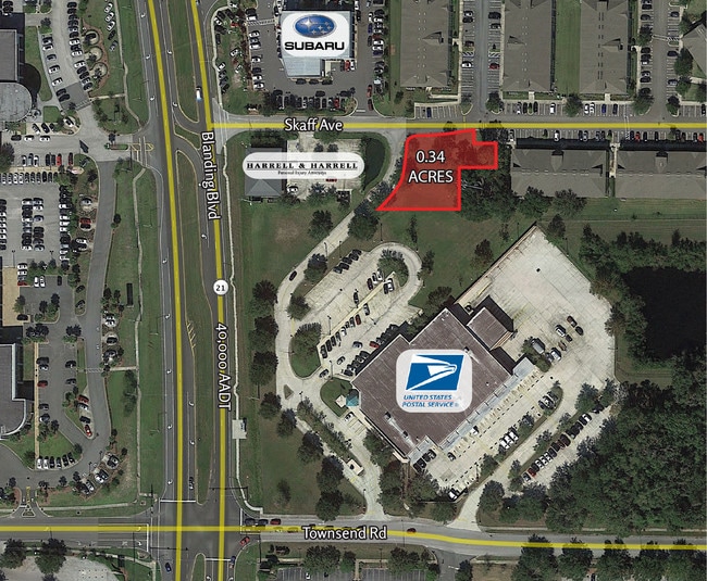
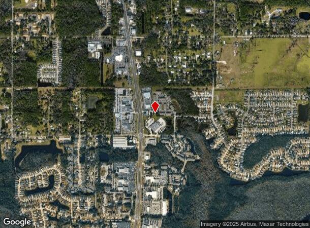
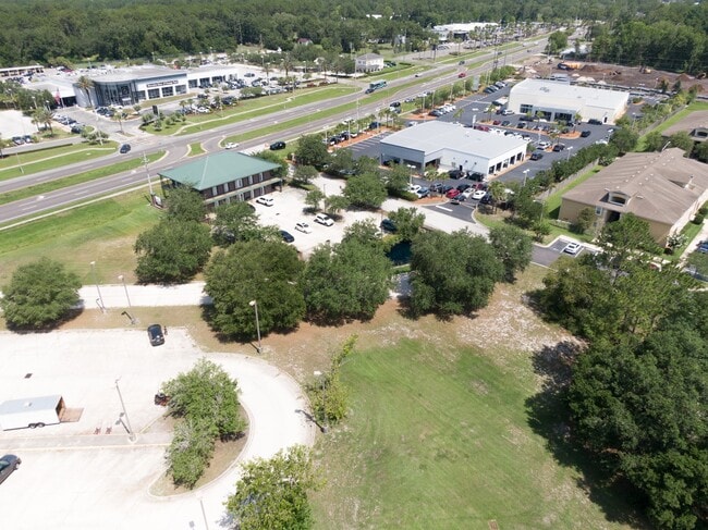
Property Record
1 Blanding Blvd, Jacksonville, FL 32244
Current Lease Availabilities
NEARBY LISTINGS FOR SALE OR LEASE
Property Detail
1 Blanding Blvd
Jacksonville, FL
Section Land
098279-1895
19-3S-26E .34 PT SE1/4 OF SE1/4 RECD O/R 20828-349
Commercialacreage
Duval
X
Florida
12031C0526J
0.34 AC
2024
Riverside
2025
Jacksonville (Florida)
013526
DEMOGRAPHICS near 1 Blanding Blvd
1 Mile
3 Mile
5 Mile
2024 Total Population
8,552
70,638
170,878
2029 Population
8,985
74,568
180,798
Pop Growth 2024-2029
+ 5.06%
+ 5.56%
+ 5.81%
Average Age
36
38
39
2024 Total Households
3,262
27,989
65,415
HH Growth 2024-2029
+ 5.12%
+ 5.73%
+ 5.93%
Median Household Inc
$54,104
$52,297
$58,566
Avg Household Size
2.50
2.40
2.50
2024 Avg HH Vehicles
2.00
2.00
2.00
Median Home Value
$173,131
$176,249
$195,990
Median Year Built
2001
1987
1983
Nearby Places
Map Layers
Map Styles
 Street
 Aerial
- Restaurants
- Banks
- Shops
- Fitness
- Groceries
PUBLIC TRANSPORTATION
AIRPORT
Jacksonville International
DRIVE
WALK
Distance
Jacksonville International
37 min
24.8 mi
Freight Ports
Jacksonville Port
DRIVE
WALK
Distance
Jacksonville Port
26 min
14.8 mi
Nearby Properties
Address
Land Use
TOTAL SIZE
Lot Size
Zoning
Address
Land Use
TOTAL SIZE
Lot Size
Zoning
721,413 SF
46.72 AC
REBS
Address
Land Use
TOTAL SIZE
Lot Size
Zoning
336,253 SF
30.19 AC
PUD
Address
Land Use
TOTAL SIZE
Lot Size
Zoning
270,088 SF
18.50 AC
PUD
Address
Land Use
TOTAL SIZE
Lot Size
Zoning
411,303 SF
26.71 AC
RMD-C
Address
Land Use
TOTAL SIZE
Lot Size
Zoning
250,798 SF
16.84 AC
PUD
Address
Land Use
TOTAL SIZE
Lot Size
Zoning
246,982 SF
24.84 AC
PUD
Address
Land Use
TOTAL SIZE
Lot Size
Zoning
227,234 SF
19.99 AC
RD-4
Address
Land Use
TOTAL SIZE
Lot Size
Zoning
281,440 SF
17.01 AC
Address
Land Use
TOTAL SIZE
Lot Size
Zoning
402,240 SF
20.66 AC
PUD
Address
Land Use
TOTAL SIZE
Lot Size
Zoning
355,124 SF
18.80 AC
PUD
Address
Land Use
TOTAL SIZE
Lot Size
Zoning
278,173 SF
27.85 AC
Address
Land Use
TOTAL SIZE
Lot Size
Zoning
296,311 SF
20.07 AC
Address
Land Use
TOTAL SIZE
Lot Size
Zoning
290,919 SF
18.75 AC
PUD
Address
Land Use
TOTAL SIZE
Lot Size
Zoning
348,247 SF
31.85 AC
PUD
Address
Land Use
TOTAL SIZE
Lot Size
Zoning
244,004 SF
24.97 AC
PUD
Address
Land Use
TOTAL SIZE
Lot Size
Zoning
281,174 SF
25.34 AC
PUD
Address
Land Use
TOTAL SIZE
Lot Size
Zoning
188,666 SF
17.76 AC
PUD
Address
Land Use
TOTAL SIZE
Lot Size
Zoning
33,237 SF
33.08 AC
Address
Land Use
TOTAL SIZE
Lot Size
Zoning
203,724 SF
14.71 AC
RMD-D
Address
Land Use
TOTAL SIZE
Lot Size
Zoning
224,893 SF
13.51 AC
RMD-D
Address
Land Use
TOTAL SIZE
Lot Size
Zoning
272,076 SF
54.84 AC
PUD
Address
Land Use
TOTAL SIZE
Lot Size
Zoning
188,578 SF
13.44 AC
RMD-D
Address
Land Use
TOTAL SIZE
Lot Size
Zoning
216,883 SF
18.80 AC
CCG-1
Address
Land Use
TOTAL SIZE
Lot Size
Zoning
228,290 SF
12.65 AC
RMD-D
Address
Land Use
TOTAL SIZE
Lot Size
Zoning
168,475 SF
9.38 AC
RD-4
Address
Land Use
TOTAL SIZE
Lot Size
Zoning
277,225 SF
11.72 AC
RMD-D
Address
Land Use
TOTAL SIZE
Lot Size
Zoning
222,038 SF
18.22 AC
RMD-C
Address
Land Use
TOTAL SIZE
Lot Size
Zoning
207,697 SF
16.06 AC
PUD
Address
Land Use
TOTAL SIZE
Lot Size
Zoning
96,314 SF
21.05 AC
CCG-1
Address
Land Use
TOTAL SIZE
Lot Size
Zoning
159,684 SF
6.48 AC
The World's #1 Commercial Real Estate Marketplace
Connect with us
© 2026 CoStar Group
The information above has been obtained from sources believed reliable. While we do not doubt its accuracy we have not verified it and make no guarantee, warranty or representation about it. It is your responsibility to independently confirm its accuracy and completeness. Any projections, opinions, assumptions, or estimates used are for example only and do not represent the current or future performance of the property. The value of this transaction to you depends on tax and other factors which should be evaluated by your tax, financial, and legal advisors. You and your advisors should conduct a careful, independent investigation of the property to determine to your satisfaction the suitability of the property for your needs.