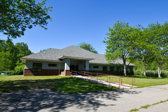
Property Record
6869 Marshall Rd, Dexter, MI 48130


NEARBY LISTINGS FOR SALE OR LEASE
Property Detail
6869 Marshall Rd
08-17-400-012
BEG AT CTR OF SEC 17, TH S 89-39-35 E 682.07 FT, TH S 00-20-25 W 964.45 FT, TH N 89-39-35 W 682.07 FT, TH N 00-20-25 E 964.45
Commercialnec
Washtenaw
X
Michigan
26161C0240E
15.01 AC
2025
Washtenaw W of 23
2025
Detroit
454001
Ann Arbor, MI
5,940 SF
DEMOGRAPHICS near 6869 Marshall Rd
1 mile
3 mile
5 mile
2024 Total Population
1,543
14,996
36,277
2029 Population
1,525
14,847
35,892
Pop Growth 2024-2029
(1.17%)
(0.99%)
(1.06%)
Average Age
39
41
42
2024 Total Households
652
5,883
14,236
HH Growth 2024-2029
(1.23%)
(1.04%)
(1.17%)
Median Household Inc
$55,545
$101,370
$115,842
Avg Household Size
2.40
2.50
2.50
2024 Avg HH Vehicles
2.00
2.00
2.00
Median Home Value
$71,030
$380,778
$422,216
Median Year Built
1987
1992
1989
Nearby Places
Map Layers
Map Styles
 Street
 Aerial
Transit
 Traffic
 Biking
Places
Listings with unknown addresses are not visible on the map
- Restaurants
- Banks
- Shops
- Fitness
- Groceries
PUBLIC TRANSPORTATION
COMMUTER RAIL
Drive
Walk
Distance
17 min
9.2 mi
AIRPORT
Detroit Metro Wayne County
Drive
Walk
Distance
Detroit Metro Wayne County
46 min
35.7 mi
SALE & LEASE HISTORY
LISTING DATE
SALE/LEASE

Jun 08, 2021
For Sale
Nearby Properties
Address
Land Use
TOTAL SIZE
Lot Size
Zoning
Address
Land Use
TOTAL SIZE
Lot Size
Zoning
1,760 SF
178.76 AC
MHP
Address
Land Use
TOTAL SIZE
Lot Size
Zoning
591,625 SF
80.39 AC
PUD
Address
Land Use
TOTAL SIZE
Lot Size
Zoning
177,474 SF
58.03 AC
C-2
Address
Land Use
TOTAL SIZE
Lot Size
Zoning
59.07 AC
R-C
Address
Land Use
TOTAL SIZE
Lot Size
Zoning
95,831 SF
26.98 AC
I-1
Address
Land Use
TOTAL SIZE
Lot Size
Zoning
132,280 SF
10.29 AC
I-1
Address
Land Use
TOTAL SIZE
Lot Size
Zoning
180,899 SF
32.64 AC
C-2
Address
Land Use
TOTAL SIZE
Lot Size
Zoning
460,082 SF
42.24 AC
RD
Address
Land Use
TOTAL SIZE
Lot Size
Zoning
147,400 SF
34.07 AC
SEVERAL
Address
Land Use
TOTAL SIZE
Lot Size
Zoning
180,899 SF
28.14 AC
C-2
Address
Land Use
TOTAL SIZE
Lot Size
Zoning
11.21 AC
MR-3
Address
Land Use
TOTAL SIZE
Lot Size
Zoning
148,595 SF
13.28 AC
I-1
Address
Land Use
TOTAL SIZE
Lot Size
Zoning
76,454 SF
8.94 AC
PUD
Address
Land Use
TOTAL SIZE
Lot Size
Zoning
177,614 SF
24.21 AC
SEVERAL
Address
Land Use
TOTAL SIZE
Lot Size
Zoning
443,838 SF
47.01 AC
I-1
Address
Land Use
TOTAL SIZE
Lot Size
Zoning
24.06 AC
R-3
Address
Land Use
TOTAL SIZE
Lot Size
Zoning
2,913 SF
25.61 AC
C-3
Address
Land Use
TOTAL SIZE
Lot Size
Zoning
181,364 SF
21.67 AC
I-2
Address
Land Use
TOTAL SIZE
Lot Size
Zoning
61,760 SF
18.06 AC
II
Address
Land Use
TOTAL SIZE
Lot Size
Zoning
55,085 SF
15.62 AC
I-1
Address
Land Use
TOTAL SIZE
Lot Size
Zoning
2,525 SF
28.42 AC
IRP
Address
Land Use
TOTAL SIZE
Lot Size
Zoning
102,200 SF
10.02 AC
C-2
Address
Land Use
TOTAL SIZE
Lot Size
Zoning
52,990 SF
20.49 AC
I-1
Address
Land Use
TOTAL SIZE
Lot Size
Zoning
Address
Land Use
TOTAL SIZE
Lot Size
Zoning
13.36 AC
R-3
Address
Land Use
TOTAL SIZE
Lot Size
Zoning
8.83 AC
PUD
Address
Land Use
TOTAL SIZE
Lot Size
Zoning
Address
Land Use
TOTAL SIZE
Lot Size
Zoning
4,154 SF
2.99 AC
C-2
Address
Land Use
TOTAL SIZE
Lot Size
Zoning
70,320 SF
2.79 AC
C-3
Address
Land Use
TOTAL SIZE
Lot Size
Zoning
12,795 SF
6.73 AC
C-2
The World's #1 Commercial Real Estate Marketplace
Connect with us
© 2026 CoStar Group
The information above has been obtained from sources believed reliable. While we do not doubt its accuracy we have not verified it and make no guarantee, warranty or representation about it. It is your responsibility to independently confirm its accuracy and completeness. Any projections, opinions, assumptions, or estimates used are for example only and do not represent the current or future performance of the property. The value of this transaction to you depends on tax and other factors which should be evaluated by your tax, financial, and legal advisors. You and your advisors should conduct a careful, independent investigation of the property to determine to your satisfaction the suitability of the property for your needs.