Property Record
6870 Okeechobee Blvd, West Palm Beach, FL 33411


NEARBY LISTINGS FOR SALE OR LEASE
Property Detail
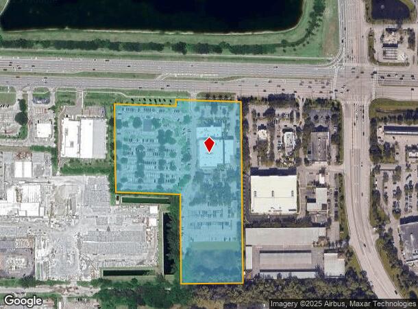
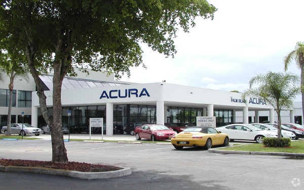
6870 Okeechobee Blvd
West Palm Beach-Boca Raton-Delray Beach, FL
Palm Beach Acura
74-42-43-28-44-001-0010
PALM BEACH ACURA PAR A (LESS NLY 343.07 FT OF WLY 12.31 FT & PAR IN OR24919P1080)
Vehiclerentalsvehiclesales
Palm Beach
AE
Florida
12099C0559F
a
2024
10.14 AC
2025
Royal Palm Bch/Wellington
007832
South Florida
35,434 SF
DEMOGRAPHICS near 6870 Okeechobee Blvd
1 Mile
3 Mile
5 Mile
2024 Total Population
9,030
72,146
219,099
2029 Population
9,238
74,955
225,593
Pop Growth 2024-2029
+ 2.30%
+ 3.89%
+ 2.96%
Average Age
44
44
40
2024 Total Households
3,952
30,067
82,800
HH Growth 2024-2029
+ 1.52%
+ 3.74%
+ 2.64%
Median Household Inc
$52,878
$50,237
$56,700
Avg Household Size
2.10
2.30
2.50
2024 Avg HH Vehicles
1.00
1.00
2.00
Median Home Value
$316,778
$221,784
$254,576
Median Year Built
1989
1984
1986
Nearby Places
Map Layers
Map Styles
 Street
 Aerial
- Restaurants
- Banks
- Shops
- Fitness
- Groceries
PUBLIC TRANSPORTATION
COMMUTER RAIL
West Palm Beach (Tri-County Commuter - South Florida Regional Transportation Authority (Tri-Rail))
DRIVE
WALK
Distance
West Palm Beach (Tri-County Commuter - South Florida Regional Transportation Authority (Tri-Rail))
12 min
6.2 mi
DRIVE
WALK
Distance
14 min
6.7 mi
AIRPORT
Palm Beach International
DRIVE
WALK
Distance
Palm Beach International
12 min
5.7 mi
Freight Ports
Port of Palm Beach
DRIVE
WALK
Distance
Port of Palm Beach
20 min
10.2 mi
Nearby Properties
Address
Land Use
TOTAL SIZE
Lot Size
Zoning
Address
Land Use
TOTAL SIZE
Lot Size
Zoning
644,690 SF
44.88 AC
MUPD
Address
Land Use
TOTAL SIZE
Lot Size
Zoning
490,757 SF
12.11 AC
PIPD
Address
Land Use
TOTAL SIZE
Lot Size
Zoning
428,659 SF
26.16 AC
MUPD
Address
Land Use
TOTAL SIZE
Lot Size
Zoning
561,484 SF
21.86 AC
PO
Address
Land Use
TOTAL SIZE
Lot Size
Zoning
314,116 SF
10.25 AC
MF20
Address
Land Use
TOTAL SIZE
Lot Size
Zoning
347,853 SF
46.24 AC
PIPD
Address
Land Use
TOTAL SIZE
Lot Size
Zoning
371,177 SF
17.38 AC
RPD
Address
Land Use
TOTAL SIZE
Lot Size
Zoning
328,512 SF
15.27 AC
PUD
Address
Land Use
TOTAL SIZE
Lot Size
Zoning
210,445 SF
11.18 AC
MUPD
Address
Land Use
TOTAL SIZE
Lot Size
Zoning
294,321 SF
109.37 AC
PO
Address
Land Use
TOTAL SIZE
Lot Size
Zoning
324,453 SF
25.47 AC
IL
Address
Land Use
TOTAL SIZE
Lot Size
Zoning
178,614 SF
10.42 AC
PUD
Address
Land Use
TOTAL SIZE
Lot Size
Zoning
261,118 SF
58.77 AC
IPF
Address
Land Use
TOTAL SIZE
Lot Size
Zoning
196,683 SF
8.97 AC
RPD
Address
Land Use
TOTAL SIZE
Lot Size
Zoning
347,973 SF
17.87 AC
RM
Address
Land Use
TOTAL SIZE
Lot Size
Zoning
225,393 SF
22.54 AC
MUPD
Address
Land Use
TOTAL SIZE
Lot Size
Zoning
262,228 SF
21.44 AC
CG
Address
Land Use
TOTAL SIZE
Lot Size
Zoning
192,622 SF
17.97 AC
MUPD
Address
Land Use
TOTAL SIZE
Lot Size
Zoning
147,763 SF
9.78 AC
PIPD
Address
Land Use
TOTAL SIZE
Lot Size
Zoning
122,316 SF
29.96 AC
MUPD
Address
Land Use
TOTAL SIZE
Lot Size
Zoning
232,602 SF
21.98 AC
CG
Address
Land Use
TOTAL SIZE
Lot Size
Zoning
180,465 SF
18.67 AC
CG
Address
Land Use
TOTAL SIZE
Lot Size
Zoning
165,236 SF
10.91 AC
PIPD
Address
Land Use
TOTAL SIZE
Lot Size
Zoning
320,552 SF
16.23 AC
RM
Address
Land Use
TOTAL SIZE
Lot Size
Zoning
188,783 SF
19.12 AC
RH
Address
Land Use
TOTAL SIZE
Lot Size
Zoning
171,917 SF
33.79 AC
RPD
Address
Land Use
TOTAL SIZE
Lot Size
Zoning
159,433 SF
38.65 AC
PO
Address
Land Use
TOTAL SIZE
Lot Size
Zoning
161,795 SF
7.89 AC
PIPD
Address
Land Use
TOTAL SIZE
Lot Size
Zoning
68,094 SF
39.77 AC
MUPD
Address
Land Use
TOTAL SIZE
Lot Size
Zoning
7,166 SF
57.37 AC
PUD
The World's #1 Commercial Real Estate Marketplace
Connect with us
© 2025 CoStar Group
The information above has been obtained from sources believed reliable. While we do not doubt its accuracy we have not verified it and make no guarantee, warranty or representation about it. It is your responsibility to independently confirm its accuracy and completeness. Any projections, opinions, assumptions, or estimates used are for example only and do not represent the current or future performance of the property. The value of this transaction to you depends on tax and other factors which should be evaluated by your tax, financial, and legal advisors. You and your advisors should conduct a careful, independent investigation of the property to determine to your satisfaction the suitability of the property for your needs.