Property Record
6871 S Interstate 35, Belton, TX 76513
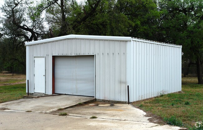


Property Detail
6871 S Interstate 35
44492
A0510BC G F LANKFORD, 17, ACRES 4.697
Commercialnec
Bell
B and X Area of moderate flood hazard, usually the area between the limits of the 100-year and 500-year floods.
Texas
2025
4.70 AC
2025
Outlying Bell County
023406
Killeen/Temple/Fort Hood
3,800 SF
Killeen-Temple, TX
NEARBY LISTINGS FOR SALE OR LEASE
DEMOGRAPHICS near 6871 S Interstate 35
1 mile
3 mile
5 mile
2024 Total Population
162
5,529
27,135
2029 Population
170
6,006
29,055
Pop Growth 2024-2029
+ 4.94%
+ 8.63%
+ 7.08%
Average Age
44
38
38
2024 Total Households
58
1,984
9,453
HH Growth 2024-2029
+ 5.17%
+ 8.62%
+ 7.27%
Median Household Inc
$124,999
$103,680
$87,828
Avg Household Size
2.70
2.80
2.70
2024 Avg HH Vehicles
3.00
2.00
2.00
Median Home Value
$562,500
$378,291
$345,066
Median Year Built
2001
2010
2004
Nearby Places
Map Layers
Map Styles
 Street
 Aerial
Transit
 Traffic
 Biking
Places
Listings with unknown addresses are not visible on the map
- Restaurants
- Banks
- Shops
- Fitness
- Groceries
PUBLIC TRANSPORTATION
AIRPORT
Killeen Municipal
Drive
Walk
Distance
Killeen Municipal
25 min
18.4 mi
Robert Gray AAF
Drive
Walk
Distance
Robert Gray AAF
44 min
32.3 mi
Nearby Properties
Address
Land Use
TOTAL SIZE
Lot Size
Zoning
Address
Land Use
TOTAL SIZE
Lot Size
Zoning
523,244 SF
74.89 AC
Address
Land Use
TOTAL SIZE
Lot Size
Zoning
39.79 AC
Address
Land Use
TOTAL SIZE
Lot Size
Zoning
85,530 SF
101.80 AC
Address
Land Use
TOTAL SIZE
Lot Size
Zoning
85,446 SF
25.88 AC
Address
Land Use
TOTAL SIZE
Lot Size
Zoning
40,089 SF
1.97 AC
Address
Land Use
TOTAL SIZE
Lot Size
Zoning
370.52 AC
Address
Land Use
TOTAL SIZE
Lot Size
Zoning
59,292 SF
9.05 AC
Address
Land Use
TOTAL SIZE
Lot Size
Zoning
7,143 SF
21.62 AC
Address
Land Use
TOTAL SIZE
Lot Size
Zoning
78,950 SF
10 AC
Address
Land Use
TOTAL SIZE
Lot Size
Zoning
17,099 SF
130.10 AC
Address
Land Use
TOTAL SIZE
Lot Size
Zoning
13,390 SF
20 AC
Address
Land Use
TOTAL SIZE
Lot Size
Zoning
25,370 SF
6.60 AC
Address
Land Use
TOTAL SIZE
Lot Size
Zoning
9,153 SF
5 AC
Address
Land Use
TOTAL SIZE
Lot Size
Zoning
40,020 SF
110.74 AC
1C
Address
Land Use
TOTAL SIZE
Lot Size
Zoning
3,198 SF
209.16 AC
Address
Land Use
TOTAL SIZE
Lot Size
Zoning
23,120 SF
20 AC
Address
Land Use
TOTAL SIZE
Lot Size
Zoning
120,975 SF
13.48 AC
Address
Land Use
TOTAL SIZE
Lot Size
Zoning
5,862 SF
660.53 AC
Address
Land Use
TOTAL SIZE
Lot Size
Zoning
6,317 SF
67.25 AC
Address
Land Use
TOTAL SIZE
Lot Size
Zoning
16,898 SF
2.51 AC
Address
Land Use
TOTAL SIZE
Lot Size
Zoning
34,926 SF
3.11 AC
Address
Land Use
TOTAL SIZE
Lot Size
Zoning
5,100 SF
10 AC
Address
Land Use
TOTAL SIZE
Lot Size
Zoning
7,294 SF
5.76 AC
Address
Land Use
TOTAL SIZE
Lot Size
Zoning
16,600 SF
329.60 AC
Address
Land Use
TOTAL SIZE
Lot Size
Zoning
27,512 SF
1.60 AC
Address
Land Use
TOTAL SIZE
Lot Size
Zoning
5,541 SF
30 AC
Address
Land Use
TOTAL SIZE
Lot Size
Zoning
7,473 SF
840.60 AC
Address
Land Use
TOTAL SIZE
Lot Size
Zoning
18,704 SF
196.93 AC
Address
Land Use
TOTAL SIZE
Lot Size
Zoning
5,710 SF
17.44 AC
Address
Land Use
TOTAL SIZE
Lot Size
Zoning
7,688 SF
75.38 AC
The World's #1 Commercial Real Estate Marketplace
Connect with us
© 2026 CoStar Group
The information above has been obtained from sources believed reliable. While we do not doubt its accuracy we have not verified it and make no guarantee, warranty or representation about it. It is your responsibility to independently confirm its accuracy and completeness. Any projections, opinions, assumptions, or estimates used are for example only and do not represent the current or future performance of the property. The value of this transaction to you depends on tax and other factors which should be evaluated by your tax, financial, and legal advisors. You and your advisors should conduct a careful, independent investigation of the property to determine to your satisfaction the suitability of the property for your needs.