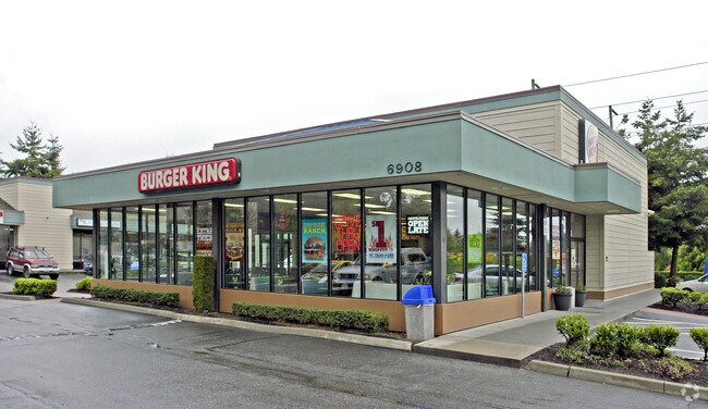
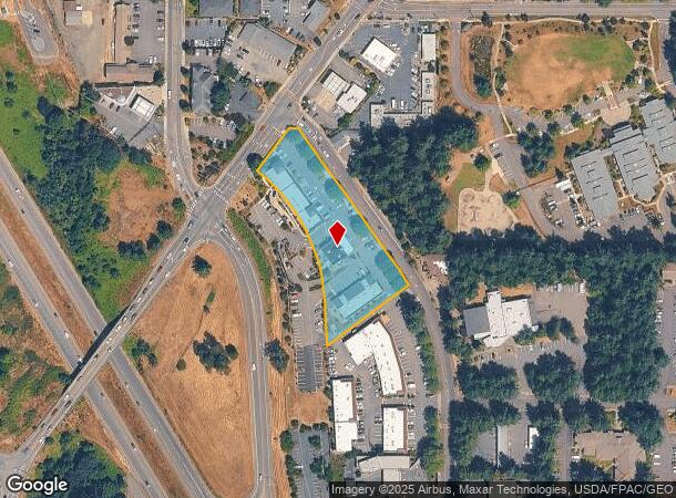
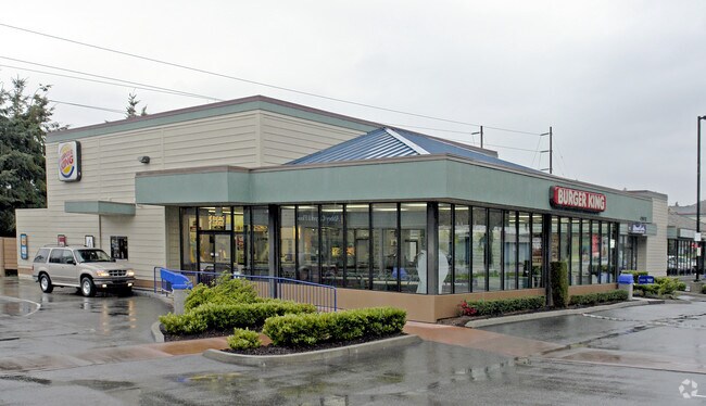
Property Record
6908 Kimball Dr, Gig Harbor, WA 98335
NEARBY LISTINGS FOR SALE OR LEASE
-
-
View all Gig Harbor listings for sale on LoopNet.com
Property Detail
6908 Kimball Dr
Seattle-Tacoma-Bellevue, WA
E Alg N Li Sd
022108-7024
SECTION 08 TOWNSHIP 21 RANGE 02 QUARTER 32 : TR A OF DBLR 85-01-18-0280 DESC AS FOLL PARCEL A DESC AS L 1 & 2 OF S P 84-02-10-0196 PARCEL B COM AT NW COR OF LOT 3 GIG HARBOR ABAND MILITARY RESERV TH E ALG N LI SD LOT 3 326.43 FT TO E R/W LI OF TAC CY
Regionalshoppingcenterormallwithanchorstore
Pierce
X
Washington
53033C1200G
3
2024
1.58 AC
2025
Gig Harbor/W Pierce Co
072507
Seattle/Puget Sound
16,409 SF
DEMOGRAPHICS near 6908 Kimball Dr
1 Mile
3 Mile
5 Mile
2024 Total Population
7,221
28,532
69,124
2029 Population
7,586
29,633
71,509
Pop Growth 2024-2029
+ 5.05%
+ 3.86%
+ 3.45%
Average Age
48
45
45
2024 Total Households
3,209
11,345
27,992
HH Growth 2024-2029
+ 4.92%
+ 3.87%
+ 3.54%
Median Household Inc
$109,790
$120,842
$117,634
Avg Household Size
2.20
2.40
2.40
2024 Avg HH Vehicles
2.00
2.00
2.00
Median Home Value
$707,263
$707,195
$701,757
Median Year Built
1988
1992
1987
Nearby Places
- Restaurants
- Banks
- Shops
- Fitness
- Groceries
PUBLIC TRANSPORTATION
AIRPORT
Seattle-Tacoma International
DRIVE
WALK
Distance
Seattle-Tacoma International
49 min
32.6 mi
Freight Ports
Port of Tacoma
DRIVE
WALK
Distance
Port of Tacoma
22 min
14.2 mi
Nearby Properties
Address
Land Use
TOTAL SIZE
Lot Size
Zoning
Address
Land Use
TOTAL SIZE
Lot Size
Zoning
427,880 SF
17.97 AC
GIGH
Address
Land Use
TOTAL SIZE
Lot Size
Zoning
189,797 SF
18.06 AC
RB-2
Address
Land Use
TOTAL SIZE
Lot Size
Zoning
318,450 SF
36.63 AC
ED
Address
Land Use
TOTAL SIZE
Lot Size
Zoning
132,295 SF
100.76 AC
UML
Address
Land Use
TOTAL SIZE
Lot Size
Zoning
184,782 SF
23.38 AC
B-2
Address
Land Use
TOTAL SIZE
Lot Size
Zoning
228,761 SF
4 AC
R10
Address
Land Use
TOTAL SIZE
Lot Size
Zoning
192,969 SF
11.52 AC
PRD
Address
Land Use
TOTAL SIZE
Lot Size
Zoning
321,717 SF
75.30 AC
PI
Address
Land Use
TOTAL SIZE
Lot Size
Zoning
297,754 SF
59.70 AC
PI
Address
Land Use
TOTAL SIZE
Lot Size
Zoning
166,830 SF
7.36 AC
Address
Land Use
TOTAL SIZE
Lot Size
Zoning
91,277 SF
5.08 AC
GIGH
Address
Land Use
TOTAL SIZE
Lot Size
Zoning
115,222 SF
27.53 AC
Address
Land Use
TOTAL SIZE
Lot Size
Zoning
123,138 SF
14.89 AC
RB-2
Address
Land Use
TOTAL SIZE
Lot Size
Zoning
106,293 SF
7.60 AC
Address
Land Use
TOTAL SIZE
Lot Size
Zoning
87,475 SF
11 AC
Address
Land Use
TOTAL SIZE
Lot Size
Zoning
71,494 SF
14.14 AC
Address
Land Use
TOTAL SIZE
Lot Size
Zoning
117,424 SF
24.84 AC
R-1
Address
Land Use
TOTAL SIZE
Lot Size
Zoning
129,455 SF
9.44 AC
RB-2
Address
Land Use
TOTAL SIZE
Lot Size
Zoning
151,391 SF
17.49 AC
PCD-C
Address
Land Use
TOTAL SIZE
Lot Size
Zoning
110,156 SF
9.54 AC
B-2
Address
Land Use
TOTAL SIZE
Lot Size
Zoning
104,043 SF
1.92 AC
B-2
Address
Land Use
TOTAL SIZE
Lot Size
Zoning
114,306 SF
6.54 AC
R-3
Address
Land Use
TOTAL SIZE
Lot Size
Zoning
83,169 SF
6.66 AC
B-2
Address
Land Use
TOTAL SIZE
Lot Size
Zoning
116,103 SF
4.14 AC
R10
Address
Land Use
TOTAL SIZE
Lot Size
Zoning
62,960 SF
5.41 AC
C-1
Address
Land Use
TOTAL SIZE
Lot Size
Zoning
122,520 SF
10.76 AC
PCD-C
Address
Land Use
TOTAL SIZE
Lot Size
Zoning
77,350 SF
9.07 AC
R10
Address
Land Use
TOTAL SIZE
Lot Size
Zoning
77,906 SF
5 AC
R-1
Address
Land Use
TOTAL SIZE
Lot Size
Zoning
78,124 SF
4.65 AC
R-3
Address
Land Use
TOTAL SIZE
Lot Size
Zoning
80,000 SF
9.17 AC
R10
The World's #1 Commercial Real Estate Marketplace
Connect with us
© 2025 CoStar Group
The information above has been obtained from sources believed reliable. While we do not doubt its accuracy we have not verified it and make no guarantee, warranty or representation about it. It is your responsibility to independently confirm its accuracy and completeness. Any projections, opinions, assumptions, or estimates used are for example only and do not represent the current or future performance of the property. The value of this transaction to you depends on tax and other factors which should be evaluated by your tax, financial, and legal advisors. You and your advisors should conduct a careful, independent investigation of the property to determine to your satisfaction the suitability of the property for your needs.