Property Record
6879 N Washoe Ave, Firebaugh, CA 93622
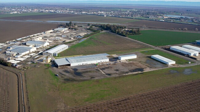
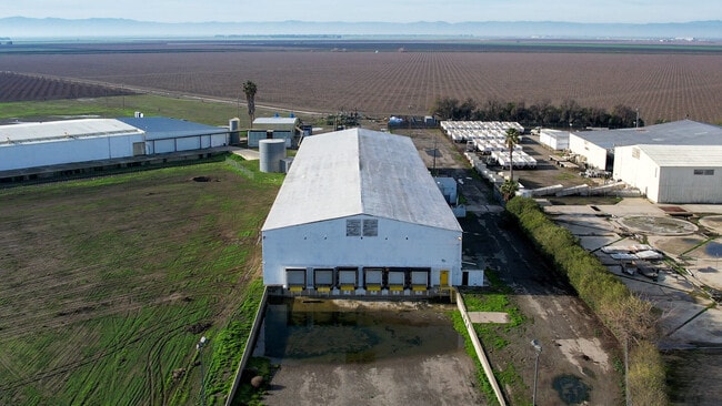
Property Detail
6879 N Washoe Ave
012-020-33
18.49 AC IN PAR 1 BK 15 PG 29 SEC 32 T12R14
Shipyard
FRESNO
AE20
California
B and X Area of moderate flood hazard, usually the area between the limits of the 100-year and 500-year floods.
19.23 AC
2025
W Outlying Fresno County
2025
Fresno
008405
Fresno, CA
45,300 SF
NEARBY LISTINGS FOR SALE OR LEASE
-
-
View all Firebaugh listings for sale on LoopNet.com
DEMOGRAPHICS near 6879 N Washoe Ave
1 mile
3 mile
5 mile
2025 Total Population
531
9,357
9,663
2030 Population
538
9,565
9,885
Pop Growth 2025-2030
+ 1.32%
+ 2.22%
+ 2.30%
Average Age
35
35
35
2025 Total Households
136
2,452
2,531
HH Growth 2025-2030
+ 1.47%
+ 2.20%
+ 2.25%
Median Household Inc
$44,999
$45,524
$45,495
Avg Household Size
4.00
3.80
3.80
2025 Avg HH Vehicles
2.00
2.00
2.00
Median Home Value
$335,294
$266,700
$267,268
Median Year Built
1982
1992
1992
Nearby Places
Map Layers
Map Styles
 Street
 Aerial
Layers
 Traffic
 Biking
Places
Listings with unknown addresses are not visible on the map
- Restaurants
- Banks
- Shops
- Fitness
- Groceries
SALE & LEASE HISTORY
LISTING DATE
SALE/LEASE

Jan 24, 2023
For Sale
Nearby Properties
Address
Land Use
TOTAL SIZE
Lot Size
Zoning
Address
Land Use
TOTAL SIZE
Lot Size
Zoning
426,760 SF
40 AC
M2
Address
Land Use
TOTAL SIZE
Lot Size
Zoning
800,520 SF
44.77 AC
AE20
Address
Land Use
TOTAL SIZE
Lot Size
Zoning
76,048 SF
3.51 AC
Address
Land Use
TOTAL SIZE
Lot Size
Zoning
105,096 SF
6.57 AC
R3
Address
Land Use
TOTAL SIZE
Lot Size
Zoning
23,160 SF
0.86 AC
R2
Address
Land Use
TOTAL SIZE
Lot Size
Zoning
46,203 SF
9.71 AC
M1
Address
Land Use
TOTAL SIZE
Lot Size
Zoning
58,080 SF
3.85 AC
R3
Address
Land Use
TOTAL SIZE
Lot Size
Zoning
1,286 SF
87.08 AC
AE20
Address
Land Use
TOTAL SIZE
Lot Size
Zoning
156,726 SF
28.12 AC
AE20
Address
Land Use
TOTAL SIZE
Lot Size
Zoning
52,669 SF
11.55 AC
M1
Address
Land Use
TOTAL SIZE
Lot Size
Zoning
102,450 SF
20 AC
AE20
Address
Land Use
TOTAL SIZE
Lot Size
Zoning
1,300 SF
427.12 AC
ARE-40
Address
Land Use
TOTAL SIZE
Lot Size
Zoning
102.26 AC
AE20
Address
Land Use
TOTAL SIZE
Lot Size
Zoning
11,657 SF
0.60 AC
C1
Address
Land Use
TOTAL SIZE
Lot Size
Zoning
40,504 SF
11.52 AC
A1
Address
Land Use
TOTAL SIZE
Lot Size
Zoning
2,466 SF
28.91 AC
AE20
Address
Land Use
TOTAL SIZE
Lot Size
Zoning
9,100 SF
1.11 AC
C3
Address
Land Use
TOTAL SIZE
Lot Size
Zoning
51,600 SF
1.72 AC
M1
Address
Land Use
TOTAL SIZE
Lot Size
Zoning
34,944 SF
2.76 AC
R3
Address
Land Use
TOTAL SIZE
Lot Size
Zoning
8,240 SF
0.69 AC
C3
Address
Land Use
TOTAL SIZE
Lot Size
Zoning
408 SF
333.63 AC
ARE-40
Address
Land Use
TOTAL SIZE
Lot Size
Zoning
27,700 SF
20.77 AC
AE20
Address
Land Use
TOTAL SIZE
Lot Size
Zoning
3,688 SF
307.70 AC
ARE-40
Address
Land Use
TOTAL SIZE
Lot Size
Zoning
4,403 SF
20.17 AC
AE20
Address
Land Use
TOTAL SIZE
Lot Size
Zoning
171,250 SF
34.71 AC
AE20
Address
Land Use
TOTAL SIZE
Lot Size
Zoning
15,945 SF
7.22 AC
R1
Address
Land Use
TOTAL SIZE
Lot Size
Zoning
11,000 SF
1.03 AC
C3
Address
Land Use
TOTAL SIZE
Lot Size
Zoning
1,376 SF
0.23 AC
C3
Address
Land Use
TOTAL SIZE
Lot Size
Zoning
9,901 SF
0.62 AC
R2
The World's #1 Commercial Real Estate Marketplace
Connect with us
© 2026 CoStar Group
The information above has been obtained from sources believed reliable. While we do not doubt its accuracy we have not verified it and make no guarantee, warranty or representation about it. It is your responsibility to independently confirm its accuracy and completeness. Any projections, opinions, assumptions, or estimates used are for example only and do not represent the current or future performance of the property. The value of this transaction to you depends on tax and other factors which should be evaluated by your tax, financial, and legal advisors. You and your advisors should conduct a careful, independent investigation of the property to determine to your satisfaction the suitability of the property for your needs.