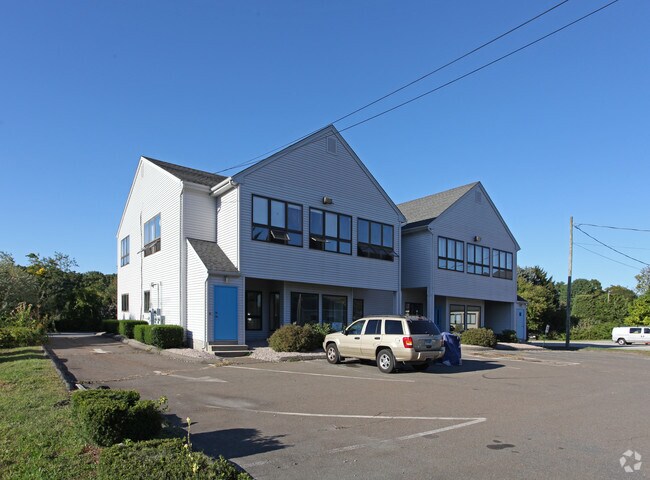
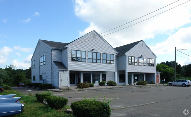
Property Record
688 Boston Post Rd, Westbrook, CT 06498

Current Lease Availabilities
Property Detail
688 Boston Post Rd
WBRO-000184-000000-000084
Lower Ct River Vly
Commercialbuilding
Connecticut
NCD
84
AE The base floodplain where base flood elevations are provided. AE Zones are now used on new format FIRMs instead of A1-A30 Zones.
0.72 AC
2025
SW Midlsx/Old Saybrk/Rt 9
2025
Hartford
680102
Hartford-West Hartford-East Hartford, CT
8,768 SF
NEARBY LISTINGS FOR SALE OR LEASE
DEMOGRAPHICS near 688 Boston Post Rd
1 mile
3 mile
5 mile
2025 Total Population
2,165
13,549
32,882
2030 Population
2,327
14,065
33,986
Pop Growth 2025-2030
+ 7.48%
+ 3.81%
+ 3.36%
Average Age
53
49
48
2025 Total Households
1,074
6,104
14,497
HH Growth 2025-2030
+ 7.64%
+ 4.28%
+ 3.68%
Median Household Inc
$72,448
$97,249
$104,396
Avg Household Size
2.00
2.10
2.20
2025 Avg HH Vehicles
2.00
2.00
2.00
Median Home Value
$675,572
$476,792
$468,458
Median Year Built
1965
1968
1969
Nearby Places
Map Layers
Map Styles
 Street
 Aerial
Transit
 Traffic
 Biking
Places
Listings with unknown addresses are not visible on the map
- Restaurants
- Banks
- Shops
- Fitness
- Groceries
PUBLIC TRANSPORTATION
COMMUTER RAIL
Drive
Walk
Distance
3 min
1.3 mi
Drive
Walk
Distance
8 min
3.7 mi
AIRPORT
Tweed/New Haven
Drive
Walk
Distance
Tweed/New Haven
34 min
24.6 mi
Freight Ports
Port of New Haven
Drive
Walk
Distance
Port of New Haven
35 min
25.2 mi
Nearby Properties
Address
Land Use
TOTAL SIZE
Lot Size
Zoning
Address
Land Use
TOTAL SIZE
Lot Size
Zoning
91,300 SF
8.03 AC
TIC
Address
Land Use
TOTAL SIZE
Lot Size
Zoning
159,832 SF
110.10 AC
RR
Address
Land Use
TOTAL SIZE
Lot Size
Zoning
14.87 AC
NCD
Address
Land Use
TOTAL SIZE
Lot Size
Zoning
39.32 AC
LI/LDR
Address
Land Use
TOTAL SIZE
Lot Size
Zoning
322.64 AC
RR/MDR
Address
Land Use
TOTAL SIZE
Lot Size
Zoning
624 SF
43.91 AC
CB
Address
Land Use
TOTAL SIZE
Lot Size
Zoning
14.78 AC
B-4
Address
Land Use
TOTAL SIZE
Lot Size
Zoning
46.69 AC
MDR
Address
Land Use
TOTAL SIZE
Lot Size
Zoning
49.71 AC
TIC
Address
Land Use
TOTAL SIZE
Lot Size
Zoning
81,335 SF
8.64 AC
B-4
Address
Land Use
TOTAL SIZE
Lot Size
Zoning
96,949 SF
11.52 AC
Address
Land Use
TOTAL SIZE
Lot Size
Zoning
15,446 SF
7.56 AC
B-2
Address
Land Use
TOTAL SIZE
Lot Size
Zoning
46,536 SF
3.62 AC
Address
Land Use
TOTAL SIZE
Lot Size
Zoning
35.50 AC
CB
Address
Land Use
TOTAL SIZE
Lot Size
Zoning
22,984 SF
6.58 AC
MDR
Address
Land Use
TOTAL SIZE
Lot Size
Zoning
25,144 SF
3.74 AC
B-4
Address
Land Use
TOTAL SIZE
Lot Size
Zoning
64,427 SF
1.46 AC
Address
Land Use
TOTAL SIZE
Lot Size
Zoning
85,800 SF
11.56 AC
LI/RR
Address
Land Use
TOTAL SIZE
Lot Size
Zoning
55,250 SF
4.41 AC
B-4
Address
Land Use
TOTAL SIZE
Lot Size
Zoning
11.70 AC
NCD
Address
Land Use
TOTAL SIZE
Lot Size
Zoning
24,632 SF
4.48 AC
LI
Address
Land Use
TOTAL SIZE
Lot Size
Zoning
32,752 SF
6.73 AC
TIC
Address
Land Use
TOTAL SIZE
Lot Size
Zoning
37,246 SF
25.83 AC
LDR
Address
Land Use
TOTAL SIZE
Lot Size
Zoning
13,448 SF
2.14 AC
B-4
Address
Land Use
TOTAL SIZE
Lot Size
Zoning
32,621 SF
3 AC
TIC
Address
Land Use
TOTAL SIZE
Lot Size
Zoning
45,402 SF
5.70 AC
A
Address
Land Use
TOTAL SIZE
Lot Size
Zoning
912 SF
6.63 AC
HDR/MD
Address
Land Use
TOTAL SIZE
Lot Size
Zoning
2.23 AC
MDR
Address
Land Use
TOTAL SIZE
Lot Size
Zoning
124.24 AC
R-30
Address
Land Use
TOTAL SIZE
Lot Size
Zoning
14,748 SF
1.57 AC
CTC
The World's #1 Commercial Real Estate Marketplace
Connect with us
© 2026 CoStar Group
The information above has been obtained from sources believed reliable. While we do not doubt its accuracy we have not verified it and make no guarantee, warranty or representation about it. It is your responsibility to independently confirm its accuracy and completeness. Any projections, opinions, assumptions, or estimates used are for example only and do not represent the current or future performance of the property. The value of this transaction to you depends on tax and other factors which should be evaluated by your tax, financial, and legal advisors. You and your advisors should conduct a careful, independent investigation of the property to determine to your satisfaction the suitability of the property for your needs.