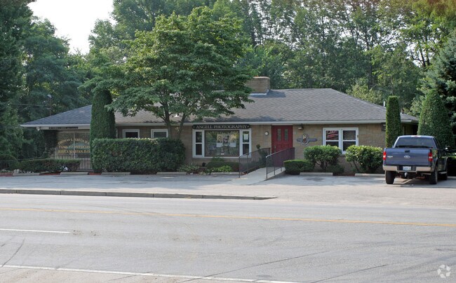
Property Record
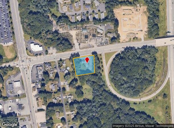
688 Frenchtown Rd, East Greenwich, RI 02818

NEARBY LISTINGS FOR SALE OR LEASE
Property Detail
688 Frenchtown Rd
EGRE-000029-000017-000040
Kent
Commercialbuilding
Rhode Island
X
40
44003C0138G
0.85 AC
2025
East Greenwich
2025
Providence
020903
Providence-Warwick, RI-MA
5,392 SF
DEMOGRAPHICS near 688 Frenchtown Rd
1 Mile
3 Mile
5 Mile
2024 Total Population
1,887
25,097
67,647
2029 Population
1,928
25,240
68,146
Pop Growth 2024-2029
+ 2.17%
+ 0.57%
+ 0.74%
Average Age
43
43
44
2024 Total Households
681
9,903
28,478
HH Growth 2024-2029
+ 2.06%
+ 0.25%
+ 0.65%
Median Household Inc
$54,500
$107,919
$86,898
Avg Household Size
2.70
2.50
2.30
2024 Avg HH Vehicles
2.00
2.00
2.00
Median Home Value
$432,692
$464,517
$393,882
Median Year Built
1977
1975
1973
Nearby Places
Map Layers
Map Styles
 Street
 Aerial
- Restaurants
- Banks
- Shops
- Fitness
- Groceries
PUBLIC TRANSPORTATION
COMMUTER RAIL
DRIVE
WALK
Distance
8 min
3.9 mi
DRIVE
WALK
Distance
14 min
8.8 mi
AIRPORT
Rhode Island Tf Green International
DRIVE
WALK
Distance
Rhode Island Tf Green International
20 min
10.7 mi
Freight Ports
Port of Davisville, RI
DRIVE
WALK
Distance
Port of Davisville, RI
12 min
5.3 mi
SALE & LEASE HISTORY
LISTING DATE
SALE/LEASE

Mar 29, 2022
For Lease
Mar 26, 2019
For Lease
Mar 02, 2023
For Lease
Nearby Properties
Address
Land Use
TOTAL SIZE
Lot Size
Zoning
Address
Land Use
TOTAL SIZE
Lot Size
Zoning
19.60 AC
CH
Address
Land Use
TOTAL SIZE
Lot Size
Zoning
83.30 AC
F1
Address
Land Use
TOTAL SIZE
Lot Size
Zoning
20.43 AC
MUPD
Address
Land Use
TOTAL SIZE
Lot Size
Zoning
541,370 SF
34.08 AC
CI
Address
Land Use
TOTAL SIZE
Lot Size
Zoning
8.10 AC
PR
Address
Land Use
TOTAL SIZE
Lot Size
Zoning
161,263 SF
61.75 AC
R30
Address
Land Use
TOTAL SIZE
Lot Size
Zoning
196,759 SF
33.67 AC
QBPD
Address
Land Use
TOTAL SIZE
Lot Size
Zoning
3,417 SF
7.13 AC
PR
Address
Land Use
TOTAL SIZE
Lot Size
Zoning
8.73 AC
PR
Address
Land Use
TOTAL SIZE
Lot Size
Zoning
63.69 AC
LI
Address
Land Use
TOTAL SIZE
Lot Size
Zoning
141,701 SF
12 AC
WJ
Address
Land Use
TOTAL SIZE
Lot Size
Zoning
107,212 SF
18.50 AC
R10
Address
Land Use
TOTAL SIZE
Lot Size
Zoning
137,323 SF
22.84 AC
PR
Address
Land Use
TOTAL SIZE
Lot Size
Zoning
97,308 SF
9.36 AC
P
Address
Land Use
TOTAL SIZE
Lot Size
Zoning
5.31 AC
M/LI
Address
Land Use
TOTAL SIZE
Lot Size
Zoning
83.12 AC
MLIO
Address
Land Use
TOTAL SIZE
Lot Size
Zoning
8.92 AC
PR
Address
Land Use
TOTAL SIZE
Lot Size
Zoning
9,216 SF
A7
Address
Land Use
TOTAL SIZE
Lot Size
Zoning
25.10 AC
QBPD
Address
Land Use
TOTAL SIZE
Lot Size
Zoning
12.68 AC
PR
Address
Land Use
TOTAL SIZE
Lot Size
Zoning
9.35 AC
PR
Address
Land Use
TOTAL SIZE
Lot Size
Zoning
8.85 AC
PR
Address
Land Use
TOTAL SIZE
Lot Size
Zoning
116,034 SF
10.65 AC
B
Address
Land Use
TOTAL SIZE
Lot Size
Zoning
15.90 AC
QBPD
Address
Land Use
TOTAL SIZE
Lot Size
Zoning
60,324 SF
4.39 AC
BP
Address
Land Use
TOTAL SIZE
Lot Size
Zoning
28.16 AC
B
Address
Land Use
TOTAL SIZE
Lot Size
Zoning
42,533 SF
12.60 AC
GB
Address
Land Use
TOTAL SIZE
Lot Size
Zoning
72,831 SF
2.98 AC
PR
Address
Land Use
TOTAL SIZE
Lot Size
Zoning
48,468 SF
4.50 AC
M/LI
Address
Land Use
TOTAL SIZE
Lot Size
Zoning
112,179 SF
13.45 AC
PR
The World's #1 Commercial Real Estate Marketplace
Connect with us
© 2025 CoStar Group
The information above has been obtained from sources believed reliable. While we do not doubt its accuracy we have not verified it and make no guarantee, warranty or representation about it. It is your responsibility to independently confirm its accuracy and completeness. Any projections, opinions, assumptions, or estimates used are for example only and do not represent the current or future performance of the property. The value of this transaction to you depends on tax and other factors which should be evaluated by your tax, financial, and legal advisors. You and your advisors should conduct a careful, independent investigation of the property to determine to your satisfaction the suitability of the property for your needs.