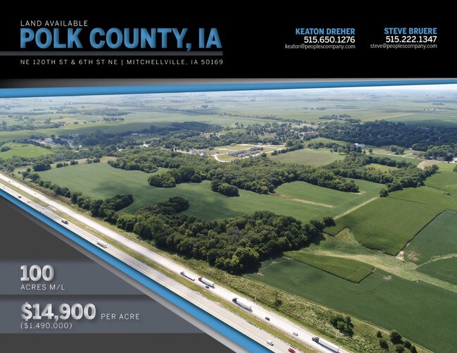
Property Record
6880 Ne 120Th St, Mitchellville, IA 50169


NEARBY LISTINGS FOR SALE OR LEASE
-
-
View all Mitchellville listings for sale on LoopNet.com
Property Detail
6880 Ne 120Th St
Des Moines-West Des Moines, IA
Sec 01-79-22
140-00001004001
-EX NE 1/4- NE FRL 1/4 LYG N OF INTST LESS RD SEC 1-79-22
Agriculturalland
Polk
X
Iowa
19153C0275F
110.63 AC
2024
Northeast
2025
Des Moines
010102
DEMOGRAPHICS near 6880 Ne 120Th St
1 Mile
3 Mile
5 Mile
2024 Total Population
1,193
3,209
5,631
2029 Population
1,284
3,474
6,080
Pop Growth 2024-2029
+ 7.63%
+ 8.26%
+ 7.97%
Average Age
39
39
39
2024 Total Households
346
930
1,789
HH Growth 2024-2029
+ 8.38%
+ 8.92%
+ 8.22%
Median Household Inc
$76,562
$83,259
$98,831
Avg Household Size
2.50
2.60
2.70
2024 Avg HH Vehicles
2.00
2.00
2.00
Median Home Value
$229,375
$243,540
$294,923
Median Year Built
1970
1971
1987
Nearby Places
Map Layers
Map Styles
 Street
 Aerial
- Restaurants
- Banks
- Shops
- Fitness
- Groceries
PUBLIC TRANSPORTATION
AIRPORT
Des Moines International
DRIVE
WALK
Distance
Des Moines International
34 min
23.4 mi
Freight Ports
Port Milwaukee
DRIVE
WALK
Distance
Port Milwaukee
396 min
358.0 mi
SALE & LEASE HISTORY
LISTING DATE
SALE/LEASE

May 30, 2019
For Sale
Nearby Properties
Address
Land Use
TOTAL SIZE
Lot Size
Zoning
Address
Land Use
TOTAL SIZE
Lot Size
Zoning
37,898 SF
28.28 AC
Address
Land Use
TOTAL SIZE
Lot Size
Zoning
15,589 SF
9.98 AC
Address
Land Use
TOTAL SIZE
Lot Size
Zoning
4,580 SF
1.16 AC
M-2
Address
Land Use
TOTAL SIZE
Lot Size
Zoning
46,286 SF
1.68 AC
Address
Land Use
TOTAL SIZE
Lot Size
Zoning
9,100 SF
1.29 AC
C-2
Address
Land Use
TOTAL SIZE
Lot Size
Zoning
3,360 SF
1.27 AC
C-2
Address
Land Use
TOTAL SIZE
Lot Size
Zoning
27,892 SF
1 AC
M-1
Address
Land Use
TOTAL SIZE
Lot Size
Zoning
13,320 SF
1.77 AC
R-3
Address
Land Use
TOTAL SIZE
Lot Size
Zoning
9,910 SF
0.50 AC
R-1
Address
Land Use
TOTAL SIZE
Lot Size
Zoning
7,802 SF
27.92 AC
AG
Address
Land Use
TOTAL SIZE
Lot Size
Zoning
8,434 SF
1.93 AC
C-2
Address
Land Use
TOTAL SIZE
Lot Size
Zoning
13,200 SF
2.26 AC
M-2
Address
Land Use
TOTAL SIZE
Lot Size
Zoning
6,060 SF
0.27 AC
C-4
Address
Land Use
TOTAL SIZE
Lot Size
Zoning
6,741 SF
0.42 AC
R-1
Address
Land Use
TOTAL SIZE
Lot Size
Zoning
5,840 SF
0.37 AC
C-4
Address
Land Use
TOTAL SIZE
Lot Size
Zoning
5,984 SF
0.20 AC
R-3
Address
Land Use
TOTAL SIZE
Lot Size
Zoning
5,280 SF
0.61 AC
R-3
Address
Land Use
TOTAL SIZE
Lot Size
Zoning
13,600 SF
2 AC
R-1
Address
Land Use
TOTAL SIZE
Lot Size
Zoning
4,352 SF
0.50 AC
R-3
Address
Land Use
TOTAL SIZE
Lot Size
Zoning
5,120 SF
0.39 AC
R-3
Address
Land Use
TOTAL SIZE
Lot Size
Zoning
5,120 SF
0.37 AC
R-3
Address
Land Use
TOTAL SIZE
Lot Size
Zoning
19,778 SF
2.05 AC
R-3
Address
Land Use
TOTAL SIZE
Lot Size
Zoning
5,656 SF
0.27 AC
R-1
Address
Land Use
TOTAL SIZE
Lot Size
Zoning
4,240 SF
0.25 AC
R-3
Address
Land Use
TOTAL SIZE
Lot Size
Zoning
18,801 SF
3.14 AC
R-3
Address
Land Use
TOTAL SIZE
Lot Size
Zoning
7,764 SF
0.50 AC
R-1
Address
Land Use
TOTAL SIZE
Lot Size
Zoning
1,144 SF
119.76 AC
Address
Land Use
TOTAL SIZE
Lot Size
Zoning
3,072 SF
0.27 AC
Address
Land Use
TOTAL SIZE
Lot Size
Zoning
4,640 SF
2.11 AC
Address
Land Use
TOTAL SIZE
Lot Size
Zoning
6,560 SF
0.92 AC
M-2
The World's #1 Commercial Real Estate Marketplace
Connect with us
© 2026 CoStar Group
The information above has been obtained from sources believed reliable. While we do not doubt its accuracy we have not verified it and make no guarantee, warranty or representation about it. It is your responsibility to independently confirm its accuracy and completeness. Any projections, opinions, assumptions, or estimates used are for example only and do not represent the current or future performance of the property. The value of this transaction to you depends on tax and other factors which should be evaluated by your tax, financial, and legal advisors. You and your advisors should conduct a careful, independent investigation of the property to determine to your satisfaction the suitability of the property for your needs.