Property Record
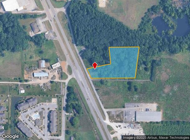
6887 Highway 431 S, Owens Cross Roads, AL 35763
NEARBY LISTINGS FOR SALE OR LEASE
Property Detail
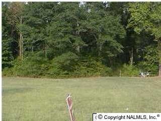
6887 Highway 431 S
Huntsville, AL
Sullivan Manor
18-07-36-0-000-005.000
PART OF LOT 1 SULLIVAN MANOR BEG AT NE COR OF LOT 1 TH S 06 DEG W 323.65 FT TO SE COR OF LOT 1 TH W ALG THE S LINE OF LOT 1 T
Commercialacreage
Madison
X
Alabama
01089C0363G
1
2025
2.70 AC
2025
South Madison County
010904
Huntsville
925 SF
DEMOGRAPHICS near 6887 Highway 431 S
1 Mile
3 Mile
5 Mile
2024 Total Population
3,395
19,792
50,441
2029 Population
3,748
21,779
55,527
Pop Growth 2024-2029
+ 10.40%
+ 10.04%
+ 10.08%
Average Age
38
40
43
2024 Total Households
1,187
7,362
19,899
HH Growth 2024-2029
+ 10.87%
+ 10.49%
+ 10.49%
Median Household Inc
$136,893
$122,966
$111,765
Avg Household Size
2.90
2.70
2.50
2024 Avg HH Vehicles
2.00
2.00
2.00
Median Home Value
$340,929
$356,970
$313,807
Median Year Built
2009
2003
1990
Nearby Places
Map Layers
Map Styles
 Street
 Aerial
- Restaurants
- Banks
- Shops
- Fitness
- Groceries
PUBLIC TRANSPORTATION
AIRPORT
Huntsville International-Carl T Jones Field
DRIVE
WALK
Distance
Huntsville International-Carl T Jones Field
35 min
22.7 mi
Freight Ports
Port of Mobile
DRIVE
WALK
Distance
Port of Mobile
402 min
363.9 mi
Nearby Properties
Address
Land Use
TOTAL SIZE
Lot Size
Zoning
Address
Land Use
TOTAL SIZE
Lot Size
Zoning
7,547 SF
22 AC
Address
Land Use
TOTAL SIZE
Lot Size
Zoning
2,932 SF
36.63 AC
Address
Land Use
TOTAL SIZE
Lot Size
Zoning
3,655 SF
10.75 AC
Address
Land Use
TOTAL SIZE
Lot Size
Zoning
183,823 SF
22.23 AC
Address
Land Use
TOTAL SIZE
Lot Size
Zoning
140,769 SF
14.48 AC
Address
Land Use
TOTAL SIZE
Lot Size
Zoning
70,096 SF
7.38 AC
Address
Land Use
TOTAL SIZE
Lot Size
Zoning
66,236 SF
11 AC
Address
Land Use
TOTAL SIZE
Lot Size
Zoning
Address
Land Use
TOTAL SIZE
Lot Size
Zoning
7,690 SF
75.26 AC
Address
Land Use
TOTAL SIZE
Lot Size
Zoning
64,700 SF
6.09 AC
Address
Land Use
TOTAL SIZE
Lot Size
Zoning
12,859 SF
8.38 AC
Address
Land Use
TOTAL SIZE
Lot Size
Zoning
1,710 SF
5.65 AC
Address
Land Use
TOTAL SIZE
Lot Size
Zoning
2,717 SF
6.12 AC
Address
Land Use
TOTAL SIZE
Lot Size
Zoning
Address
Land Use
TOTAL SIZE
Lot Size
Zoning
17,345 SF
4.28 AC
Address
Land Use
TOTAL SIZE
Lot Size
Zoning
4,200 SF
4 AC
Address
Land Use
TOTAL SIZE
Lot Size
Zoning
42,432 SF
7.71 AC
Address
Land Use
TOTAL SIZE
Lot Size
Zoning
13,000 SF
2.99 AC
Address
Land Use
TOTAL SIZE
Lot Size
Zoning
27,359 SF
2.72 AC
Address
Land Use
TOTAL SIZE
Lot Size
Zoning
15,219 SF
12 AC
Address
Land Use
TOTAL SIZE
Lot Size
Zoning
864 SF
98 AC
Address
Land Use
TOTAL SIZE
Lot Size
Zoning
9,958 SF
4.40 AC
Address
Land Use
TOTAL SIZE
Lot Size
Zoning
25.80 AC
Address
Land Use
TOTAL SIZE
Lot Size
Zoning
13,624 SF
2.01 AC
Address
Land Use
TOTAL SIZE
Lot Size
Zoning
Address
Land Use
TOTAL SIZE
Lot Size
Zoning
Address
Land Use
TOTAL SIZE
Lot Size
Zoning
15,015 SF
2.19 AC
Address
Land Use
TOTAL SIZE
Lot Size
Zoning
7,588 SF
21.77 AC
Address
Land Use
TOTAL SIZE
Lot Size
Zoning
10,540 SF
3.99 AC
Address
Land Use
TOTAL SIZE
Lot Size
Zoning
The World's #1 Commercial Real Estate Marketplace
Connect with us
© 2025 CoStar Group
The information above has been obtained from sources believed reliable. While we do not doubt its accuracy we have not verified it and make no guarantee, warranty or representation about it. It is your responsibility to independently confirm its accuracy and completeness. Any projections, opinions, assumptions, or estimates used are for example only and do not represent the current or future performance of the property. The value of this transaction to you depends on tax and other factors which should be evaluated by your tax, financial, and legal advisors. You and your advisors should conduct a careful, independent investigation of the property to determine to your satisfaction the suitability of the property for your needs.