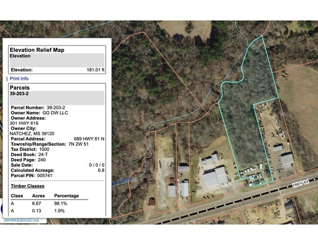
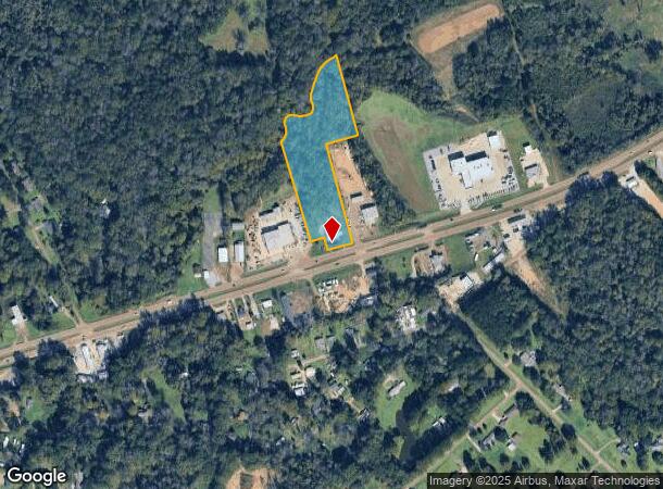
Property Record
689 Highway 61 N, Natchez, MS 39120
NEARBY LISTINGS FOR SALE OR LEASE
Property Detail
689 Highway 61 N
0188-0001-0003
LAND PT COONVILLE FARM MAP#39-203-2
Taxexempt
Adams
X
Mississippi
28001C0180D
6.40 AC
2024
Hattiesburg/South Area
2024
Other Market Areas
000500
Natchez, MS-LA
DEMOGRAPHICS near 689 Highway 61 N
1 Mile
3 Mile
5 Mile
2024 Total Population
553
7,102
18,766
2029 Population
519
6,700
17,927
Pop Growth 2024-2029
(6.15%)
(5.66%)
(4.47%)
Average Age
39
41
42
2024 Total Households
228
3,018
8,299
HH Growth 2024-2029
(5.70%)
(5.53%)
(4.27%)
Median Household Inc
$23,214
$32,795
$32,370
Avg Household Size
2.20
2.20
2.20
2024 Avg HH Vehicles
1.00
2.00
2.00
Median Home Value
$120,769
$76,389
$88,599
Median Year Built
1980
1974
1966
Nearby Places
- Restaurants
- Banks
- Shops
- Fitness
- Groceries
SALE & LEASE HISTORY
LISTING DATE
SALE/LEASE

Apr 25, 2023
For Sale
Nearby Properties
Address
Land Use
TOTAL SIZE
Lot Size
Zoning
Address
Land Use
TOTAL SIZE
Lot Size
Zoning
3,360 SF
18 AC
Address
Land Use
TOTAL SIZE
Lot Size
Zoning
11.10 AC
R4
Address
Land Use
TOTAL SIZE
Lot Size
Zoning
92,765 SF
6.36 AC
B4
Address
Land Use
TOTAL SIZE
Lot Size
Zoning
7,847 SF
4 AC
Address
Land Use
TOTAL SIZE
Lot Size
Zoning
4,514 SF
13.50 AC
R4
Address
Land Use
TOTAL SIZE
Lot Size
Zoning
11,694 SF
0.46 AC
B4
Address
Land Use
TOTAL SIZE
Lot Size
Zoning
2,624 SF
35 AC
R-2
Address
Land Use
TOTAL SIZE
Lot Size
Zoning
2,075 SF
6.79 AC
B4
Address
Land Use
TOTAL SIZE
Lot Size
Zoning
68,750 SF
6.32 AC
Address
Land Use
TOTAL SIZE
Lot Size
Zoning
14,985 SF
1.74 AC
B4
Address
Land Use
TOTAL SIZE
Lot Size
Zoning
7,821 SF
13.25 AC
R4
Address
Land Use
TOTAL SIZE
Lot Size
Zoning
20,656 SF
3.76 AC
B4
Address
Land Use
TOTAL SIZE
Lot Size
Zoning
5,736 SF
10 AC
Address
Land Use
TOTAL SIZE
Lot Size
Zoning
18,788 SF
3.07 AC
Address
Land Use
TOTAL SIZE
Lot Size
Zoning
9,372 SF
2.15 AC
B4
Address
Land Use
TOTAL SIZE
Lot Size
Zoning
10,786 SF
1.23 AC
B4
Address
Land Use
TOTAL SIZE
Lot Size
Zoning
3,750 SF
3.51 AC
Address
Land Use
TOTAL SIZE
Lot Size
Zoning
Address
Land Use
TOTAL SIZE
Lot Size
Zoning
6.68 AC
B4
Address
Land Use
TOTAL SIZE
Lot Size
Zoning
4,329 SF
2.22 AC
B4
Address
Land Use
TOTAL SIZE
Lot Size
Zoning
18,396 SF
0.24 AC
B4
Address
Land Use
TOTAL SIZE
Lot Size
Zoning
6,651 SF
11.50 AC
Address
Land Use
TOTAL SIZE
Lot Size
Zoning
3,600 SF
14.40 AC
Address
Land Use
TOTAL SIZE
Lot Size
Zoning
3,017 SF
1.25 AC
B4
Address
Land Use
TOTAL SIZE
Lot Size
Zoning
20,356 SF
1.13 AC
B4
Address
Land Use
TOTAL SIZE
Lot Size
Zoning
9,827 SF
2.17 AC
B4
Address
Land Use
TOTAL SIZE
Lot Size
Zoning
0.34 AC
B4
Address
Land Use
TOTAL SIZE
Lot Size
Zoning
7,334 SF
5.01 AC
B4
Address
Land Use
TOTAL SIZE
Lot Size
Zoning
3,290 SF
0.54 AC
Address
Land Use
TOTAL SIZE
Lot Size
Zoning
8,540 SF
1.14 AC
The World's #1 Commercial Real Estate Marketplace
Connect with us
© 2025 CoStar Group
The information above has been obtained from sources believed reliable. While we do not doubt its accuracy we have not verified it and make no guarantee, warranty or representation about it. It is your responsibility to independently confirm its accuracy and completeness. Any projections, opinions, assumptions, or estimates used are for example only and do not represent the current or future performance of the property. The value of this transaction to you depends on tax and other factors which should be evaluated by your tax, financial, and legal advisors. You and your advisors should conduct a careful, independent investigation of the property to determine to your satisfaction the suitability of the property for your needs.