Property Record
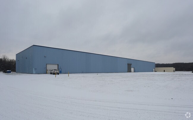
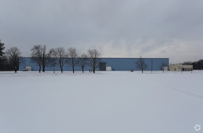
689 Mariaville Rd, Schenectady, NY 12306


NEARBY LISTINGS FOR SALE OR LEASE
-
-
View all Schenectady listings for sale on LoopNet.com
Property Detail
689 Mariaville Rd
047-000-0008-010-001-0000
Schenectady
Warehouse
New York
X
10.001
36001C0020D
14.45 AC
2025
Outer Schenectady County
2024
Albany/Schenectady/Troy
032601
Albany-Schenectady-Troy, NY
66,580 SF
DEMOGRAPHICS near 689 Mariaville Rd
1 Mile
3 Mile
5 Mile
2024 Total Population
2,342
25,648
91,643
2029 Population
2,457
27,044
96,119
Pop Growth 2024-2029
+ 4.91%
+ 5.44%
+ 4.88%
Average Age
42
41
40
2024 Total Households
1,067
10,991
38,234
HH Growth 2024-2029
+ 5.15%
+ 5.81%
+ 5.16%
Median Household Inc
$78,052
$77,179
$62,785
Avg Household Size
2.20
2.30
2.30
2024 Avg HH Vehicles
2.00
2.00
1.00
Median Home Value
$236,901
$181,354
$170,002
Median Year Built
1980
1955
1950
Nearby Places
Map Layers
Map Styles
 Street
 Aerial
- Restaurants
- Banks
- Shops
- Fitness
- Groceries
PUBLIC TRANSPORTATION
COMMUTER RAIL
DRIVE
WALK
Distance
12 min
7.8 mi
AIRPORT
Albany International
DRIVE
WALK
Distance
Albany International
31 min
19.0 mi
Freight Ports
Albany, NY Port
DRIVE
WALK
Distance
Albany, NY Port
38 min
26.5 mi
Nearby Properties
Address
Land Use
TOTAL SIZE
Lot Size
Zoning
Address
Land Use
TOTAL SIZE
Lot Size
Zoning
2,068,862 SF
204.52 AC
I-2
Address
Land Use
TOTAL SIZE
Lot Size
Zoning
1,003,413 SF
177.60 AC
B-1, I-1
Address
Land Use
TOTAL SIZE
Lot Size
Zoning
4,896 SF
12.80 AC
A-1
Address
Land Use
TOTAL SIZE
Lot Size
Zoning
128,744 SF
119 AC
A-1
Address
Land Use
TOTAL SIZE
Lot Size
Zoning
9.38 AC
I-2
Address
Land Use
TOTAL SIZE
Lot Size
Zoning
152,503 SF
8.21 AC
I-1
Address
Land Use
TOTAL SIZE
Lot Size
Zoning
21,791 SF
4.93 AC
B-1, B-2
Address
Land Use
TOTAL SIZE
Lot Size
Zoning
21,791 SF
4.86 AC
B-1, B-2
Address
Land Use
TOTAL SIZE
Lot Size
Zoning
12,289 SF
17.08 AC
R-3
Address
Land Use
TOTAL SIZE
Lot Size
Zoning
99.20 AC
Address
Land Use
TOTAL SIZE
Lot Size
Zoning
229,890 SF
85.08 AC
I-1
Address
Land Use
TOTAL SIZE
Lot Size
Zoning
127,632 SF
3.50 AC
B-1
Address
Land Use
TOTAL SIZE
Lot Size
Zoning
115,660 SF
12.37 AC
B-1
Address
Land Use
TOTAL SIZE
Lot Size
Zoning
230,000 SF
12.99 AC
I-1
Address
Land Use
TOTAL SIZE
Lot Size
Zoning
10,212 SF
7.09 AC
B-2
Address
Land Use
TOTAL SIZE
Lot Size
Zoning
2,450 SF
26.11 AC
R-3
Address
Land Use
TOTAL SIZE
Lot Size
Zoning
10,212 SF
5.97 AC
B-2
Address
Land Use
TOTAL SIZE
Lot Size
Zoning
10,212 SF
5.55 AC
B-2
Address
Land Use
TOTAL SIZE
Lot Size
Zoning
2,000 SF
22.12 AC
I-2
Address
Land Use
TOTAL SIZE
Lot Size
Zoning
263,100 SF
77.76 AC
I-1
Address
Land Use
TOTAL SIZE
Lot Size
Zoning
37,600 SF
7.11 AC
I-1
Address
Land Use
TOTAL SIZE
Lot Size
Zoning
18,706 SF
43.70 AC
A-1
Address
Land Use
TOTAL SIZE
Lot Size
Zoning
33,668 SF
3.88 AC
B-2
Address
Land Use
TOTAL SIZE
Lot Size
Zoning
18,000 SF
8.50 AC
I-1
Address
Land Use
TOTAL SIZE
Lot Size
Zoning
271,772 SF
26.20 AC
I-1
Address
Land Use
TOTAL SIZE
Lot Size
Zoning
4,281 SF
8.42 AC
R-3
Address
Land Use
TOTAL SIZE
Lot Size
Zoning
113.46 AC
Address
Land Use
TOTAL SIZE
Lot Size
Zoning
30,815 SF
1.11 AC
05 - COMME
Address
Land Use
TOTAL SIZE
Lot Size
Zoning
41,912 SF
3.80 AC
03 - MULTI
Address
Land Use
TOTAL SIZE
Lot Size
Zoning
45,270 SF
25.96 AC
R-1
The World's #1 Commercial Real Estate Marketplace
Connect with us
© 2025 CoStar Group
The information above has been obtained from sources believed reliable. While we do not doubt its accuracy we have not verified it and make no guarantee, warranty or representation about it. It is your responsibility to independently confirm its accuracy and completeness. Any projections, opinions, assumptions, or estimates used are for example only and do not represent the current or future performance of the property. The value of this transaction to you depends on tax and other factors which should be evaluated by your tax, financial, and legal advisors. You and your advisors should conduct a careful, independent investigation of the property to determine to your satisfaction the suitability of the property for your needs.