Property Record
6899 N Highway 1, Cocoa, FL 32927
NEARBY LISTINGS FOR SALE OR LEASE
-
-
View all Cocoa listings for sale on LoopNet.com
Property Detail
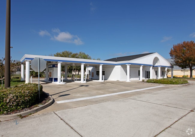
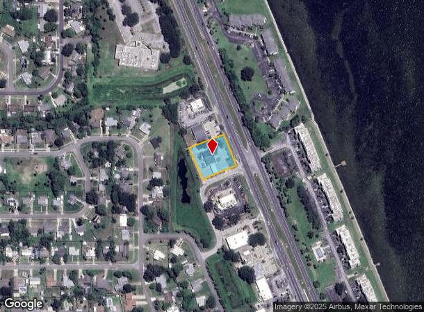
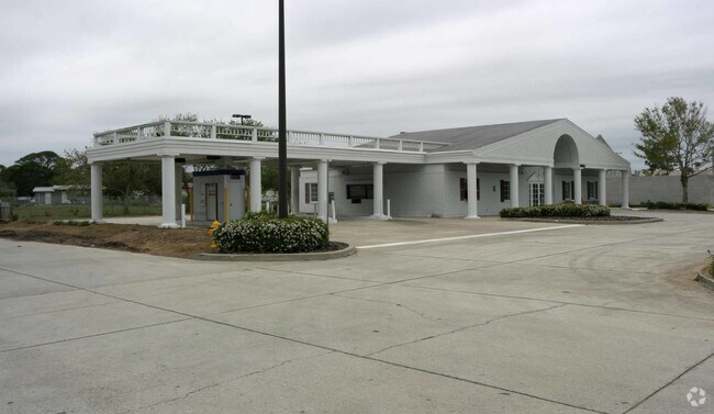
6899 N Highway 1
Palm Bay-Melbourne-Titusville, FL
Port St John Unit 1, Replat Of Pt Of Lot
23-36-18-BG-00018.0-0002.06
PORT ST JOHN UNIT 1, REPLAT OF PT OF LOTS 5,6 BLK 16 PT OF LOT 2 & PT OF TRACT F AS DESC IN ORB 3049 PG 1919 EXC ORB 3128 PG 4946, 3306 PG 3062, 3363 PG 2460
Financialbuilding
Brevard
X
Florida
12009C0310H
2
2024
0.78 AC
2025
Brevard County
062106
Orlando
4,313 SF
DEMOGRAPHICS near 6899 N Highway 1
1 Mile
3 Mile
5 Mile
2024 Total Population
4,226
22,371
39,936
2029 Population
4,588
24,247
43,372
Pop Growth 2024-2029
+ 8.57%
+ 8.39%
+ 8.60%
Average Age
43
42
43
2024 Total Households
1,800
8,887
15,799
HH Growth 2024-2029
+ 8.50%
+ 8.27%
+ 8.46%
Median Household Inc
$57,552
$67,675
$77,409
Avg Household Size
2.20
2.40
2.40
2024 Avg HH Vehicles
2.00
2.00
2.00
Median Home Value
$179,739
$217,788
$246,584
Median Year Built
1981
1986
1988
Nearby Places
Map Layers
Map Styles
 Street
 Aerial
- Restaurants
- Banks
- Shops
- Fitness
- Groceries
PUBLIC TRANSPORTATION
AIRPORT
Melbourne Orlando International
DRIVE
WALK
Distance
Melbourne Orlando International
50 min
35.1 mi
Freight Ports
Port Canaveral
DRIVE
WALK
Distance
Port Canaveral
21 min
14.5 mi
Nearby Properties
Address
Land Use
TOTAL SIZE
Lot Size
Zoning
Address
Land Use
TOTAL SIZE
Lot Size
Zoning
413,008 SF
127.62 AC
GMLH
Address
Land Use
TOTAL SIZE
Lot Size
Zoning
248,110 SF
12.77 AC
Address
Land Use
TOTAL SIZE
Lot Size
Zoning
203,226 SF
511.04 AC
P
Address
Land Use
TOTAL SIZE
Lot Size
Zoning
105,543 SF
16.08 AC
RU19
Address
Land Use
TOTAL SIZE
Lot Size
Zoning
73,476 SF
31.58 AC
BU1
Address
Land Use
TOTAL SIZE
Lot Size
Zoning
141,221 SF
85 AC
IU
Address
Land Use
TOTAL SIZE
Lot Size
Zoning
96,436 SF
19.10 AC
RU19
Address
Land Use
TOTAL SIZE
Lot Size
Zoning
48,555 SF
42.28 AC
IU
Address
Land Use
TOTAL SIZE
Lot Size
Zoning
63,083 SF
18.93 AC
GU
Address
Land Use
TOTAL SIZE
Lot Size
Zoning
95,535 SF
12.69 AC
AU
Address
Land Use
TOTAL SIZE
Lot Size
Zoning
65,645 SF
107.50 AC
GML
Address
Land Use
TOTAL SIZE
Lot Size
Zoning
89,772 SF
10.12 AC
BU1
Address
Land Use
TOTAL SIZE
Lot Size
Zoning
83,661 SF
15.08 AC
PID
Address
Land Use
TOTAL SIZE
Lot Size
Zoning
92,647 SF
7.02 AC
BU-2
Address
Land Use
TOTAL SIZE
Lot Size
Zoning
42,936 SF
27.69 AC
GU
Address
Land Use
TOTAL SIZE
Lot Size
Zoning
59,557 SF
7.28 AC
BU1
Address
Land Use
TOTAL SIZE
Lot Size
Zoning
73,134 SF
9 AC
PIP
Address
Land Use
TOTAL SIZE
Lot Size
Zoning
24,151 SF
4.62 AC
GML-H
Address
Land Use
TOTAL SIZE
Lot Size
Zoning
21,820 SF
4.32 AC
BU1
Address
Land Use
TOTAL SIZE
Lot Size
Zoning
60,075 SF
3.55 AC
P
Address
Land Use
TOTAL SIZE
Lot Size
Zoning
36,712 SF
1.80 AC
BU1
Address
Land Use
TOTAL SIZE
Lot Size
Zoning
19,580 SF
19.95 AC
RU24
Address
Land Use
TOTAL SIZE
Lot Size
Zoning
184.43 AC
IU
Address
Land Use
TOTAL SIZE
Lot Size
Zoning
15,873 SF
2.02 AC
BU-1
Address
Land Use
TOTAL SIZE
Lot Size
Zoning
39,430 SF
2.09 AC
Address
Land Use
TOTAL SIZE
Lot Size
Zoning
7,454 SF
24.95 AC
GML
Address
Land Use
TOTAL SIZE
Lot Size
Zoning
16,014 SF
1.62 AC
BU1
Address
Land Use
TOTAL SIZE
Lot Size
Zoning
1,730 SF
4.10 AC
GML
Address
Land Use
TOTAL SIZE
Lot Size
Zoning
20,615 SF
6 AC
INL
Address
Land Use
TOTAL SIZE
Lot Size
Zoning
17,360 SF
3.11 AC
GML
The World's #1 Commercial Real Estate Marketplace
Connect with us
© 2025 CoStar Group
The information above has been obtained from sources believed reliable. While we do not doubt its accuracy we have not verified it and make no guarantee, warranty or representation about it. It is your responsibility to independently confirm its accuracy and completeness. Any projections, opinions, assumptions, or estimates used are for example only and do not represent the current or future performance of the property. The value of this transaction to you depends on tax and other factors which should be evaluated by your tax, financial, and legal advisors. You and your advisors should conduct a careful, independent investigation of the property to determine to your satisfaction the suitability of the property for your needs.