Property Record
6899 Navarre Pky, Navarre, FL 32566


NEARBY LISTINGS FOR SALE OR LEASE
-
-
View all Navarre listings for lease on LoopNet.com
Property Detail
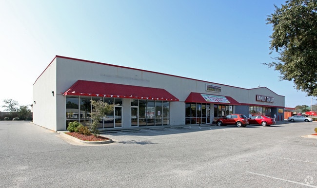
6899 Navarre Pky
23-2S-27-0000-01601-0000
Dummy Plat (*** Do Not Post ** This Is A
Storebuilding
*DESC IN MORE DETAIL FOR 2015* COM I/S OF SLY R/W LI HWY 98 & E LI OF W2 OF SW4 OF SEC 23 THN N89*2553W ALNG R/W 1140 FT TO W R/W SEA LARK LN & POB THN S00*5229W ALNG R/W 200 FT THN N89*2553W 270 FT THN N00*5229E 200 FT TO TH AFORE SAID R/W OF HWY 98
X
Santa Rosa
12113C0568H
Florida
2024
1 AC
2025
Navarre
010824
Pensacola
14,250 SF
Pensacola-Ferry Pass-Brent, FL
DEMOGRAPHICS near 6899 Navarre Pky
1 Mile
3 Mile
5 Mile
2024 Total Population
3,729
27,157
51,043
2029 Population
4,259
31,396
59,284
Pop Growth 2024-2029
+ 14.21%
+ 15.61%
+ 16.15%
Average Age
39
40
40
2024 Total Households
1,334
10,173
19,429
HH Growth 2024-2029
+ 14.62%
+ 16.08%
+ 16.72%
Median Household Inc
$104,460
$93,652
$92,507
Avg Household Size
2.80
2.60
2.60
2024 Avg HH Vehicles
2.00
2.00
2.00
Median Home Value
$305,378
$316,788
$320,758
Median Year Built
2003
2004
2002
Nearby Places
Map Layers
Map Styles
 Street
 Aerial
- Restaurants
- Banks
- Shops
- Fitness
- Groceries
PUBLIC TRANSPORTATION
AIRPORT
Pensacola International
DRIVE
WALK
Distance
Pensacola International
45 min
25.7 mi
Eglin AFB/Destin-Ft Walton Beach
DRIVE
WALK
Distance
Eglin AFB/Destin-Ft Walton Beach
58 min
30.5 mi
Freight Ports
Port of Mobile
DRIVE
WALK
Distance
Port of Mobile
98 min
81.6 mi
SALE & LEASE HISTORY
LISTING DATE
SALE/LEASE

Jan 31, 2023
For Lease
Nearby Properties
Address
Land Use
TOTAL SIZE
Lot Size
Zoning
Address
Land Use
TOTAL SIZE
Lot Size
Zoning
1.03 AC
NONE
Address
Land Use
TOTAL SIZE
Lot Size
Zoning
344,974 SF
16.11 AC
R3
Address
Land Use
TOTAL SIZE
Lot Size
Zoning
375,552 SF
10.62 AC
PBD
Address
Land Use
TOTAL SIZE
Lot Size
Zoning
242,842 SF
14.77 AC
PBD
Address
Land Use
TOTAL SIZE
Lot Size
Zoning
241,693 SF
14.28 AC
PBD
Address
Land Use
TOTAL SIZE
Lot Size
Zoning
161,438 SF
5.64 AC
HCD
Address
Land Use
TOTAL SIZE
Lot Size
Zoning
68,134 SF
21.16 AC
R1
Address
Land Use
TOTAL SIZE
Lot Size
Zoning
116,452 SF
4.55 AC
HCD
Address
Land Use
TOTAL SIZE
Lot Size
Zoning
65,936 SF
1.86 AC
PBD
Address
Land Use
TOTAL SIZE
Lot Size
Zoning
51,677 SF
17.79 AC
PBD
Address
Land Use
TOTAL SIZE
Lot Size
Zoning
85,562 SF
36.21 AC
PBD
Address
Land Use
TOTAL SIZE
Lot Size
Zoning
19,350 SF
9.10 AC
HCD
Address
Land Use
TOTAL SIZE
Lot Size
Zoning
60,854 SF
7.07 AC
HCD
Address
Land Use
TOTAL SIZE
Lot Size
Zoning
48,198 SF
1.76 AC
PBD
Address
Land Use
TOTAL SIZE
Lot Size
Zoning
130,030 SF
36.74 AC
R1A
Address
Land Use
TOTAL SIZE
Lot Size
Zoning
39,373 SF
185.18 AC
R1
Address
Land Use
TOTAL SIZE
Lot Size
Zoning
73,433 SF
33.98 AC
HCD
Address
Land Use
TOTAL SIZE
Lot Size
Zoning
24,565 SF
17.03 AC
HCD
Address
Land Use
TOTAL SIZE
Lot Size
Zoning
40,963 SF
8.36 AC
HCD
Address
Land Use
TOTAL SIZE
Lot Size
Zoning
10,506 SF
0.67 AC
PBD
Address
Land Use
TOTAL SIZE
Lot Size
Zoning
41.24 AC
R1
Address
Land Use
TOTAL SIZE
Lot Size
Zoning
19.59 AC
HCD
Address
Land Use
TOTAL SIZE
Lot Size
Zoning
20,150 SF
4.02 AC
HCD
Address
Land Use
TOTAL SIZE
Lot Size
Zoning
17,056 SF
4.17 AC
HCD
The World's #1 Commercial Real Estate Marketplace
Connect with us
© 2026 CoStar Group
The information above has been obtained from sources believed reliable. While we do not doubt its accuracy we have not verified it and make no guarantee, warranty or representation about it. It is your responsibility to independently confirm its accuracy and completeness. Any projections, opinions, assumptions, or estimates used are for example only and do not represent the current or future performance of the property. The value of this transaction to you depends on tax and other factors which should be evaluated by your tax, financial, and legal advisors. You and your advisors should conduct a careful, independent investigation of the property to determine to your satisfaction the suitability of the property for your needs.