Property Record
69 Baptist Church Rd, Hampton, NJ 08827
NEARBY LISTINGS FOR SALE OR LEASE
Property Detail
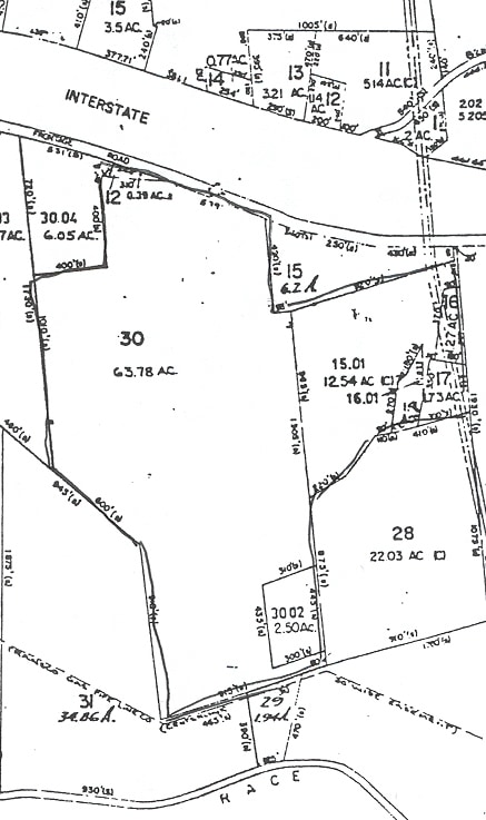
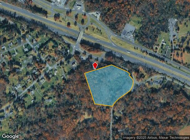
69 Baptist Church Rd
25-00014-0000-00016-0000-Q0009
Hunterdon
Farms
New Jersey
X
16
34019C0113F
11.60 AC
2024
Hunterdon
2025
Northern New Jersey
010701
Newark, NJ-PA
DEMOGRAPHICS near 69 Baptist Church Rd
1 Mile
3 Mile
5 Mile
2024 Total Population
806
6,552
21,732
2029 Population
812
6,588
21,928
Pop Growth 2024-2029
+ 0.74%
+ 0.55%
+ 0.90%
Average Age
44
45
44
2024 Total Households
291
1,988
7,840
HH Growth 2024-2029
+ 0.69%
+ 1.01%
+ 1.14%
Median Household Inc
$117,543
$127,617
$118,586
Avg Household Size
2.80
2.80
2.50
2024 Avg HH Vehicles
2.00
2.00
2.00
Median Home Value
$406,667
$472,107
$425,612
Median Year Built
1968
1977
1977
Nearby Places
Map Layers
Map Styles
 Street
 Aerial
- Restaurants
- Banks
- Shops
- Fitness
- Groceries
PUBLIC TRANSPORTATION
COMMUTER RAIL
Annandale (Raritan Valley Line - NJ Transit Commuter Rail (NJ Transit))
DRIVE
WALK
Distance
Annandale (Raritan Valley Line - NJ Transit Commuter Rail (NJ Transit))
10 min
7.1 mi
High Bridge (Raritan Valley Line - NJ Transit Commuter Rail (NJ Transit))
DRIVE
WALK
Distance
High Bridge (Raritan Valley Line - NJ Transit Commuter Rail (NJ Transit))
11 min
7.8 mi
AIRPORT
Lehigh Valley International
DRIVE
WALK
Distance
Lehigh Valley International
43 min
27.6 mi
Trenton Mercer
DRIVE
WALK
Distance
Trenton Mercer
53 min
35.7 mi
Freight Ports
New York Container Terminal
DRIVE
WALK
Distance
New York Container Terminal
66 min
51.1 mi
Nearby Properties
Address
Land Use
TOTAL SIZE
Lot Size
Zoning
Address
Land Use
TOTAL SIZE
Lot Size
Zoning
500.58 AC
WM
Address
Land Use
TOTAL SIZE
Lot Size
Zoning
255.40 AC
WM
Address
Land Use
TOTAL SIZE
Lot Size
Zoning
2.27 AC
OR1
Address
Land Use
TOTAL SIZE
Lot Size
Zoning
3,205 SF
22.05 AC
CR
Address
Land Use
TOTAL SIZE
Lot Size
Zoning
151.92 AC
INS
Address
Land Use
TOTAL SIZE
Lot Size
Zoning
157.99 AC
INS
Address
Land Use
TOTAL SIZE
Lot Size
Zoning
2.40 AC
OR1
Address
Land Use
TOTAL SIZE
Lot Size
Zoning
1,120 SF
103 AC
INS
Address
Land Use
TOTAL SIZE
Lot Size
Zoning
12.60 AC
VR
Address
Land Use
TOTAL SIZE
Lot Size
Zoning
4,948 SF
354.37 AC
CR
Address
Land Use
TOTAL SIZE
Lot Size
Zoning
9.05 AC
MR
Address
Land Use
TOTAL SIZE
Lot Size
Zoning
71.36 AC
INS
Address
Land Use
TOTAL SIZE
Lot Size
Zoning
800 SF
28.04 AC
MR
Address
Land Use
TOTAL SIZE
Lot Size
Zoning
11.75 AC
PO
Address
Land Use
TOTAL SIZE
Lot Size
Zoning
1,392 SF
5.89 AC
PC
Address
Land Use
TOTAL SIZE
Lot Size
Zoning
5.17 AC
Q
Address
Land Use
TOTAL SIZE
Lot Size
Zoning
54.31 AC
INS
Address
Land Use
TOTAL SIZE
Lot Size
Zoning
4.19 AC
VC
Address
Land Use
TOTAL SIZE
Lot Size
Zoning
8.58 AC
PC
Address
Land Use
TOTAL SIZE
Lot Size
Zoning
6.53 AC
PC
Address
Land Use
TOTAL SIZE
Lot Size
Zoning
5.27 AC
PO
Address
Land Use
TOTAL SIZE
Lot Size
Zoning
34,410 SF
10.01 AC
PC
Address
Land Use
TOTAL SIZE
Lot Size
Zoning
14.70 AC
MFG
Address
Land Use
TOTAL SIZE
Lot Size
Zoning
4,107 SF
10.19 AC
PC
Address
Land Use
TOTAL SIZE
Lot Size
Zoning
32.98 AC
INS
Address
Land Use
TOTAL SIZE
Lot Size
Zoning
29,456 SF
12.18 AC
VC
Address
Land Use
TOTAL SIZE
Lot Size
Zoning
0.71 AC
OR1
Address
Land Use
TOTAL SIZE
Lot Size
Zoning
5,528 SF
1.23 AC
HR
Address
Land Use
TOTAL SIZE
Lot Size
Zoning
153.13 AC
MR
Address
Land Use
TOTAL SIZE
Lot Size
Zoning
29,534 SF
81.22 AC
The World's #1 Commercial Real Estate Marketplace
Connect with us
© 2025 CoStar Group
The information above has been obtained from sources believed reliable. While we do not doubt its accuracy we have not verified it and make no guarantee, warranty or representation about it. It is your responsibility to independently confirm its accuracy and completeness. Any projections, opinions, assumptions, or estimates used are for example only and do not represent the current or future performance of the property. The value of this transaction to you depends on tax and other factors which should be evaluated by your tax, financial, and legal advisors. You and your advisors should conduct a careful, independent investigation of the property to determine to your satisfaction the suitability of the property for your needs.