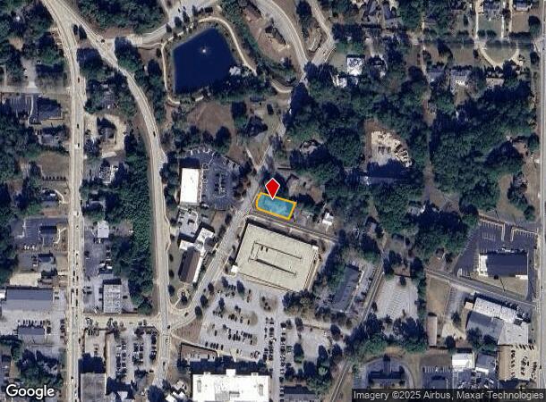
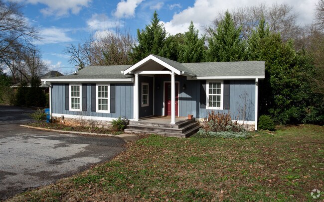
Property Record
69 Lawrenceville St, Mcdonough, GA 30253

NEARBY LISTINGS FOR SALE OR LEASE
Property Detail
69 Lawrenceville St
Atlanta-Sandy Springs-Roswell, GA
Henry
0M19-06-017-001
Georgia
Sfr
0.18 AC
X
South Clayton/Henry Cnty
13151C0159D
Atlanta
1,264 SF
DEMOGRAPHICS near 69 Lawrenceville St
1 Mile
3 Mile
5 Mile
2024 Total Population
5,719
46,006
90,275
2029 Population
6,283
50,510
99,052
Pop Growth 2024-2029
+ 9.86%
+ 9.79%
+ 9.72%
Average Age
39
37
37
2024 Total Households
2,185
16,497
31,568
HH Growth 2024-2029
+ 9.79%
+ 9.88%
+ 9.85%
Median Household Inc
$56,313
$71,096
$79,178
Avg Household Size
2.60
2.70
2.80
2024 Avg HH Vehicles
2.00
2.00
2.00
Median Home Value
$234,026
$233,165
$251,721
Median Year Built
2002
2002
2002
Nearby Places
Map Layers
Map Styles
 Street
 Aerial
- Restaurants
- Banks
- Shops
- Fitness
- Groceries
PUBLIC TRANSPORTATION
AIRPORT
Hartsfield - Jackson Atlanta International
DRIVE
WALK
Distance
Hartsfield - Jackson Atlanta International
34 min
24.1 mi
SALE & LEASE HISTORY
LISTING DATE
SALE/LEASE

Jun 14, 2017
For Sale
Nearby Properties
Address
Land Use
TOTAL SIZE
Lot Size
Zoning
Address
Land Use
TOTAL SIZE
Lot Size
Zoning
33,565 SF
44.68 AC
Address
Land Use
TOTAL SIZE
Lot Size
Zoning
3,973,920 SF
88.41 AC
I
Address
Land Use
TOTAL SIZE
Lot Size
Zoning
1,226,687 SF
100.81 AC
M2
Address
Land Use
TOTAL SIZE
Lot Size
Zoning
10,092 SF
46.06 AC
RM
Address
Land Use
TOTAL SIZE
Lot Size
Zoning
29,768 SF
50.81 AC
RM
Address
Land Use
TOTAL SIZE
Lot Size
Zoning
27,336 SF
27.95 AC
Address
Land Use
TOTAL SIZE
Lot Size
Zoning
2,337,242 SF
71.11 AC
M2
Address
Land Use
TOTAL SIZE
Lot Size
Zoning
21,880 SF
22.04 AC
RMH
Address
Land Use
TOTAL SIZE
Lot Size
Zoning
59,445 SF
20.17 AC
PD
Address
Land Use
TOTAL SIZE
Lot Size
Zoning
6,422 SF
24.67 AC
RM
Address
Land Use
TOTAL SIZE
Lot Size
Zoning
1,588,692 SF
44.95 AC
M1
Address
Land Use
TOTAL SIZE
Lot Size
Zoning
11,256 SF
34.51 AC
RM
Address
Land Use
TOTAL SIZE
Lot Size
Zoning
40,500 SF
27.66 AC
RA
Address
Land Use
TOTAL SIZE
Lot Size
Zoning
6,344 SF
21.40 AC
C1
Address
Land Use
TOTAL SIZE
Lot Size
Zoning
25,622 SF
17.43 AC
RMH
Address
Land Use
TOTAL SIZE
Lot Size
Zoning
1,456,864 SF
82.62 AC
Address
Land Use
TOTAL SIZE
Lot Size
Zoning
2,877,520 SF
53.73 AC
C2
Address
Land Use
TOTAL SIZE
Lot Size
Zoning
23,400 SF
29 AC
RM
Address
Land Use
TOTAL SIZE
Lot Size
Zoning
40,246 SF
13.73 AC
Address
Land Use
TOTAL SIZE
Lot Size
Zoning
498,160 SF
44.14 AC
M1
Address
Land Use
TOTAL SIZE
Lot Size
Zoning
532,585 SF
67.79 AC
M2
Address
Land Use
TOTAL SIZE
Lot Size
Zoning
3,114 SF
15.44 AC
RM
Address
Land Use
TOTAL SIZE
Lot Size
Zoning
63,279 SF
52.18 AC
C1
Address
Land Use
TOTAL SIZE
Lot Size
Zoning
997,015 SF
153.75 AC
M1
Address
Land Use
TOTAL SIZE
Lot Size
Zoning
429,447 SF
40.07 AC
M2
Address
Land Use
TOTAL SIZE
Lot Size
Zoning
5,104 SF
42.40 AC
Address
Land Use
TOTAL SIZE
Lot Size
Zoning
93,935 SF
157.31 AC
M1
Address
Land Use
TOTAL SIZE
Lot Size
Zoning
9,501 SF
23.57 AC
M1
Address
Land Use
TOTAL SIZE
Lot Size
Zoning
906,860 SF
3.58 AC
M1
Address
Land Use
TOTAL SIZE
Lot Size
Zoning
249,826 SF
18.42 AC
M1
The World's #1 Commercial Real Estate Marketplace
Connect with us
© 2025 CoStar Group
The information above has been obtained from sources believed reliable. While we do not doubt its accuracy we have not verified it and make no guarantee, warranty or representation about it. It is your responsibility to independently confirm its accuracy and completeness. Any projections, opinions, assumptions, or estimates used are for example only and do not represent the current or future performance of the property. The value of this transaction to you depends on tax and other factors which should be evaluated by your tax, financial, and legal advisors. You and your advisors should conduct a careful, independent investigation of the property to determine to your satisfaction the suitability of the property for your needs.