Property Record
69 Lippincott Rd, Wallkill, NY 12589
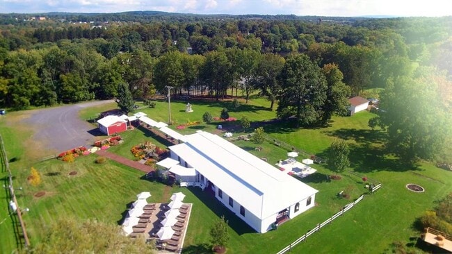
This Property Is For Sale
NEARBY LISTINGS FOR SALE OR LEASE
-
-
View all Wallkill listings for sale on LoopNet.com
Property Detail
69 Lippincott Rd
5200-106.001-0002-013.000-0000
Ulster
Sfr
New York
AE
27.200
36111C0855E
3.55 AC
2025
Hudson Valley Area
2024
Other Market Areas
955400
Kingston, NY
3,040 SF
DEMOGRAPHICS near 69 Lippincott Rd
1 Mile
3 Mile
5 Mile
2024 Total Population
1,152
6,321
24,165
2029 Population
1,115
6,248
24,177
Pop Growth 2024-2029
(3.21%)
(1.15%)
+ 0.05%
Average Age
41
43
41
2024 Total Households
441
1,966
8,241
HH Growth 2024-2029
(3.17%)
(1.63%)
+ 0.01%
Median Household Inc
$81,798
$96,143
$97,195
Avg Household Size
2.60
2.60
2.70
2024 Avg HH Vehicles
2.00
2.00
2.00
Median Home Value
$311,065
$323,267
$321,687
Median Year Built
1970
1976
1974
Nearby Places
Map Layers
Map Styles
 Street
 Aerial
- Restaurants
- Banks
- Shops
- Fitness
- Groceries
PUBLIC TRANSPORTATION
AIRPORT
New York Stewart International
DRIVE
WALK
Distance
New York Stewart International
25 min
14.6 mi
Freight Ports
Port Newark Container Terminal
DRIVE
WALK
Distance
Port Newark Container Terminal
109 min
80.7 mi
Nearby Properties
Address
Land Use
TOTAL SIZE
Lot Size
Zoning
Address
Land Use
TOTAL SIZE
Lot Size
Zoning
14,376 SF
63.90 AC
01
Address
Land Use
TOTAL SIZE
Lot Size
Zoning
18,386 SF
54.70 AC
RA-.5
Address
Land Use
TOTAL SIZE
Lot Size
Zoning
38.80 AC
H-1
Address
Land Use
TOTAL SIZE
Lot Size
Zoning
100.90 AC
RAG-2
Address
Land Use
TOTAL SIZE
Lot Size
Zoning
84.40 AC
RA-.5
Address
Land Use
TOTAL SIZE
Lot Size
Zoning
92,537 SF
3.80 AC
H-1
Address
Land Use
TOTAL SIZE
Lot Size
Zoning
93.10 AC
RA-.5
Address
Land Use
TOTAL SIZE
Lot Size
Zoning
63,710 SF
26.30 AC
H-1
Address
Land Use
TOTAL SIZE
Lot Size
Zoning
2,520 SF
45.90 AC
B4
Address
Land Use
TOTAL SIZE
Lot Size
Zoning
7,605 SF
1 AC
AG1.5
Address
Land Use
TOTAL SIZE
Lot Size
Zoning
Address
Land Use
TOTAL SIZE
Lot Size
Zoning
16,742 SF
1.40 AC
RA-.5
Address
Land Use
TOTAL SIZE
Lot Size
Zoning
2,450 SF
1.60 AC
B4
Address
Land Use
TOTAL SIZE
Lot Size
Zoning
2,304 SF
130 AC
RA-.5
Address
Land Use
TOTAL SIZE
Lot Size
Zoning
10,680 SF
4.50 AC
I3
Address
Land Use
TOTAL SIZE
Lot Size
Zoning
44,629 SF
27.20 AC
I3
Address
Land Use
TOTAL SIZE
Lot Size
Zoning
5.80 AC
HWG
Address
Land Use
TOTAL SIZE
Lot Size
Zoning
19,873 SF
0.74 AC
SB
Address
Land Use
TOTAL SIZE
Lot Size
Zoning
5,101 SF
8.20 AC
RA-.5
Address
Land Use
TOTAL SIZE
Lot Size
Zoning
2,464 SF
154.40 AC
RA5
Address
Land Use
TOTAL SIZE
Lot Size
Zoning
8,700 SF
5 AC
B4
Address
Land Use
TOTAL SIZE
Lot Size
Zoning
4,423 SF
27.90 AC
RA-.5
Address
Land Use
TOTAL SIZE
Lot Size
Zoning
2,992 SF
0.06 AC
RM
Address
Land Use
TOTAL SIZE
Lot Size
Zoning
59,374 SF
2.30 AC
SB
Address
Land Use
TOTAL SIZE
Lot Size
Zoning
567.70 AC
RAG-4
Address
Land Use
TOTAL SIZE
Lot Size
Zoning
16,686 SF
2.40 AC
SB
Address
Land Use
TOTAL SIZE
Lot Size
Zoning
6.30 AC
RAG-1
Address
Land Use
TOTAL SIZE
Lot Size
Zoning
8,427 SF
0.01 AC
B4
Address
Land Use
TOTAL SIZE
Lot Size
Zoning
5,383 SF
64.50 AC
RA5
Address
Land Use
TOTAL SIZE
Lot Size
Zoning
2,703 SF
3.80 AC
B4
The World's #1 Commercial Real Estate Marketplace
Connect with us
© 2026 CoStar Group
The information above has been obtained from sources believed reliable. While we do not doubt its accuracy we have not verified it and make no guarantee, warranty or representation about it. It is your responsibility to independently confirm its accuracy and completeness. Any projections, opinions, assumptions, or estimates used are for example only and do not represent the current or future performance of the property. The value of this transaction to you depends on tax and other factors which should be evaluated by your tax, financial, and legal advisors. You and your advisors should conduct a careful, independent investigation of the property to determine to your satisfaction the suitability of the property for your needs.