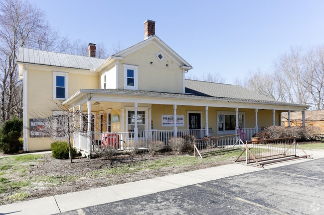
Property Record
69 Maple St, Waynesville, OH 45068


NEARBY LISTINGS FOR SALE OR LEASE
-
-
View all Waynesville listings for lease on LoopNet.com
Property Detail
69 Maple St
Cincinnati, OH-KY-IN
Johnsons Add.
10-36-151-014
JOHNSONS ADD. LOT 12
Commercialnec
Warren
AE
Ohio
39165C0064F
12
2024
0.25 AC
2024
Outlying Warren County
031002
Cincinnati/Dayton
2,608 SF
DEMOGRAPHICS near 69 Maple St
1 mile
3 mile
5 mile
2024 Total Population
1,945
5,753
12,916
2029 Population
2,071
6,146
13,829
Pop Growth 2024-2029
+ 6.48%
+ 6.83%
+ 7.07%
Average Age
43
43
41
2024 Total Households
774
2,239
4,710
HH Growth 2024-2029
+ 6.59%
+ 6.88%
+ 7.01%
Median Household Inc
$84,466
$82,888
$93,225
Avg Household Size
2.50
2.50
2.70
2024 Avg HH Vehicles
2.00
2.00
2.00
Median Home Value
$262,777
$281,721
$320,037
Median Year Built
1973
1980
1984
Nearby Places
Map Layers
Map Styles
 Street
 Aerial
Transit
 Traffic
 Biking
Places
Listings with unknown addresses are not visible on the map
- Restaurants
- Banks
- Shops
- Fitness
- Groceries
PUBLIC TRANSPORTATION
AIRPORT
James M Cox Dayton International
Drive
Walk
Distance
James M Cox Dayton International
54 min
37.0 mi
SALE & LEASE HISTORY
LISTING DATE
SALE/LEASE

Feb 21, 2017
For Lease
Feb 21, 2017
For Sale
Nearby Properties
Address
Land Use
TOTAL SIZE
Lot Size
Zoning
Address
Land Use
TOTAL SIZE
Lot Size
Zoning
21,852 SF
2,092.67 AC
Address
Land Use
TOTAL SIZE
Lot Size
Zoning
67,563 SF
9.93 AC
Address
Land Use
TOTAL SIZE
Lot Size
Zoning
120,300 SF
7.50 AC
Address
Land Use
TOTAL SIZE
Lot Size
Zoning
82,817 SF
8.34 AC
Address
Land Use
TOTAL SIZE
Lot Size
Zoning
2,760 SF
12.56 AC
Address
Land Use
TOTAL SIZE
Lot Size
Zoning
6,408 SF
375.64 AC
Address
Land Use
TOTAL SIZE
Lot Size
Zoning
14,691 SF
305.25 AC
Address
Land Use
TOTAL SIZE
Lot Size
Zoning
10,616 SF
114.60 AC
Address
Land Use
TOTAL SIZE
Lot Size
Zoning
13,160 SF
18.99 AC
Address
Land Use
TOTAL SIZE
Lot Size
Zoning
30,786 SF
5 AC
Address
Land Use
TOTAL SIZE
Lot Size
Zoning
8,273 SF
50.03 AC
Address
Land Use
TOTAL SIZE
Lot Size
Zoning
11.08 AC
Address
Land Use
TOTAL SIZE
Lot Size
Zoning
8,438 SF
26.01 AC
Address
Land Use
TOTAL SIZE
Lot Size
Zoning
17,540 SF
1.57 AC
Address
Land Use
TOTAL SIZE
Lot Size
Zoning
14,874 SF
3.69 AC
Address
Land Use
TOTAL SIZE
Lot Size
Zoning
17,120 SF
70.78 AC
Address
Land Use
TOTAL SIZE
Lot Size
Zoning
18,274 SF
2.85 AC
Address
Land Use
TOTAL SIZE
Lot Size
Zoning
22,156 SF
6.18 AC
Address
Land Use
TOTAL SIZE
Lot Size
Zoning
5.91 AC
Address
Land Use
TOTAL SIZE
Lot Size
Zoning
5,858 SF
44.83 AC
Address
Land Use
TOTAL SIZE
Lot Size
Zoning
8,672 SF
28.49 AC
Address
Land Use
TOTAL SIZE
Lot Size
Zoning
221 SF
373.64 AC
Address
Land Use
TOTAL SIZE
Lot Size
Zoning
1,782 SF
5.64 AC
Address
Land Use
TOTAL SIZE
Lot Size
Zoning
1,168 SF
5.52 AC
Address
Land Use
TOTAL SIZE
Lot Size
Zoning
6,147 SF
6.64 AC
Address
Land Use
TOTAL SIZE
Lot Size
Zoning
9,666 SF
19.88 AC
Address
Land Use
TOTAL SIZE
Lot Size
Zoning
10,011 SF
2.19 AC
Address
Land Use
TOTAL SIZE
Lot Size
Zoning
6,960 SF
9.99 AC
Address
Land Use
TOTAL SIZE
Lot Size
Zoning
6,042 SF
4.64 AC
Address
Land Use
TOTAL SIZE
Lot Size
Zoning
170.37 AC
The World's #1 Commercial Real Estate Marketplace
Connect with us
© 2026 CoStar Group
The information above has been obtained from sources believed reliable. While we do not doubt its accuracy we have not verified it and make no guarantee, warranty or representation about it. It is your responsibility to independently confirm its accuracy and completeness. Any projections, opinions, assumptions, or estimates used are for example only and do not represent the current or future performance of the property. The value of this transaction to you depends on tax and other factors which should be evaluated by your tax, financial, and legal advisors. You and your advisors should conduct a careful, independent investigation of the property to determine to your satisfaction the suitability of the property for your needs.