Property Record
69 Princeton Hightstown Rd, East Windsor, NJ 08520

This Property Is For Sale
NEARBY LISTINGS FOR SALE OR LEASE
-
-
View all East Windsor listings for sale on LoopNet.com
Property Detail
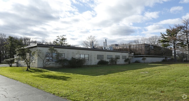
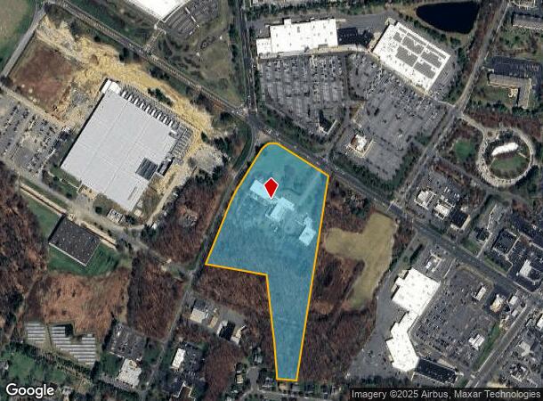
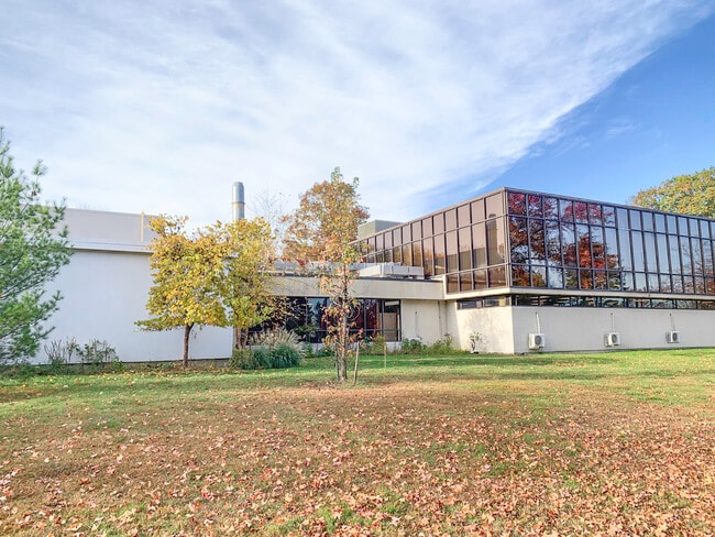
69 Princeton Hightstown Rd
01-00063-01-00001
Mercer
Scientificpharmaceuticalmedicalresearchfacility
New Jersey
X
1
34021C0168F
15.07 AC
2024
Princeton
2025
Northern New Jersey
004406
Trenton, NJ
38,178 SF
DEMOGRAPHICS near 69 Princeton Hightstown Rd
1 Mile
3 Mile
5 Mile
2024 Total Population
7,941
37,699
93,029
2029 Population
7,680
37,110
92,229
Pop Growth 2024-2029
(3.29%)
(1.56%)
(0.86%)
Average Age
43
42
41
2024 Total Households
3,172
13,858
34,463
HH Growth 2024-2029
(3.59%)
(1.81%)
(1.06%)
Median Household Inc
$91,265
$109,566
$123,965
Avg Household Size
2.50
2.70
2.60
2024 Avg HH Vehicles
2.00
2.00
2.00
Median Home Value
$318,304
$378,818
$478,591
Median Year Built
1978
1977
1983
Nearby Places
- Restaurants
- Banks
- Shops
- Fitness
- Groceries
PUBLIC TRANSPORTATION
COMMUTER RAIL
Princeton Junction (Northeast Corridor Line - NJ Transit Commuter Rail (NJ Transit), Princeton Branch - NJ Transit Commuter Rail (NJ Transit))
DRIVE
WALK
Distance
Princeton Junction (Northeast Corridor Line - NJ Transit Commuter Rail (NJ Transit), Princeton Branch - NJ Transit Commuter Rail (NJ Transit))
11 min
6.0 mi
Princeton (Princeton Branch - NJ Transit Commuter Rail (NJ Transit))
DRIVE
WALK
Distance
Princeton (Princeton Branch - NJ Transit Commuter Rail (NJ Transit))
16 min
8.6 mi
AIRPORT
Trenton Mercer
DRIVE
WALK
Distance
Trenton Mercer
31 min
20.2 mi
Freight Ports
New York Container Terminal
DRIVE
WALK
Distance
New York Container Terminal
50 min
36.9 mi
Nearby Properties
Address
Land Use
TOTAL SIZE
Lot Size
Zoning
Address
Land Use
TOTAL SIZE
Lot Size
Zoning
203.85 AC
I/LI
Address
Land Use
TOTAL SIZE
Lot Size
Zoning
57.09 AC
R-1
Address
Land Use
TOTAL SIZE
Lot Size
Zoning
2,448 SF
59.55 AC
RO
Address
Land Use
TOTAL SIZE
Lot Size
Zoning
110.44 AC
OW
Address
Land Use
TOTAL SIZE
Lot Size
Zoning
115.37 AC
I/LI
Address
Land Use
TOTAL SIZE
Lot Size
Zoning
51.01 AC
RO
Address
Land Use
TOTAL SIZE
Lot Size
Zoning
47.51 AC
I/LI
Address
Land Use
TOTAL SIZE
Lot Size
Zoning
318,155 SF
36.28 AC
RO
Address
Land Use
TOTAL SIZE
Lot Size
Zoning
376,379 SF
81.40 AC
PRC
Address
Land Use
TOTAL SIZE
Lot Size
Zoning
606,000 SF
51.49 AC
PUD
Address
Land Use
TOTAL SIZE
Lot Size
Zoning
567,798 SF
134.06 AC
RO
Address
Land Use
TOTAL SIZE
Lot Size
Zoning
12.30 AC
R-1
Address
Land Use
TOTAL SIZE
Lot Size
Zoning
27.57 AC
PUD
Address
Land Use
TOTAL SIZE
Lot Size
Zoning
186,785 SF
29.83 AC
HC
Address
Land Use
TOTAL SIZE
Lot Size
Zoning
243,700 SF
34.78 AC
HC
Address
Land Use
TOTAL SIZE
Lot Size
Zoning
23.60 AC
R1
Address
Land Use
TOTAL SIZE
Lot Size
Zoning
161,588 SF
28 AC
RO
Address
Land Use
TOTAL SIZE
Lot Size
Zoning
53.56 AC
I/LI
Address
Land Use
TOTAL SIZE
Lot Size
Zoning
281,154 SF
39.34 AC
RO
Address
Land Use
TOTAL SIZE
Lot Size
Zoning
36.99 AC
R-1
Address
Land Use
TOTAL SIZE
Lot Size
Zoning
15.55 AC
B-2
Address
Land Use
TOTAL SIZE
Lot Size
Zoning
22.13 AC
PUD
Address
Land Use
TOTAL SIZE
Lot Size
Zoning
153,230 SF
12.30 AC
HC
Address
Land Use
TOTAL SIZE
Lot Size
Zoning
26.65 AC
R-2
Address
Land Use
TOTAL SIZE
Lot Size
Zoning
107,069 SF
16.02 AC
HC
Address
Land Use
TOTAL SIZE
Lot Size
Zoning
8.93 AC
PUD
Address
Land Use
TOTAL SIZE
Lot Size
Zoning
22.47 AC
RO
Address
Land Use
TOTAL SIZE
Lot Size
Zoning
21.81 AC
RO
Address
Land Use
TOTAL SIZE
Lot Size
Zoning
38.54 AC
OW
Address
Land Use
TOTAL SIZE
Lot Size
Zoning
25.53 AC
I/LI
The World's #1 Commercial Real Estate Marketplace
Connect with us
© 2025 CoStar Group
The information above has been obtained from sources believed reliable. While we do not doubt its accuracy we have not verified it and make no guarantee, warranty or representation about it. It is your responsibility to independently confirm its accuracy and completeness. Any projections, opinions, assumptions, or estimates used are for example only and do not represent the current or future performance of the property. The value of this transaction to you depends on tax and other factors which should be evaluated by your tax, financial, and legal advisors. You and your advisors should conduct a careful, independent investigation of the property to determine to your satisfaction the suitability of the property for your needs.