Property Record
690 Depot St, North Easton, MA 02356

NEARBY LISTINGS FOR SALE OR LEASE
Property Detail
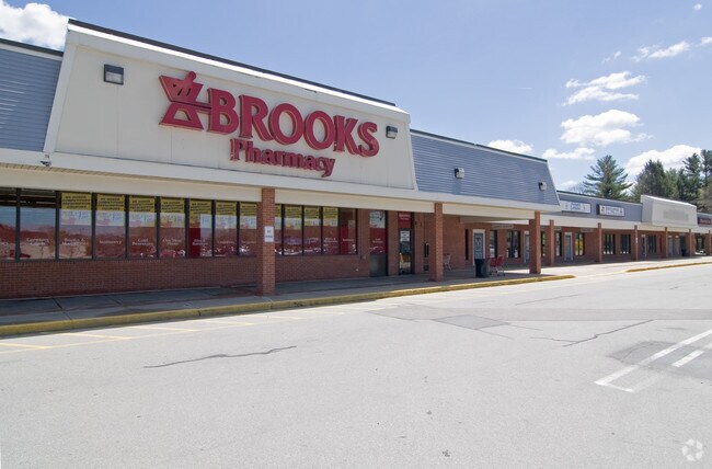
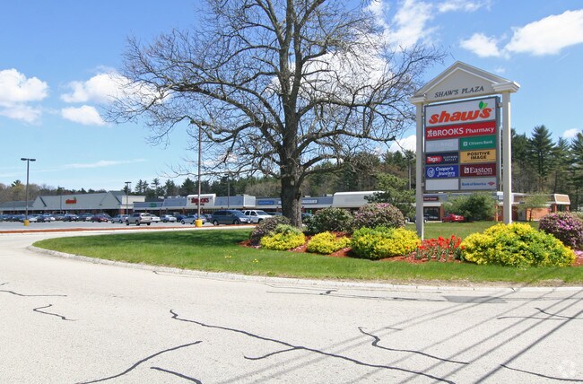
690 Depot St
Regionalshoppingcenterormallwithanchorstore
Bristol
X
Massachusetts
25023C0175J
19.83 AC
2025
Attleboro/New Bedford
2025
Boston
600204
Providence-Warwick, RI-MA
103,765 SF
EAST-000045U-000047A
DEMOGRAPHICS near 690 Depot St
1 Mile
3 Mile
5 Mile
2024 Total Population
3,064
24,191
61,650
2029 Population
3,068
24,168
61,378
Pop Growth 2024-2029
+ 0.13%
(0.10%)
(0.44%)
Average Age
42
42
41
2024 Total Households
1,094
8,938
21,718
HH Growth 2024-2029
+ 0.09%
(0.04%)
(0.39%)
Median Household Inc
$153,043
$118,161
$118,601
Avg Household Size
2.80
2.60
2.70
2024 Avg HH Vehicles
2.00
2.00
2.00
Median Home Value
$599,494
$506,187
$499,650
Median Year Built
1980
1979
1978
Nearby Places
Map Layers
Map Styles
 Street
 Aerial
- Restaurants
- Banks
- Shops
- Fitness
- Groceries
PUBLIC TRANSPORTATION
COMMUTER RAIL
Mansfield (Foxboro Line (Special Events Only) - Massachusetts Bay Transportation Authority Commuter Rail (Purple Line), Providence/Stoughton Line - Massachusetts Bay Transportation Authority Commuter Rail (Purple Line))
DRIVE
WALK
Distance
Mansfield (Foxboro Line (Special Events Only) - Massachusetts Bay Transportation Authority Commuter Rail (Purple Line), Providence/Stoughton Line - Massachusetts Bay Transportation Authority Commuter Rail (Purple Line))
13 min
6.0 mi
Brockton (Middleborough/Lakeville Line - Massachusetts Bay Transportation Authority Commuter Rail (Purple Line))
DRIVE
WALK
Distance
Brockton (Middleborough/Lakeville Line - Massachusetts Bay Transportation Authority Commuter Rail (Purple Line))
15 min
7.3 mi
AIRPORT
General Edward Lawrence Logan International
DRIVE
WALK
Distance
General Edward Lawrence Logan International
45 min
30.6 mi
Rhode Island Tf Green International
DRIVE
WALK
Distance
Rhode Island Tf Green International
55 min
33.2 mi
Freight Ports
Port of Boston
DRIVE
WALK
Distance
Port of Boston
43 min
28.4 mi
Nearby Properties
Address
Land Use
TOTAL SIZE
Lot Size
Zoning
Address
Land Use
TOTAL SIZE
Lot Size
Zoning
20.33 AC
Address
Land Use
TOTAL SIZE
Lot Size
Zoning
216,489 SF
49.60 AC
Address
Land Use
TOTAL SIZE
Lot Size
Zoning
22.56 AC
Address
Land Use
TOTAL SIZE
Lot Size
Zoning
270,179 SF
51 AC
Address
Land Use
TOTAL SIZE
Lot Size
Zoning
225,600 SF
18.47 AC
R80
Address
Land Use
TOTAL SIZE
Lot Size
Zoning
97,262 SF
6.46 AC
Address
Land Use
TOTAL SIZE
Lot Size
Zoning
145,360 SF
11.80 AC
Address
Land Use
TOTAL SIZE
Lot Size
Zoning
Address
Land Use
TOTAL SIZE
Lot Size
Zoning
105,664 SF
13.16 AC
Address
Land Use
TOTAL SIZE
Lot Size
Zoning
129,261 SF
12.87 AC
Address
Land Use
TOTAL SIZE
Lot Size
Zoning
101,871 SF
82.25 AC
Address
Land Use
TOTAL SIZE
Lot Size
Zoning
79,958 SF
2.90 AC
Address
Land Use
TOTAL SIZE
Lot Size
Zoning
7.50 AC
Address
Land Use
TOTAL SIZE
Lot Size
Zoning
15.28 AC
Address
Land Use
TOTAL SIZE
Lot Size
Zoning
2.50 AC
Address
Land Use
TOTAL SIZE
Lot Size
Zoning
40,755 SF
2.62 AC
Address
Land Use
TOTAL SIZE
Lot Size
Zoning
49,671 SF
3.02 AC
Address
Land Use
TOTAL SIZE
Lot Size
Zoning
6.10 AC
Address
Land Use
TOTAL SIZE
Lot Size
Zoning
39,527 SF
5.20 AC
Address
Land Use
TOTAL SIZE
Lot Size
Zoning
60,000 SF
22.76 AC
Address
Land Use
TOTAL SIZE
Lot Size
Zoning
81,374 SF
5.48 AC
Address
Land Use
TOTAL SIZE
Lot Size
Zoning
6.09 AC
Address
Land Use
TOTAL SIZE
Lot Size
Zoning
41,257 SF
13 AC
Address
Land Use
TOTAL SIZE
Lot Size
Zoning
31,171 SF
7.44 AC
Address
Land Use
TOTAL SIZE
Lot Size
Zoning
35,264 SF
2.50 AC
Address
Land Use
TOTAL SIZE
Lot Size
Zoning
46,246 SF
12.08 AC
Address
Land Use
TOTAL SIZE
Lot Size
Zoning
76.50 AC
R80
Address
Land Use
TOTAL SIZE
Lot Size
Zoning
36,061 SF
3.44 AC
Address
Land Use
TOTAL SIZE
Lot Size
Zoning
4.78 AC
The World's #1 Commercial Real Estate Marketplace
Connect with us
© 2026 CoStar Group
The information above has been obtained from sources believed reliable. While we do not doubt its accuracy we have not verified it and make no guarantee, warranty or representation about it. It is your responsibility to independently confirm its accuracy and completeness. Any projections, opinions, assumptions, or estimates used are for example only and do not represent the current or future performance of the property. The value of this transaction to you depends on tax and other factors which should be evaluated by your tax, financial, and legal advisors. You and your advisors should conduct a careful, independent investigation of the property to determine to your satisfaction the suitability of the property for your needs.