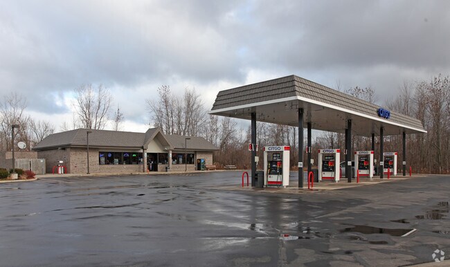
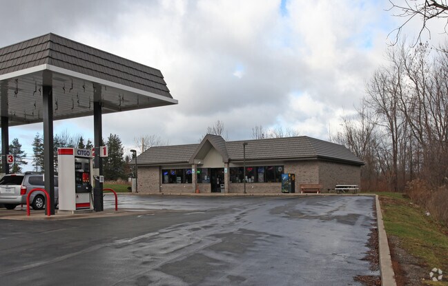
Property Record
690 Manitou Rd, Hilton, NY 14468

NEARBY LISTINGS FOR SALE OR LEASE
Property Detail
690 Manitou Rd
262800-033-010-0002-036-000
1ST DIV L47 T2
Servicestationmarket
Monroe
X
New York
36055C0061H
36.000
2025
1.40 AC
2024
Northwest
013503
Rochester
3,300 SF
Rochester, NY
DEMOGRAPHICS near 690 Manitou Rd
1 Mile
3 Mile
5 Mile
2024 Total Population
1,558
20,253
51,288
2029 Population
1,531
19,824
50,537
Pop Growth 2024-2029
(1.73%)
(2.12%)
(1.46%)
Average Age
41
43
44
2024 Total Households
560
7,880
20,495
HH Growth 2024-2029
(1.79%)
(2.25%)
(1.53%)
Median Household Inc
$111,153
$88,262
$85,499
Avg Household Size
2.70
2.50
2.40
2024 Avg HH Vehicles
2.00
2.00
2.00
Median Home Value
$255,617
$191,226
$195,400
Median Year Built
1988
1981
1982
Nearby Places
Map Layers
Map Styles
 Street
 Aerial
- Restaurants
- Banks
- Shops
- Fitness
- Groceries
PUBLIC TRANSPORTATION
AIRPORT
Frederick Douglass/Greater Rochester International
DRIVE
WALK
Distance
Frederick Douglass/Greater Rochester International
25 min
17.5 mi
Freight Ports
Albany, NY Port
DRIVE
WALK
Distance
Albany, NY Port
290 min
243.3 mi
Nearby Properties
Address
Land Use
TOTAL SIZE
Lot Size
Zoning
Address
Land Use
TOTAL SIZE
Lot Size
Zoning
69,000 SF
243.10 AC
Address
Land Use
TOTAL SIZE
Lot Size
Zoning
250,000 SF
59.11 AC
02 - SINGL
Address
Land Use
TOTAL SIZE
Lot Size
Zoning
1,763.70 AC
Address
Land Use
TOTAL SIZE
Lot Size
Zoning
236,079 SF
63.84 AC
02 - SINGL
Address
Land Use
TOTAL SIZE
Lot Size
Zoning
1.90 AC
05 - COMME
Address
Land Use
TOTAL SIZE
Lot Size
Zoning
89,396 SF
26.60 AC
02 - SINGL
Address
Land Use
TOTAL SIZE
Lot Size
Zoning
9,360 SF
23.50 AC
05 - COMME
Address
Land Use
TOTAL SIZE
Lot Size
Zoning
11,452 SF
13.10 AC
03 - MULTI
Address
Land Use
TOTAL SIZE
Lot Size
Zoning
78,957 SF
90.80 AC
02 - SINGL
Address
Land Use
TOTAL SIZE
Lot Size
Zoning
93,865 SF
62.80 AC
Address
Land Use
TOTAL SIZE
Lot Size
Zoning
6,462 SF
8.20 AC
03 - MULTI
Address
Land Use
TOTAL SIZE
Lot Size
Zoning
30,194 SF
24 AC
02 - SINGL
Address
Land Use
TOTAL SIZE
Lot Size
Zoning
31,823 SF
2.82 AC
05 - COMME
Address
Land Use
TOTAL SIZE
Lot Size
Zoning
5,758 SF
10.50 AC
Address
Land Use
TOTAL SIZE
Lot Size
Zoning
5,048 SF
11.30 AC
02 - SINGL
Address
Land Use
TOTAL SIZE
Lot Size
Zoning
64,153 SF
10.11 AC
05 - COMME
Address
Land Use
TOTAL SIZE
Lot Size
Zoning
41,280 SF
35.74 AC
Address
Land Use
TOTAL SIZE
Lot Size
Zoning
4,352 SF
20.50 AC
03 - MULTI
Address
Land Use
TOTAL SIZE
Lot Size
Zoning
17,375 SF
5.06 AC
Address
Land Use
TOTAL SIZE
Lot Size
Zoning
53,613 SF
4.20 AC
05 - COMME
Address
Land Use
TOTAL SIZE
Lot Size
Zoning
7,404 SF
84.45 AC
MR
Address
Land Use
TOTAL SIZE
Lot Size
Zoning
37.80 AC
Address
Land Use
TOTAL SIZE
Lot Size
Zoning
2,088 SF
1.97 AC
Address
Land Use
TOTAL SIZE
Lot Size
Zoning
16,212 SF
6.48 AC
02 - SINGL
Address
Land Use
TOTAL SIZE
Lot Size
Zoning
6,372 SF
2.44 AC
02 - SINGL
Address
Land Use
TOTAL SIZE
Lot Size
Zoning
37,488 SF
5.50 AC
02 - SINGL
Address
Land Use
TOTAL SIZE
Lot Size
Zoning
9,000 SF
11.96 AC
Address
Land Use
TOTAL SIZE
Lot Size
Zoning
9,288 SF
1.60 AC
03 - MULTI
Address
Land Use
TOTAL SIZE
Lot Size
Zoning
3,332 SF
2.85 AC
04 - FARM
Address
Land Use
TOTAL SIZE
Lot Size
Zoning
14,220 SF
3.20 AC
05 - COMME
The World's #1 Commercial Real Estate Marketplace
Connect with us
© 2026 CoStar Group
The information above has been obtained from sources believed reliable. While we do not doubt its accuracy we have not verified it and make no guarantee, warranty or representation about it. It is your responsibility to independently confirm its accuracy and completeness. Any projections, opinions, assumptions, or estimates used are for example only and do not represent the current or future performance of the property. The value of this transaction to you depends on tax and other factors which should be evaluated by your tax, financial, and legal advisors. You and your advisors should conduct a careful, independent investigation of the property to determine to your satisfaction the suitability of the property for your needs.