Property Record
690 Roosevelt, Irvine, CA 92620


Save to a Folder
{{folder.Name}}
{{folder.ListingIds.length}} Properties
{{folder.ListingIds.length}} Property
Create a New Folder
Property Detail
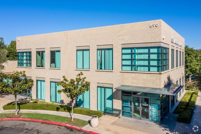
690 Roosevelt
Anaheim-Santa Ana-Irvine, CA
P BK 356 PG 30 PAR 49
529-392-50
ORANGE
Commercialnec
California
B and X Area of moderate flood hazard, usually the area between the limits of the 100-year and 500-year floods.
49
2024
0.06 AC
2025
Irvine/Tustin Legacy
052433
Orange County (California)
NEARBY LISTINGS FOR SALE OR LEASE
DEMOGRAPHICS near 690 Roosevelt
1 mile
3 mile
5 mile
2025 Total Population
26,880
184,533
378,230
2030 Population
26,380
183,788
381,319
Pop Growth 2025-2030
(1.86%)
(0.40%)
+ 0.82%
Average Age
39
39
38
2025 Total Households
9,446
65,982
135,902
HH Growth 2025-2030
(2.00%)
(0.55%)
+ 0.85%
Median Household Inc
$118,694
$133,440
$123,355
Avg Household Size
2.80
2.70
2.70
2025 Avg HH Vehicles
2.00
2.00
2.00
Median Home Value
$1,068,599
$1,076,904
$1,066,555
Median Year Built
1995
1999
1996
Nearby Places
Map Layers
Map Styles
 Street
 Aerial
Layers
 Traffic
 Biking
Places
Listings with unknown addresses are not visible on the map
- Restaurants
- Banks
- Shops
- Fitness
- Groceries
PUBLIC TRANSPORTATION
COMMUTER RAIL
Tustin Metrolink Station (Metrolink Inland Empire-Orange County Line - Metrolink Trains, Metrolink Orange County Line - Metrolink Trains)
Drive
Walk
Distance
Tustin Metrolink Station (Metrolink Inland Empire-Orange County Line - Metrolink Trains, Metrolink Orange County Line - Metrolink Trains)
8 min
3.8 mi
Irvine (Pacific Surfliner - Amtrak)
Drive
Walk
Distance
Irvine (Pacific Surfliner - Amtrak)
8 min
4.5 mi
AIRPORT
John Wayne/Orange County
Drive
Walk
Distance
John Wayne/Orange County
13 min
8.9 mi
Long Beach (Daugherty Field)
Drive
Walk
Distance
Long Beach (Daugherty Field)
36 min
28.7 mi
Ontario International
Drive
Walk
Distance
Ontario International
50 min
34.8 mi
Freight Ports
Port of Long Beach
Drive
Walk
Distance
Port of Long Beach
41 min
28.2 mi
Nearby Properties
Address
Land Use
TOTAL SIZE
Lot Size
Zoning
Address
Land Use
TOTAL SIZE
Lot Size
Zoning
42.84 AC
Address
Land Use
TOTAL SIZE
Lot Size
Zoning
Address
Land Use
TOTAL SIZE
Lot Size
Zoning
5.31 AC
Address
Land Use
TOTAL SIZE
Lot Size
Zoning
11.06 AC
Address
Land Use
TOTAL SIZE
Lot Size
Zoning
14.29 AC
Address
Land Use
TOTAL SIZE
Lot Size
Zoning
11.55 AC
Address
Land Use
TOTAL SIZE
Lot Size
Zoning
19.28 AC
Address
Land Use
TOTAL SIZE
Lot Size
Zoning
19.86 AC
Address
Land Use
TOTAL SIZE
Lot Size
Zoning
7.43 AC
Address
Land Use
TOTAL SIZE
Lot Size
Zoning
6.13 AC
Address
Land Use
TOTAL SIZE
Lot Size
Zoning
Address
Land Use
TOTAL SIZE
Lot Size
Zoning
Address
Land Use
TOTAL SIZE
Lot Size
Zoning
6.45 AC
Address
Land Use
TOTAL SIZE
Lot Size
Zoning
6.21 AC
Address
Land Use
TOTAL SIZE
Lot Size
Zoning
21.73 AC
Address
Land Use
TOTAL SIZE
Lot Size
Zoning
14.39 AC
Address
Land Use
TOTAL SIZE
Lot Size
Zoning
21.76 AC
Address
Land Use
TOTAL SIZE
Lot Size
Zoning
21.73 AC
Address
Land Use
TOTAL SIZE
Lot Size
Zoning
5.72 AC
Address
Land Use
TOTAL SIZE
Lot Size
Zoning
Address
Land Use
TOTAL SIZE
Lot Size
Zoning
14.54 AC
Address
Land Use
TOTAL SIZE
Lot Size
Zoning
14.29 AC
Address
Land Use
TOTAL SIZE
Lot Size
Zoning
15.51 AC
Address
Land Use
TOTAL SIZE
Lot Size
Zoning
5.62 AC
Address
Land Use
TOTAL SIZE
Lot Size
Zoning
14 AC
Address
Land Use
TOTAL SIZE
Lot Size
Zoning
40,633 SF
2.75 AC
Address
Land Use
TOTAL SIZE
Lot Size
Zoning
16.85 AC
Address
Land Use
TOTAL SIZE
Lot Size
Zoning
Address
Land Use
TOTAL SIZE
Lot Size
Zoning
13.97 AC
Address
Land Use
TOTAL SIZE
Lot Size
Zoning
16.13 AC
The World's #1 Commercial Real Estate Marketplace
Connect with us
© 2026 CoStar Group
The information above has been obtained from sources believed reliable. While we do not doubt its accuracy we have not verified it and make no guarantee, warranty or representation about it. It is your responsibility to independently confirm its accuracy and completeness. Any projections, opinions, assumptions, or estimates used are for example only and do not represent the current or future performance of the property. The value of this transaction to you depends on tax and other factors which should be evaluated by your tax, financial, and legal advisors. You and your advisors should conduct a careful, independent investigation of the property to determine to your satisfaction the suitability of the property for your needs.