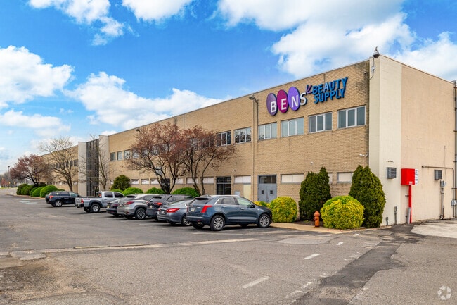
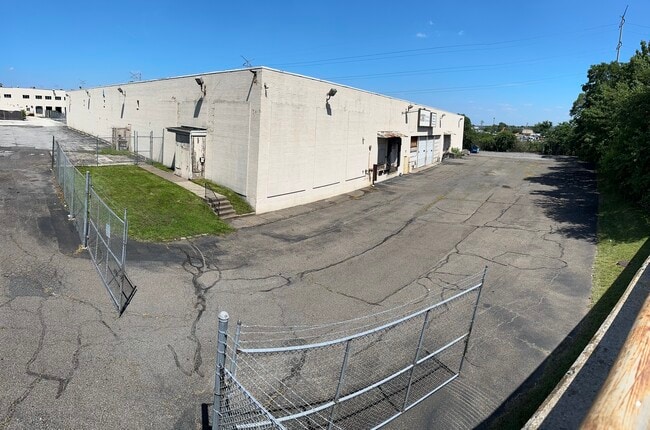
Property Record
6900 Lindbergh Blvd, Philadelphia, PA 19142

Current Lease Availabilities
NEARBY LISTINGS FOR SALE OR LEASE
Property Detail
6900 Lindbergh Blvd
Philadelphia-Camden-Wilmington, PA-NJ-DE-MD
Alta/Acsm Land Title Surv
884161700
130.179 NE OF 70TH
Industrialgeneral
Philadelphia
X
Pennsylvania
4207570186H
38
2024
7.64 AC
2026
Southwest Philly
006100
Philadelphia
241,000 SF
DEMOGRAPHICS near 6900 Lindbergh Blvd
1 Mile
3 Mile
5 Mile
2024 Total Population
23,990
204,653
699,928
2029 Population
22,976
199,295
682,446
Pop Growth 2024-2029
(4.23%)
(2.62%)
(2.50%)
Average Age
37
38
38
2024 Total Households
8,634
79,897
295,649
HH Growth 2024-2029
(4.41%)
(2.86%)
(2.77%)
Median Household Inc
$40,526
$47,601
$59,719
Avg Household Size
2.70
2.50
2.20
2024 Avg HH Vehicles
1.00
1.00
1.00
Median Home Value
$141,106
$167,300
$218,269
Median Year Built
1951
1948
1948
Nearby Places
Map Layers
Map Styles
 Street
 Aerial
- Restaurants
- Banks
- Shops
- Fitness
- Groceries
PUBLIC TRANSPORTATION
TRANSIT/SUBWAY
Elmwood Avenue And 70Th Street (Route 36 - Southeastern Pennsylvania Transportation Authority Rapid Transit (SEPTA Subway & Trolley))
DRIVE
WALK
Distance
Elmwood Avenue And 70Th Street (Route 36 - Southeastern Pennsylvania Transportation Authority Rapid Transit (SEPTA Subway & Trolley))
2 min
13 min
0.7 mi
Elmwood Avenue And 71St Street (Route 36 - Southeastern Pennsylvania Transportation Authority Rapid Transit (SEPTA Subway & Trolley))
DRIVE
WALK
Distance
Elmwood Avenue And 71St Street (Route 36 - Southeastern Pennsylvania Transportation Authority Rapid Transit (SEPTA Subway & Trolley))
2 min
14 min
0.7 mi
Elmwood Avenue And 69Th Street (Route 36 - Southeastern Pennsylvania Transportation Authority Rapid Transit (SEPTA Subway & Trolley))
DRIVE
WALK
Distance
Elmwood Avenue And 69Th Street (Route 36 - Southeastern Pennsylvania Transportation Authority Rapid Transit (SEPTA Subway & Trolley))
2 min
14 min
0.8 mi
Elmwood Avenue And 68Th Street (Route 36 - Southeastern Pennsylvania Transportation Authority Rapid Transit (SEPTA Subway & Trolley))
DRIVE
WALK
Distance
Elmwood Avenue And 68Th Street (Route 36 - Southeastern Pennsylvania Transportation Authority Rapid Transit (SEPTA Subway & Trolley))
3 min
15 min
0.8 mi
Elmwood Avenue And 67Th Street (Route 36 - Southeastern Pennsylvania Transportation Authority Rapid Transit (SEPTA Subway & Trolley))
DRIVE
WALK
Distance
Elmwood Avenue And 67Th Street (Route 36 - Southeastern Pennsylvania Transportation Authority Rapid Transit (SEPTA Subway & Trolley))
3 min
16 min
0.9 mi
COMMUTER RAIL
Eastwick (R1 - Southeastern Pennsylvania Transportation Authority Regional Rail (SEPTA Regional Rail))
DRIVE
WALK
Distance
Eastwick (R1 - Southeastern Pennsylvania Transportation Authority Regional Rail (SEPTA Regional Rail))
5 min
2.1 mi
Darby (R2 - Southeastern Pennsylvania Transportation Authority Regional Rail (SEPTA Regional Rail))
DRIVE
WALK
Distance
Darby (R2 - Southeastern Pennsylvania Transportation Authority Regional Rail (SEPTA Regional Rail))
7 min
2.1 mi
AIRPORT
Philadelphia International
DRIVE
WALK
Distance
Philadelphia International
11 min
4.4 mi
Freight Ports
South Jersey Port
DRIVE
WALK
Distance
South Jersey Port
20 min
10.6 mi
Nearby Properties
Address
Land Use
TOTAL SIZE
Lot Size
Zoning
Address
Land Use
TOTAL SIZE
Lot Size
Zoning
678,227 SF
850.40 AC
SPAIR
Address
Land Use
TOTAL SIZE
Lot Size
Zoning
28,089 SF
90.46 AC
SPPOA
Address
Land Use
TOTAL SIZE
Lot Size
Zoning
400,000 SF
3.32 AC
CMX5
Address
Land Use
TOTAL SIZE
Lot Size
Zoning
685,000 SF
47.69 AC
CMX3
Address
Land Use
TOTAL SIZE
Lot Size
Zoning
387,472 SF
4.61 AC
I3
Address
Land Use
TOTAL SIZE
Lot Size
Zoning
727,272 SF
16.70 AC
I3
Address
Land Use
TOTAL SIZE
Lot Size
Zoning
338,277 SF
114.75 AC
I3
Address
Land Use
TOTAL SIZE
Lot Size
Zoning
910,000 SF
70 AC
I2
Address
Land Use
TOTAL SIZE
Lot Size
Zoning
257.31 AC
I3
Address
Land Use
TOTAL SIZE
Lot Size
Zoning
374,706 SF
21.26 AC
CMX3
Address
Land Use
TOTAL SIZE
Lot Size
Zoning
175,069 SF
2.20 AC
CMX3
Address
Land Use
TOTAL SIZE
Lot Size
Zoning
206,365 SF
3.40 AC
RSA5
Address
Land Use
TOTAL SIZE
Lot Size
Zoning
10,080 SF
3.10 AC
I3
Address
Land Use
TOTAL SIZE
Lot Size
Zoning
488,254 SF
31.56 AC
I2
Address
Land Use
TOTAL SIZE
Lot Size
Zoning
89,456 SF
27.06 AC
Address
Land Use
TOTAL SIZE
Lot Size
Zoning
97,810 SF
40 AC
I3
Address
Land Use
TOTAL SIZE
Lot Size
Zoning
141.90 AC
I3
Address
Land Use
TOTAL SIZE
Lot Size
Zoning
124.50 AC
I3
Address
Land Use
TOTAL SIZE
Lot Size
Zoning
335,340 SF
23.83 AC
I2
Address
Land Use
TOTAL SIZE
Lot Size
Zoning
323,248 SF
2.90 AC
SPAIR
Address
Land Use
TOTAL SIZE
Lot Size
Zoning
83.63 AC
I3
Address
Land Use
TOTAL SIZE
Lot Size
Zoning
144,963 SF
1.52 AC
I2
Address
Land Use
TOTAL SIZE
Lot Size
Zoning
Address
Land Use
TOTAL SIZE
Lot Size
Zoning
95,895 SF
2.94 AC
RTA1
Address
Land Use
TOTAL SIZE
Lot Size
Zoning
180,000 SF
0.57 AC
RM4
Address
Land Use
TOTAL SIZE
Lot Size
Zoning
128,464 SF
1.03 AC
RM1
Address
Land Use
TOTAL SIZE
Lot Size
Zoning
200,000 SF
22 AC
RMX3
Address
Land Use
TOTAL SIZE
Lot Size
Zoning
164,640 SF
0.62 AC
CMX4
Address
Land Use
TOTAL SIZE
Lot Size
Zoning
226,764 SF
5.72 AC
CMX3
Address
Land Use
TOTAL SIZE
Lot Size
Zoning
140,010 SF
28.50 AC
ICMX
The World's #1 Commercial Real Estate Marketplace
Connect with us
© 2026 CoStar Group
The information above has been obtained from sources believed reliable. While we do not doubt its accuracy we have not verified it and make no guarantee, warranty or representation about it. It is your responsibility to independently confirm its accuracy and completeness. Any projections, opinions, assumptions, or estimates used are for example only and do not represent the current or future performance of the property. The value of this transaction to you depends on tax and other factors which should be evaluated by your tax, financial, and legal advisors. You and your advisors should conduct a careful, independent investigation of the property to determine to your satisfaction the suitability of the property for your needs.