Property Record
6900 Russell Rd, Durham, NC 27712
NEARBY LISTINGS FOR SALE OR LEASE
Property Detail
6900 Russell Rd
186956
PROP-COOPER JOE E & COOPE R CLARA PL:000000-000000
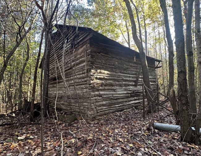
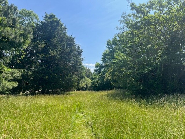
Timberlandforesttreesagricultural
Durham
AE
North Carolina
3720081500K
18.79 AC
2024
North Durham
2025
Raleigh/Durham
001604
Durham-Chapel Hill, NC
1,056 SF
DEMOGRAPHICS near 6900 Russell Rd
1 Mile
3 Mile
5 Mile
2024 Total Population
1,113
17,595
51,669
2029 Population
1,171
18,366
54,135
Pop Growth 2024-2029
+ 5.21%
+ 4.38%
+ 4.77%
Average Age
44
45
43
2024 Total Households
432
6,826
20,847
HH Growth 2024-2029
+ 5.32%
+ 4.51%
+ 4.99%
Median Household Inc
$87,096
$106,031
$89,470
Avg Household Size
2.50
2.50
2.40
2024 Avg HH Vehicles
3.00
2.00
2.00
Median Home Value
$452,298
$399,783
$395,843
Median Year Built
1987
1985
1987
Nearby Places
Map Layers
Map Styles
 Street
 Aerial
- Restaurants
- Banks
- Shops
- Fitness
- Groceries
PUBLIC TRANSPORTATION
COMMUTER RAIL
Durham Amtrak Station (Carolinian - Amtrak, Piedmont - Amtrak)
DRIVE
WALK
Distance
Durham Amtrak Station (Carolinian - Amtrak, Piedmont - Amtrak)
19 min
9.4 mi
AIRPORT
Raleigh-Durham International
DRIVE
WALK
Distance
Raleigh-Durham International
36 min
22.4 mi
Freight Ports
Virginia Port Authority - Richmond
DRIVE
WALK
Distance
Virginia Port Authority - Richmond
178 min
153.2 mi
SALE & LEASE HISTORY
LISTING DATE
SALE/LEASE

May 30, 2025
For Sale
Nearby Properties
Address
Land Use
TOTAL SIZE
Lot Size
Zoning
Address
Land Use
TOTAL SIZE
Lot Size
Zoning
297,910 SF
39.63 AC
RS-20
Address
Land Use
TOTAL SIZE
Lot Size
Zoning
256,985 SF
37.98 AC
RR
Address
Land Use
TOTAL SIZE
Lot Size
Zoning
181,738 SF
66.62 AC
RR
Address
Land Use
TOTAL SIZE
Lot Size
Zoning
80,155 SF
62.21 AC
RR,RS-20
Address
Land Use
TOTAL SIZE
Lot Size
Zoning
75,533 SF
18.97 AC
RS-20
Address
Land Use
TOTAL SIZE
Lot Size
Zoning
62,423 SF
7.47 AC
CC
Address
Land Use
TOTAL SIZE
Lot Size
Zoning
34,813 SF
14.34 AC
RS-20
Address
Land Use
TOTAL SIZE
Lot Size
Zoning
49,619 SF
13.27 AC
RS-20
Address
Land Use
TOTAL SIZE
Lot Size
Zoning
43,078 SF
24.27 AC
RR
Address
Land Use
TOTAL SIZE
Lot Size
Zoning
2,262 SF
6.59 AC
RR
Address
Land Use
TOTAL SIZE
Lot Size
Zoning
27,254 SF
3.18 AC
CC
Address
Land Use
TOTAL SIZE
Lot Size
Zoning
12,876 SF
2.58 AC
Address
Land Use
TOTAL SIZE
Lot Size
Zoning
46,449 SF
5.26 AC
RR
Address
Land Use
TOTAL SIZE
Lot Size
Zoning
24,193 SF
5.20 AC
RR
Address
Land Use
TOTAL SIZE
Lot Size
Zoning
24,618 SF
6.04 AC
AR
Address
Land Use
TOTAL SIZE
Lot Size
Zoning
18,728 SF
8.63 AC
RR
Address
Land Use
TOTAL SIZE
Lot Size
Zoning
11,552 SF
53.28 AC
RR
Address
Land Use
TOTAL SIZE
Lot Size
Zoning
12,072 SF
13.11 AC
AR
Address
Land Use
TOTAL SIZE
Lot Size
Zoning
1,532 SF
156.20 AC
RR,RS-20
Address
Land Use
TOTAL SIZE
Lot Size
Zoning
58.56 AC
AREC5
Address
Land Use
TOTAL SIZE
Lot Size
Zoning
95.14 AC
RR
Address
Land Use
TOTAL SIZE
Lot Size
Zoning
3,467 SF
112.15 AC
RR
Address
Land Use
TOTAL SIZE
Lot Size
Zoning
19.65 AC
CC
Address
Land Use
TOTAL SIZE
Lot Size
Zoning
22,026 SF
5.11 AC
RS-20
Address
Land Use
TOTAL SIZE
Lot Size
Zoning
10,000 SF
4.52 AC
RR
Address
Land Use
TOTAL SIZE
Lot Size
Zoning
4,146 SF
66.97 AC
RR
Address
Land Use
TOTAL SIZE
Lot Size
Zoning
4,466 SF
7.47 AC
The World's #1 Commercial Real Estate Marketplace
Connect with us
© 2026 CoStar Group
The information above has been obtained from sources believed reliable. While we do not doubt its accuracy we have not verified it and make no guarantee, warranty or representation about it. It is your responsibility to independently confirm its accuracy and completeness. Any projections, opinions, assumptions, or estimates used are for example only and do not represent the current or future performance of the property. The value of this transaction to you depends on tax and other factors which should be evaluated by your tax, financial, and legal advisors. You and your advisors should conduct a careful, independent investigation of the property to determine to your satisfaction the suitability of the property for your needs.