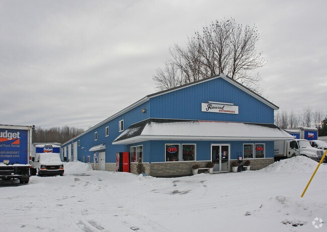
Property Record
6900 State Route 31 E, Newark, NY 14513

NEARBY LISTINGS FOR SALE OR LEASE
-
-
View all Newark listings for sale on LoopNet.com
Property Detail
6900 State Route 31 E
Rochester, NY
37111-00-423355
542089-069-111-0000-475-369-0000
Wayne
Gasolinefuelbulkstorage
New York
2025
450.356
2024
4.23 AC
021000
Wayne County
3,600 SF
Rochester
DEMOGRAPHICS near 6900 State Route 31 E
1 Mile
3 Mile
5 Mile
2024 Total Population
283
10,918
18,100
2029 Population
281
10,791
17,908
Pop Growth 2024-2029
(0.71%)
(1.16%)
(1.06%)
Average Age
47
43
43
2024 Total Households
114
4,621
7,587
HH Growth 2024-2029
(0.88%)
(1.28%)
(1.16%)
Median Household Inc
$62,368
$55,763
$57,306
Avg Household Size
2.20
2.20
2.20
2024 Avg HH Vehicles
2.00
2.00
2.00
Median Home Value
$90,195
$101,879
$106,150
Median Year Built
1969
1953
1952
Nearby Places
Map Layers
Map Styles
 Street
 Aerial
- Restaurants
- Banks
- Shops
- Fitness
- Groceries
Nearby Properties
Address
Land Use
TOTAL SIZE
Lot Size
Zoning
Address
Land Use
TOTAL SIZE
Lot Size
Zoning
89,825 SF
134.02 AC
Address
Land Use
TOTAL SIZE
Lot Size
Zoning
200,670 SF
23.13 AC
B1
Address
Land Use
TOTAL SIZE
Lot Size
Zoning
153,072 SF
33.68 AC
PID
Address
Land Use
TOTAL SIZE
Lot Size
Zoning
53,312 SF
44.89 AC
PD
Address
Land Use
TOTAL SIZE
Lot Size
Zoning
152,676 SF
27.02 AC
B3
Address
Land Use
TOTAL SIZE
Lot Size
Zoning
39,000 SF
21.49 AC
B3
Address
Land Use
TOTAL SIZE
Lot Size
Zoning
128,734 SF
16.07 AC
PD
Address
Land Use
TOTAL SIZE
Lot Size
Zoning
65,080 SF
45.77 AC
PD
Address
Land Use
TOTAL SIZE
Lot Size
Zoning
1,600 SF
31.69 AC
R2
Address
Land Use
TOTAL SIZE
Lot Size
Zoning
15,036 SF
5.26 AC
PD
Address
Land Use
TOTAL SIZE
Lot Size
Zoning
2,000 SF
52.80 AC
AG
Address
Land Use
TOTAL SIZE
Lot Size
Zoning
1,684 SF
19.70 AC
R1
Address
Land Use
TOTAL SIZE
Lot Size
Zoning
80,000 SF
8.09 AC
Address
Land Use
TOTAL SIZE
Lot Size
Zoning
5,000 SF
94.04 AC
Address
Land Use
TOTAL SIZE
Lot Size
Zoning
13,309 SF
0.94 AC
B2
Address
Land Use
TOTAL SIZE
Lot Size
Zoning
96,496 SF
7.13 AC
B3
Address
Land Use
TOTAL SIZE
Lot Size
Zoning
3.64 AC
CON
Address
Land Use
TOTAL SIZE
Lot Size
Zoning
147,918 SF
66.58 AC
PID
Address
Land Use
TOTAL SIZE
Lot Size
Zoning
1,336 SF
7.53 AC
R2
Address
Land Use
TOTAL SIZE
Lot Size
Zoning
68,330 SF
2.26 AC
B2
Address
Land Use
TOTAL SIZE
Lot Size
Zoning
91,319 SF
5.96 AC
PID
Address
Land Use
TOTAL SIZE
Lot Size
Zoning
97,037 SF
3.10 AC
PD
Address
Land Use
TOTAL SIZE
Lot Size
Zoning
41,818 SF
0.96 AC
R2
Address
Land Use
TOTAL SIZE
Lot Size
Zoning
90,645 SF
7.16 AC
PD
Address
Land Use
TOTAL SIZE
Lot Size
Zoning
64,151 SF
23.36 AC
PID
Address
Land Use
TOTAL SIZE
Lot Size
Zoning
86,156 SF
12.18 AC
B3
Address
Land Use
TOTAL SIZE
Lot Size
Zoning
1,323 SF
9.59 AC
R3
Address
Land Use
TOTAL SIZE
Lot Size
Zoning
25,352 SF
2.33 AC
B1
Address
Land Use
TOTAL SIZE
Lot Size
Zoning
11,983 SF
1.18 AC
PD
Address
Land Use
TOTAL SIZE
Lot Size
Zoning
255,882 SF
12.68 AC
PD
The World's #1 Commercial Real Estate Marketplace
Connect with us
© 2025 CoStar Group
The information above has been obtained from sources believed reliable. While we do not doubt its accuracy we have not verified it and make no guarantee, warranty or representation about it. It is your responsibility to independently confirm its accuracy and completeness. Any projections, opinions, assumptions, or estimates used are for example only and do not represent the current or future performance of the property. The value of this transaction to you depends on tax and other factors which should be evaluated by your tax, financial, and legal advisors. You and your advisors should conduct a careful, independent investigation of the property to determine to your satisfaction the suitability of the property for your needs.