Property Record
6901 Interstate 30, Little Rock, AR 72209
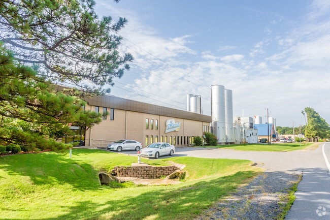

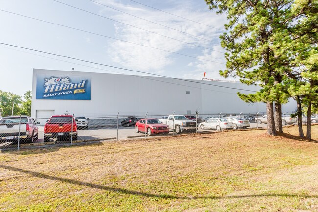
Property Detail
6901 Interstate 30
Little Rock-North Little Rock-Conway, AR
LOTS 5 & 7
34L-358-00-004-00
Pulaski
Lightindustrial
Arkansas
AE The base floodplain where base flood elevations are provided. AE Zones are now used on new format FIRMs instead of A1-A30 Zones.
5,7
2025
8.75 AC
2025
Southwest
004107
Little Rock/N Little Rock
20,163 SF
NEARBY LISTINGS FOR SALE OR LEASE
DEMOGRAPHICS near 6901 Interstate 30
1 mile
3 mile
5 mile
2025 Total Population
756
28,567
95,015
2030 Population
762
28,988
96,809
Pop Growth 2025-2030
+ 0.79%
+ 1.47%
+ 1.89%
Average Age
36
35
38
2025 Total Households
289
10,755
38,717
HH Growth 2025-2030
+ 0.69%
+ 1.54%
+ 2.03%
Median Household Inc
$63,491
$41,133
$44,308
Avg Household Size
2.50
2.50
2.30
2025 Avg HH Vehicles
2.00
2.00
2.00
Median Home Value
$145,967
$109,934
$137,336
Median Year Built
1974
1972
1969
Nearby Places
Map Layers
Map Styles
 Street
 Aerial
Layers
 Traffic
 Biking
Places
Listings with unknown addresses are not visible on the map
- Restaurants
- Banks
- Shops
- Fitness
- Groceries
PUBLIC TRANSPORTATION
COMMUTER RAIL
Drive
Walk
Distance
11 min
7.1 mi
AIRPORT
Bill and Hillary Clinton Ntl/Adams Field
Drive
Walk
Distance
Bill and Hillary Clinton Ntl/Adams Field
10 min
6.9 mi
Nearby Properties
Address
Land Use
TOTAL SIZE
Lot Size
Zoning
Address
Land Use
TOTAL SIZE
Lot Size
Zoning
10 SF
29.02 AC
Address
Land Use
TOTAL SIZE
Lot Size
Zoning
79,751 SF
28.57 AC
Address
Land Use
TOTAL SIZE
Lot Size
Zoning
239,345 SF
19.70 AC
Address
Land Use
TOTAL SIZE
Lot Size
Zoning
34,925 SF
12.59 AC
Address
Land Use
TOTAL SIZE
Lot Size
Zoning
83,466 SF
5.46 AC
Address
Land Use
TOTAL SIZE
Lot Size
Zoning
41,652 SF
10.86 AC
Address
Land Use
TOTAL SIZE
Lot Size
Zoning
50,433 SF
22.23 AC
Address
Land Use
TOTAL SIZE
Lot Size
Zoning
24,492 SF
8.92 AC
Address
Land Use
TOTAL SIZE
Lot Size
Zoning
131,278 SF
6.37 AC
Address
Land Use
TOTAL SIZE
Lot Size
Zoning
139,410 SF
8.35 AC
Address
Land Use
TOTAL SIZE
Lot Size
Zoning
24,520 SF
10.92 AC
Address
Land Use
TOTAL SIZE
Lot Size
Zoning
6,161 SF
40.08 AC
Address
Land Use
TOTAL SIZE
Lot Size
Zoning
152,350 SF
13.57 AC
Address
Land Use
TOTAL SIZE
Lot Size
Zoning
75,900 SF
20.18 AC
Address
Land Use
TOTAL SIZE
Lot Size
Zoning
35,069 SF
43.11 AC
Address
Land Use
TOTAL SIZE
Lot Size
Zoning
64,182 SF
17.80 AC
Address
Land Use
TOTAL SIZE
Lot Size
Zoning
59,076 SF
22.27 AC
Address
Land Use
TOTAL SIZE
Lot Size
Zoning
345,000 SF
13.21 AC
Address
Land Use
TOTAL SIZE
Lot Size
Zoning
33,216 SF
12.59 AC
Address
Land Use
TOTAL SIZE
Lot Size
Zoning
85,458 SF
9.86 AC
Address
Land Use
TOTAL SIZE
Lot Size
Zoning
10,629 SF
12 AC
Address
Land Use
TOTAL SIZE
Lot Size
Zoning
81,021 SF
10.28 AC
Address
Land Use
TOTAL SIZE
Lot Size
Zoning
62,326 SF
5.84 AC
Address
Land Use
TOTAL SIZE
Lot Size
Zoning
573,416 SF
57.83 AC
Address
Land Use
TOTAL SIZE
Lot Size
Zoning
2,881 SF
14.04 AC
Address
Land Use
TOTAL SIZE
Lot Size
Zoning
58,156 SF
4.35 AC
Address
Land Use
TOTAL SIZE
Lot Size
Zoning
1,233 SF
6.19 AC
Address
Land Use
TOTAL SIZE
Lot Size
Zoning
38,640 SF
11.48 AC
Address
Land Use
TOTAL SIZE
Lot Size
Zoning
27,760 SF
9.95 AC
Address
Land Use
TOTAL SIZE
Lot Size
Zoning
4,000 SF
23.11 AC
The World's #1 Commercial Real Estate Marketplace
Connect with us
© 2026 CoStar Group
The information above has been obtained from sources believed reliable. While we do not doubt its accuracy we have not verified it and make no guarantee, warranty or representation about it. It is your responsibility to independently confirm its accuracy and completeness. Any projections, opinions, assumptions, or estimates used are for example only and do not represent the current or future performance of the property. The value of this transaction to you depends on tax and other factors which should be evaluated by your tax, financial, and legal advisors. You and your advisors should conduct a careful, independent investigation of the property to determine to your satisfaction the suitability of the property for your needs.