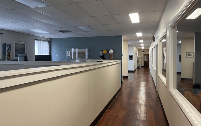
Property Record
6901 Kingsessing Ave, Philadelphia, PA 19142
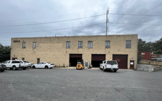
This Property Is For Sale
NEARBY LISTINGS FOR SALE OR LEASE
Property Detail
6901 Kingsessing Ave
Philadelphia-Camden-Wilmington, PA-NJ-DE-MD
Nut House At 817-819 2Nd Street Condomin
884348305
77.639 SE ANG PT NES 70
Warehouse
Philadelphia
X
Pennsylvania
4207570186H
99
2024
0.66 AC
2026
Southwest Philly
006400
Philadelphia
9,440 SF
DEMOGRAPHICS near 6901 Kingsessing Ave
1 Mile
3 Mile
5 Mile
2024 Total Population
44,338
279,330
751,398
2029 Population
44,077
279,318
750,811
Pop Growth 2024-2029
(0.59%)
0.00%
(0.08%)
Average Age
37
38
38
2024 Total Households
15,970
108,376
312,182
HH Growth 2024-2029
(0.56%)
(0.08%)
(0.25%)
Median Household Inc
$46,537
$51,148
$66,638
Avg Household Size
2.70
2.50
2.30
2024 Avg HH Vehicles
1.00
1.00
1.00
Median Home Value
$142,118
$173,010
$259,904
Median Year Built
1949
1948
1948
Nearby Places
Map Layers
Map Styles
 Street
 Aerial
- Restaurants
- Banks
- Shops
- Fitness
- Groceries
PUBLIC TRANSPORTATION
TRANSIT/SUBWAY
Woodland Avenue And 68Th Street (Route 11 - Southeastern Pennsylvania Transportation Authority Rapid Transit (SEPTA Subway & Trolley))
DRIVE
WALK
Distance
Woodland Avenue And 68Th Street (Route 11 - Southeastern Pennsylvania Transportation Authority Rapid Transit (SEPTA Subway & Trolley))
1 min
5 min
0.3 mi
Woodland Avenue And 70Th Street (Route 11 - Southeastern Pennsylvania Transportation Authority Rapid Transit (SEPTA Subway & Trolley))
DRIVE
WALK
Distance
Woodland Avenue And 70Th Street (Route 11 - Southeastern Pennsylvania Transportation Authority Rapid Transit (SEPTA Subway & Trolley))
0 min
5 min
0.3 mi
Woodland Avenue And 69Th Street (Route 11 - Southeastern Pennsylvania Transportation Authority Rapid Transit (SEPTA Subway & Trolley))
DRIVE
WALK
Distance
Woodland Avenue And 69Th Street (Route 11 - Southeastern Pennsylvania Transportation Authority Rapid Transit (SEPTA Subway & Trolley))
1 min
5 min
0.3 mi
Chester Avenue And Church Lane (Route 13 - Southeastern Pennsylvania Transportation Authority Rapid Transit (SEPTA Subway & Trolley))
DRIVE
WALK
Distance
Chester Avenue And Church Lane (Route 13 - Southeastern Pennsylvania Transportation Authority Rapid Transit (SEPTA Subway & Trolley))
2 min
6 min
0.4 mi
Woodland Avenue And 71St Street (Route 11 - Southeastern Pennsylvania Transportation Authority Rapid Transit (SEPTA Subway & Trolley))
DRIVE
WALK
Distance
Woodland Avenue And 71St Street (Route 11 - Southeastern Pennsylvania Transportation Authority Rapid Transit (SEPTA Subway & Trolley))
1 min
6 min
0.4 mi
COMMUTER RAIL
Darby (R2 - Southeastern Pennsylvania Transportation Authority Regional Rail (SEPTA Regional Rail))
DRIVE
WALK
Distance
Darby (R2 - Southeastern Pennsylvania Transportation Authority Regional Rail (SEPTA Regional Rail))
4 min
1.4 mi
Fernwood-Yeadon (R3 - Southeastern Pennsylvania Transportation Authority Regional Rail (SEPTA Regional Rail))
DRIVE
WALK
Distance
Fernwood-Yeadon (R3 - Southeastern Pennsylvania Transportation Authority Regional Rail (SEPTA Regional Rail))
5 min
1.7 mi
AIRPORT
Philadelphia International
DRIVE
WALK
Distance
Philadelphia International
12 min
5.2 mi
Freight Ports
South Jersey Port
DRIVE
WALK
Distance
South Jersey Port
23 min
10.2 mi
Nearby Properties
Address
Land Use
TOTAL SIZE
Lot Size
Zoning
Address
Land Use
TOTAL SIZE
Lot Size
Zoning
678,227 SF
850.40 AC
SPAIR
Address
Land Use
TOTAL SIZE
Lot Size
Zoning
696,920 SF
10.55 AC
SPINS
Address
Land Use
TOTAL SIZE
Lot Size
Zoning
385,000 SF
2.49 AC
SPINS
Address
Land Use
TOTAL SIZE
Lot Size
Zoning
375,500 SF
1.40 AC
CMX5
Address
Land Use
TOTAL SIZE
Lot Size
Zoning
400,000 SF
3.32 AC
CMX5
Address
Land Use
TOTAL SIZE
Lot Size
Zoning
685,000 SF
47.69 AC
CMX3
Address
Land Use
TOTAL SIZE
Lot Size
Zoning
387,472 SF
4.61 AC
I3
Address
Land Use
TOTAL SIZE
Lot Size
Zoning
303,750 SF
1.36 AC
SPINS
Address
Land Use
TOTAL SIZE
Lot Size
Zoning
269,171 SF
2.64 AC
SPINS
Address
Land Use
TOTAL SIZE
Lot Size
Zoning
910,000 SF
70 AC
I2
Address
Land Use
TOTAL SIZE
Lot Size
Zoning
413,808 SF
0.76 AC
RM4
Address
Land Use
TOTAL SIZE
Lot Size
Zoning
374,706 SF
21.26 AC
CMX3
Address
Land Use
TOTAL SIZE
Lot Size
Zoning
175,069 SF
2.20 AC
CMX3
Address
Land Use
TOTAL SIZE
Lot Size
Zoning
206,365 SF
3.40 AC
RSA5
Address
Land Use
TOTAL SIZE
Lot Size
Zoning
10,080 SF
3.10 AC
I3
Address
Land Use
TOTAL SIZE
Lot Size
Zoning
76,614 SF
1.53 AC
CMX3
Address
Land Use
TOTAL SIZE
Lot Size
Zoning
488,254 SF
31.56 AC
I2
Address
Land Use
TOTAL SIZE
Lot Size
Zoning
97,810 SF
40 AC
I3
Address
Land Use
TOTAL SIZE
Lot Size
Zoning
154,555 SF
1.42 AC
SPINS
Address
Land Use
TOTAL SIZE
Lot Size
Zoning
232,225 SF
0.86 AC
CMX4
Address
Land Use
TOTAL SIZE
Lot Size
Zoning
461,834 SF
4.73 AC
CMX3
Address
Land Use
TOTAL SIZE
Lot Size
Zoning
374,105 SF
5.63 AC
CMX3
Address
Land Use
TOTAL SIZE
Lot Size
Zoning
323,248 SF
2.90 AC
SPAIR
Address
Land Use
TOTAL SIZE
Lot Size
Zoning
144,963 SF
1.52 AC
I2
Address
Land Use
TOTAL SIZE
Lot Size
Zoning
190,150 SF
0.77 AC
RM1
Address
Land Use
TOTAL SIZE
Lot Size
Zoning
1.65 AC
CMX3
Address
Land Use
TOTAL SIZE
Lot Size
Zoning
178,878 SF
0.23 AC
CMX4
Address
Land Use
TOTAL SIZE
Lot Size
Zoning
95,895 SF
2.94 AC
RTA1
Address
Land Use
TOTAL SIZE
Lot Size
Zoning
180,000 SF
0.57 AC
RM4
Address
Land Use
TOTAL SIZE
Lot Size
Zoning
7.96 AC
The World's #1 Commercial Real Estate Marketplace
Connect with us
© 2025 CoStar Group
The information above has been obtained from sources believed reliable. While we do not doubt its accuracy we have not verified it and make no guarantee, warranty or representation about it. It is your responsibility to independently confirm its accuracy and completeness. Any projections, opinions, assumptions, or estimates used are for example only and do not represent the current or future performance of the property. The value of this transaction to you depends on tax and other factors which should be evaluated by your tax, financial, and legal advisors. You and your advisors should conduct a careful, independent investigation of the property to determine to your satisfaction the suitability of the property for your needs.