Property Record
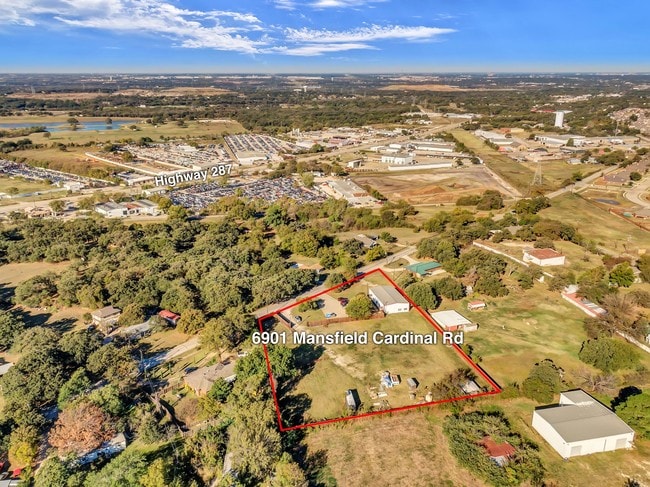
6901 Mansfield Cardinal Rd, Kennedale, TX 76060

Save to a Folder
{{folder.Name}}
{{folder.ListingIds.length}} Properties
{{folder.ListingIds.length}} Property
Create a New Folder
Property Detail
6901 Mansfield Cardinal Rd
Dallas-Fort Worth-Arlington, TX
RUSSELL, JESSE LOT 4 PER PLAT B 1247
06824951
Tarrant
Commercialnec
Texas
B and X Area of moderate flood hazard, usually the area between the limits of the 100-year and 500-year floods.
4
2025
1.99 AC
2025
Arlington
111411
Dallas/Ft Worth
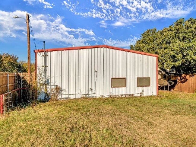
2,800 SF
NEARBY LISTINGS FOR SALE OR LEASE
DEMOGRAPHICS near 6901 Mansfield Cardinal Rd
1 mile
3 mile
5 mile
2025 Total Population
3,644
53,006
180,713
2030 Population
3,897
55,818
189,858
Pop Growth 2025-2030
+ 6.94%
+ 5.31%
+ 5.06%
Average Age
39
40
39
2025 Total Households
1,276
19,620
63,117
HH Growth 2025-2030
+ 6.97%
+ 5.40%
+ 5.21%
Median Household Inc
$126,821
$99,578
$91,961
Avg Household Size
2.80
2.70
2.80
2025 Avg HH Vehicles
2.00
2.00
2.00
Median Home Value
$486,894
$363,668
$341,816
Median Year Built
2005
1990
1989
Nearby Places
Map Layers
Map Styles
 Street
 Aerial
Layers
 Traffic
 Biking
Places
Listings with unknown addresses are not visible on the map
- Restaurants
- Banks
- Shops
- Fitness
- Groceries
PUBLIC TRANSPORTATION
AIRPORT
Dallas-Fort Worth International
Drive
Walk
Distance
Dallas-Fort Worth International
42 min
28.5 mi
Dallas Love Field
Drive
Walk
Distance
Dallas Love Field
51 min
37.2 mi
SALE & LEASE HISTORY
LISTING DATE
SALE/LEASE

Nov 15, 2019
For Sale
Nearby Properties
Address
Land Use
TOTAL SIZE
Lot Size
Zoning
Address
Land Use
TOTAL SIZE
Lot Size
Zoning
256,088 SF
10.27 AC
Address
Land Use
TOTAL SIZE
Lot Size
Zoning
170,082 SF
36.49 AC
Address
Land Use
TOTAL SIZE
Lot Size
Zoning
214,444 SF
17.45 AC
Address
Land Use
TOTAL SIZE
Lot Size
Zoning
167,643 SF
8.99 AC
Address
Land Use
TOTAL SIZE
Lot Size
Zoning
186,894 SF
10.85 AC
Address
Land Use
TOTAL SIZE
Lot Size
Zoning
169,347 SF
13.92 AC
Address
Land Use
TOTAL SIZE
Lot Size
Zoning
222,500 SF
13.86 AC
Address
Land Use
TOTAL SIZE
Lot Size
Zoning
169,837 SF
9.44 AC
Address
Land Use
TOTAL SIZE
Lot Size
Zoning
180,556 SF
11.78 AC
Address
Land Use
TOTAL SIZE
Lot Size
Zoning
147,822 SF
9.45 AC
Address
Land Use
TOTAL SIZE
Lot Size
Zoning
193,290 SF
10.56 AC
Address
Land Use
TOTAL SIZE
Lot Size
Zoning
217,786 SF
39.04 AC
Address
Land Use
TOTAL SIZE
Lot Size
Zoning
159,030 SF
10.32 AC
Address
Land Use
TOTAL SIZE
Lot Size
Zoning
268,603 SF
12.45 AC
Address
Land Use
TOTAL SIZE
Lot Size
Zoning
238,119 SF
7.52 AC
Address
Land Use
TOTAL SIZE
Lot Size
Zoning
142,110 SF
7.40 AC
Address
Land Use
TOTAL SIZE
Lot Size
Zoning
119,741 SF
45 AC
Address
Land Use
TOTAL SIZE
Lot Size
Zoning
81,540 SF
11.89 AC
Address
Land Use
TOTAL SIZE
Lot Size
Zoning
80,907 SF
29 AC
Address
Land Use
TOTAL SIZE
Lot Size
Zoning
44,669 SF
9.05 AC
Address
Land Use
TOTAL SIZE
Lot Size
Zoning
77,884 SF
30.70 AC
Address
Land Use
TOTAL SIZE
Lot Size
Zoning
127,690 SF
37.21 AC
Address
Land Use
TOTAL SIZE
Lot Size
Zoning
41,960 SF
13.70 AC
Address
Land Use
TOTAL SIZE
Lot Size
Zoning
143,104 SF
7.75 AC
Address
Land Use
TOTAL SIZE
Lot Size
Zoning
64,903 SF
2.64 AC
Address
Land Use
TOTAL SIZE
Lot Size
Zoning
210,939 SF
18.35 AC
Address
Land Use
TOTAL SIZE
Lot Size
Zoning
110,621 SF
12.27 AC
Address
Land Use
TOTAL SIZE
Lot Size
Zoning
108,708 SF
16.64 AC
Address
Land Use
TOTAL SIZE
Lot Size
Zoning
50,669 SF
7.25 AC
Address
Land Use
TOTAL SIZE
Lot Size
Zoning
112,110 SF
14.64 AC
The World's #1 Commercial Real Estate Marketplace
Connect with us
© 2026 CoStar Group
The information above has been obtained from sources believed reliable. While we do not doubt its accuracy we have not verified it and make no guarantee, warranty or representation about it. It is your responsibility to independently confirm its accuracy and completeness. Any projections, opinions, assumptions, or estimates used are for example only and do not represent the current or future performance of the property. The value of this transaction to you depends on tax and other factors which should be evaluated by your tax, financial, and legal advisors. You and your advisors should conduct a careful, independent investigation of the property to determine to your satisfaction the suitability of the property for your needs.