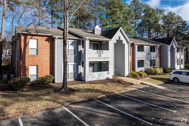
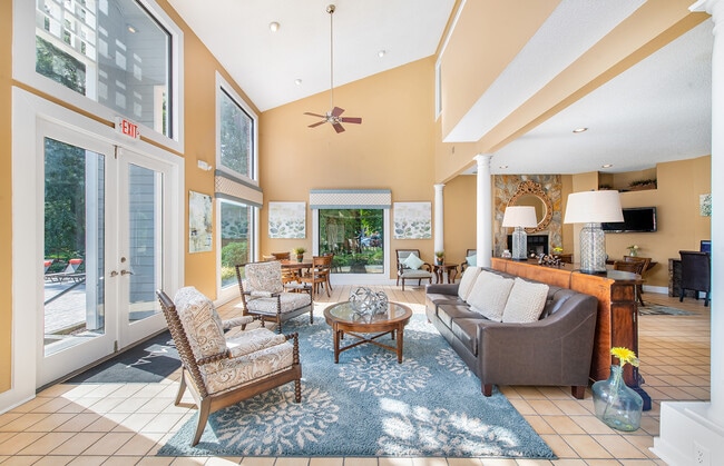
Property Record
6901 Marlowe Rd, Richmond, VA 23225

Property Detail
6901 Marlowe Rd
C005-0603-014
PARCEL A 0307.76X0739.98 IRG0027.300 AC
Apartmenthouse100plusunits
Richmond City
R-3 SINGLE
Virginia
AE The base floodplain where base flood elevations are provided. AE Zones are now used on new format FIRMs instead of A1-A30 Zones.
27.32 AC
2025
Jahnke
2026
Richmond VA
071003
Richmond, VA
194,463 SF
NEARBY LISTINGS FOR SALE OR LEASE
DEMOGRAPHICS near 6901 Marlowe Rd
1 mile
3 mile
5 mile
2025 Total Population
11,603
71,987
236,759
2030 Population
12,097
74,399
245,372
Pop Growth 2025-2030
+ 4.26%
+ 3.35%
+ 3.64%
Average Age
39
40
39
2025 Total Households
5,558
30,692
102,009
HH Growth 2025-2030
+ 4.25%
+ 3.36%
+ 3.76%
Median Household Inc
$50,979
$71,557
$76,855
Avg Household Size
2.00
2.30
2.20
2025 Avg HH Vehicles
1.00
2.00
2.00
Median Home Value
$259,865
$331,199
$358,710
Median Year Built
1983
1973
1970
Nearby Places
Map Layers
Map Styles
 Street
 Aerial
Layers
 Traffic
 Biking
Places
Listings with unknown addresses are not visible on the map
- Restaurants
- Banks
- Shops
- Fitness
- Groceries
PUBLIC TRANSPORTATION
COMMUTER RAIL
Richmond Main Street Amtrak Station (Northeast Regional - Amtrak)
Drive
Walk
Distance
Richmond Main Street Amtrak Station (Northeast Regional - Amtrak)
13 min
7.5 mi
Richmond Staples Mill Road Amtrak Station (Carolinian - Amtrak, Northeast Regional - Amtrak, Palmetto - Amtrak, Silver Meteor - Amtrak)
Drive
Walk
Distance
Richmond Staples Mill Road Amtrak Station (Carolinian - Amtrak, Northeast Regional - Amtrak, Palmetto - Amtrak, Silver Meteor - Amtrak)
16 min
9.5 mi
AIRPORT
Richmond International
Drive
Walk
Distance
Richmond International
28 min
17.4 mi
Freight Ports
Virginia Port Authority - Richmond
Drive
Walk
Distance
Virginia Port Authority - Richmond
19 min
8.8 mi
Nearby Properties
Address
Land Use
TOTAL SIZE
Lot Size
Zoning
Address
Land Use
TOTAL SIZE
Lot Size
Zoning
281,961 SF
32.19 AC
R-73 MULTI
Address
Land Use
TOTAL SIZE
Lot Size
Zoning
98,112 SF
71.88 AC
MULTIPLE Z
Address
Land Use
TOTAL SIZE
Lot Size
Zoning
46,620 SF
12.78 AC
C4 - REGIO
Address
Land Use
TOTAL SIZE
Lot Size
Zoning
196,592 SF
30.85 AC
R-48 MULTI
Address
Land Use
TOTAL SIZE
Lot Size
Zoning
182,896 SF
42.37 AC
R-43 MULTI
Address
Land Use
TOTAL SIZE
Lot Size
Zoning
280,360 SF
4.03 AC
C4 - REGIO
Address
Land Use
TOTAL SIZE
Lot Size
Zoning
13,781 SF
24.53 AC
RMF - RES,
Address
Land Use
TOTAL SIZE
Lot Size
Zoning
292,968 SF
24.03 AC
MULTIPLE Z
Address
Land Use
TOTAL SIZE
Lot Size
Zoning
48,159 SF
14.64 AC
RMF - RES,
Address
Land Use
TOTAL SIZE
Lot Size
Zoning
261,000 SF
10.36 AC
RMF - RES,
Address
Land Use
TOTAL SIZE
Lot Size
Zoning
220,462 SF
9.43 AC
C3 - COMMU
Address
Land Use
TOTAL SIZE
Lot Size
Zoning
155,353 SF
26.01 AC
R-2 SINGLE
Address
Land Use
TOTAL SIZE
Lot Size
Zoning
313,767 SF
32.12 AC
R7 - SINGL
Address
Land Use
TOTAL SIZE
Lot Size
Zoning
235,098 SF
37.52 AC
R-2 SINGLE
Address
Land Use
TOTAL SIZE
Lot Size
Zoning
224,780 SF
12.27 AC
B-3 GENERA
Address
Land Use
TOTAL SIZE
Lot Size
Zoning
342,348 SF
2.87 AC
C4 - REGIO
Address
Land Use
TOTAL SIZE
Lot Size
Zoning
232,971 SF
27.17 AC
R7 - SINGL
Address
Land Use
TOTAL SIZE
Lot Size
Zoning
110,320 SF
13.07 AC
R-43 MULTI
Address
Land Use
TOTAL SIZE
Lot Size
Zoning
3,713 SF
24.57 AC
R-43 MULTI
Address
Land Use
TOTAL SIZE
Lot Size
Zoning
327,756 SF
11.10 AC
R-53 MULTI
Address
Land Use
TOTAL SIZE
Lot Size
Zoning
79,492 SF
23.72 AC
A - AGRICU
Address
Land Use
TOTAL SIZE
Lot Size
Zoning
20,078 SF
100 AC
A - AGRICU
Address
Land Use
TOTAL SIZE
Lot Size
Zoning
183,759 SF
19.59 AC
R-3 SINGLE
Address
Land Use
TOTAL SIZE
Lot Size
Zoning
213,228 SF
9.57 AC
R-53 MULTI
Address
Land Use
TOTAL SIZE
Lot Size
Zoning
233,301 SF
11.69 AC
R-53 MULTI
Address
Land Use
TOTAL SIZE
Lot Size
Zoning
224,780 SF
12.27 AC
B-3 GENERA
Address
Land Use
TOTAL SIZE
Lot Size
Zoning
200 SF
23.61 AC
R7 - SINGL
Address
Land Use
TOTAL SIZE
Lot Size
Zoning
142,352 SF
14.34 AC
R-43 MULTI
Address
Land Use
TOTAL SIZE
Lot Size
Zoning
166,968 SF
6 AC
R-2 SINGLE
The World's #1 Commercial Real Estate Marketplace
Connect with us
© 2026 CoStar Group
The information above has been obtained from sources believed reliable. While we do not doubt its accuracy we have not verified it and make no guarantee, warranty or representation about it. It is your responsibility to independently confirm its accuracy and completeness. Any projections, opinions, assumptions, or estimates used are for example only and do not represent the current or future performance of the property. The value of this transaction to you depends on tax and other factors which should be evaluated by your tax, financial, and legal advisors. You and your advisors should conduct a careful, independent investigation of the property to determine to your satisfaction the suitability of the property for your needs.