Property Record
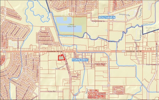
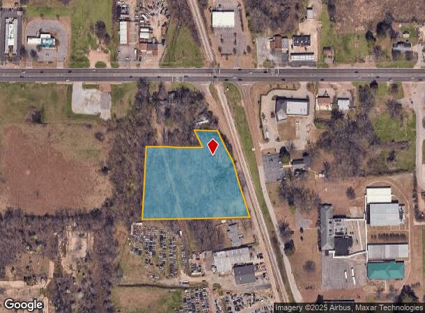
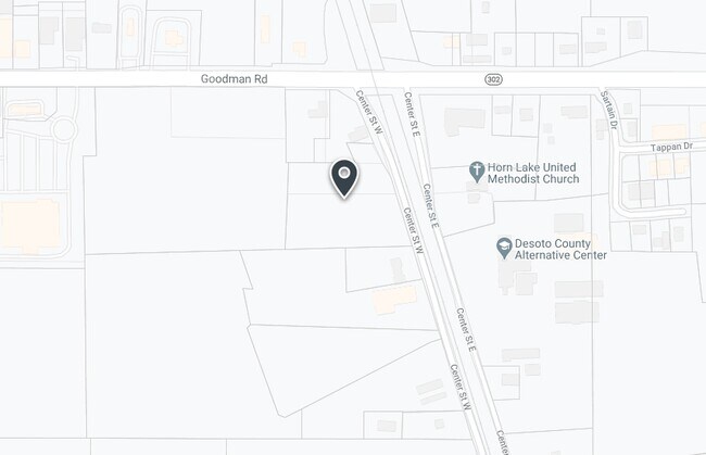
6901 Wallace Ln, Horn Lake, MS 38637
NEARBY LISTINGS FOR SALE OR LEASE
Property Detail
6901 Wallace Ln
Memphis, TN-MS-AR
DeSoto
1088340000001800
Mississippi
Singlefamilyresidentialassumed
3.50 AC
X
DeSoto County
47157C0560F
Memphis
1,722 SF
DEMOGRAPHICS near 6901 Wallace Ln
1 Mile
3 Mile
5 Mile
2024 Total Population
6,538
52,105
110,023
2029 Population
7,126
56,787
116,721
Pop Growth 2024-2029
+ 8.99%
+ 8.99%
+ 6.09%
Average Age
37
37
38
2024 Total Households
2,411
20,175
41,719
HH Growth 2024-2029
+ 9.04%
+ 9.19%
+ 6.14%
Median Household Inc
$46,379
$46,565
$49,901
Avg Household Size
2.60
2.50
2.60
2024 Avg HH Vehicles
2.00
2.00
2.00
Median Home Value
$95,959
$140,490
$148,802
Median Year Built
1979
1990
1984
Nearby Places
- Restaurants
- Banks
- Shops
- Fitness
- Groceries
PUBLIC TRANSPORTATION
AIRPORT
Memphis International
DRIVE
WALK
Distance
Memphis International
15 min
9.9 mi
Freight Ports
Port of Shreveport
DRIVE
WALK
Distance
Port of Shreveport
416 min
383.6 mi
SALE & LEASE HISTORY
LISTING DATE
SALE/LEASE

Mar 20, 2019
For Sale
Jun 13, 2018
For Sale
Jun 06, 2018
For Sale
Jul 16, 2019
For Sale
Nearby Properties
Address
Land Use
TOTAL SIZE
Lot Size
Zoning
Address
Land Use
TOTAL SIZE
Lot Size
Zoning
1,009,363 SF
78.56 AC
EMP
Address
Land Use
TOTAL SIZE
Lot Size
Zoning
1,040,736 SF
57.67 AC
M-1
Address
Land Use
TOTAL SIZE
Lot Size
Zoning
868,060 SF
51.02 AC
PBP
Address
Land Use
TOTAL SIZE
Lot Size
Zoning
811,203 SF
47.71 AC
M-1
Address
Land Use
TOTAL SIZE
Lot Size
Zoning
230,103 SF
22.07 AC
CMU-2
Address
Land Use
TOTAL SIZE
Lot Size
Zoning
23,183 SF
33.02 AC
PUD
Address
Land Use
TOTAL SIZE
Lot Size
Zoning
843,202 SF
51 AC
PBP
Address
Land Use
TOTAL SIZE
Lot Size
Zoning
39.98 AC
PUD
Address
Land Use
TOTAL SIZE
Lot Size
Zoning
62,561 SF
33.01 AC
PUD
Address
Land Use
TOTAL SIZE
Lot Size
Zoning
18,830 SF
25.45 AC
PUD
Address
Land Use
TOTAL SIZE
Lot Size
Zoning
15,472 SF
25.97 AC
PUD
Address
Land Use
TOTAL SIZE
Lot Size
Zoning
611,307 SF
29.51 AC
PBP
Address
Land Use
TOTAL SIZE
Lot Size
Zoning
618,927 SF
28.71 AC
PBP
Address
Land Use
TOTAL SIZE
Lot Size
Zoning
14,122 SF
24 AC
PUD
Address
Land Use
TOTAL SIZE
Lot Size
Zoning
554,932 SF
24.57 AC
PBP
Address
Land Use
TOTAL SIZE
Lot Size
Zoning
408,580 SF
31.28 AC
M-1
Address
Land Use
TOTAL SIZE
Lot Size
Zoning
397,766 SF
37.80 AC
PBP
Address
Land Use
TOTAL SIZE
Lot Size
Zoning
468,106 SF
22.28 AC
PBP
Address
Land Use
TOTAL SIZE
Lot Size
Zoning
11,937 SF
18.14 AC
PUD
Address
Land Use
TOTAL SIZE
Lot Size
Zoning
59,264 SF
7.28 AC
RU-3
Address
Land Use
TOTAL SIZE
Lot Size
Zoning
34,358 SF
26.89 AC
C-4
Address
Land Use
TOTAL SIZE
Lot Size
Zoning
10,341 SF
13.94 AC
RM-6
Address
Land Use
TOTAL SIZE
Lot Size
Zoning
430,984 SF
21.84 AC
PBP
Address
Land Use
TOTAL SIZE
Lot Size
Zoning
12,775 SF
26.29 AC
PUD
Address
Land Use
TOTAL SIZE
Lot Size
Zoning
Address
Land Use
TOTAL SIZE
Lot Size
Zoning
330,598 SF
24.49 AC
PBP
Address
Land Use
TOTAL SIZE
Lot Size
Zoning
349,667 SF
15.98 AC
PBP
Address
Land Use
TOTAL SIZE
Lot Size
Zoning
70,434 SF
25 AC
C-4
Address
Land Use
TOTAL SIZE
Lot Size
Zoning
20,588 SF
14 AC
PUD
Address
Land Use
TOTAL SIZE
Lot Size
Zoning
192,408 SF
29 AC
C-4
The World's #1 Commercial Real Estate Marketplace
Connect with us
© 2025 CoStar Group
The information above has been obtained from sources believed reliable. While we do not doubt its accuracy we have not verified it and make no guarantee, warranty or representation about it. It is your responsibility to independently confirm its accuracy and completeness. Any projections, opinions, assumptions, or estimates used are for example only and do not represent the current or future performance of the property. The value of this transaction to you depends on tax and other factors which should be evaluated by your tax, financial, and legal advisors. You and your advisors should conduct a careful, independent investigation of the property to determine to your satisfaction the suitability of the property for your needs.