Property Record
6905 E Orem Dr, Houston, TX 77075

Property Detail
6905 E Orem Dr
1307400010001
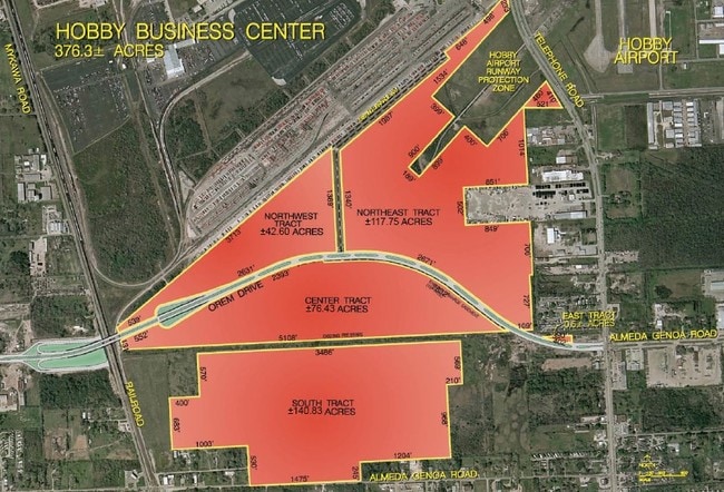
RES A BLK 1 HOBBY BUSINESS CENTER INDUSTRIAL PARK SEC 1
Truckterminal
HARRIS
B and X Area of moderate flood hazard, usually the area between the limits of the 100-year and 500-year floods.
Texas
2024
47.16 AC
2025
South
333700
Houston
71,340 SF
Houston-Pasadena-The Woodlands, TX
NEARBY LISTINGS FOR SALE OR LEASE
DEMOGRAPHICS near 6905 E Orem Dr
1 mile
3 mile
5 mile
2025 Total Population
2,508
70,570
294,384
2030 Population
2,791
75,997
315,873
Pop Growth 2025-2030
+ 11.28%
+ 7.69%
+ 7.30%
Average Age
34
36
36
2025 Total Households
754
23,242
98,371
HH Growth 2025-2030
+ 11.54%
+ 8.02%
+ 7.60%
Median Household Inc
$64,390
$60,508
$58,717
Avg Household Size
3.30
3.00
2.90
2025 Avg HH Vehicles
2.00
2.00
2.00
Median Home Value
$241,785
$234,548
$221,888
Median Year Built
1998
1978
1976
Nearby Places
Map Layers
Map Styles
 Street
 Aerial
Transit
 Traffic
 Biking
Places
Listings with unknown addresses are not visible on the map
- Restaurants
- Banks
- Shops
- Fitness
- Groceries
PUBLIC TRANSPORTATION
AIRPORT
William P Hobby
Drive
Walk
Distance
William P Hobby
10 min
2.9 mi
George Bush Intcntl/Houston
Drive
Walk
Distance
George Bush Intcntl/Houston
46 min
33.6 mi
Freight Ports
Port of Houston
Drive
Walk
Distance
Port of Houston
22 min
11.0 mi
Nearby Properties
Address
Land Use
TOTAL SIZE
Lot Size
Zoning
Address
Land Use
TOTAL SIZE
Lot Size
Zoning
1,226,700 SF
92.85 AC
Address
Land Use
TOTAL SIZE
Lot Size
Zoning
603,780 SF
36.94 AC
Address
Land Use
TOTAL SIZE
Lot Size
Zoning
589,830 SF
47.20 AC
Address
Land Use
TOTAL SIZE
Lot Size
Zoning
359,985 SF
12.56 AC
Address
Land Use
TOTAL SIZE
Lot Size
Zoning
309,102 SF
16.81 AC
Address
Land Use
TOTAL SIZE
Lot Size
Zoning
316,800 SF
16.03 AC
Address
Land Use
TOTAL SIZE
Lot Size
Zoning
556,568 SF
20 AC
Address
Land Use
TOTAL SIZE
Lot Size
Zoning
196,000 SF
29.42 AC
Address
Land Use
TOTAL SIZE
Lot Size
Zoning
239,458 SF
15.57 AC
Address
Land Use
TOTAL SIZE
Lot Size
Zoning
291,181 SF
11.07 AC
Address
Land Use
TOTAL SIZE
Lot Size
Zoning
391,576 SF
19.94 AC
Address
Land Use
TOTAL SIZE
Lot Size
Zoning
285,328 SF
40.75 AC
Address
Land Use
TOTAL SIZE
Lot Size
Zoning
367,096 SF
15.76 AC
Address
Land Use
TOTAL SIZE
Lot Size
Zoning
353,676 SF
19.86 AC
Address
Land Use
TOTAL SIZE
Lot Size
Zoning
199,360 SF
11.13 AC
Address
Land Use
TOTAL SIZE
Lot Size
Zoning
284,290 SF
20 AC
Address
Land Use
TOTAL SIZE
Lot Size
Zoning
161,000 SF
9.82 AC
Address
Land Use
TOTAL SIZE
Lot Size
Zoning
433,760 SF
52.70 AC
Address
Land Use
TOTAL SIZE
Lot Size
Zoning
195,856 SF
20.81 AC
Address
Land Use
TOTAL SIZE
Lot Size
Zoning
164,515 SF
Address
Land Use
TOTAL SIZE
Lot Size
Zoning
257,481 SF
9.28 AC
Address
Land Use
TOTAL SIZE
Lot Size
Zoning
228,900 SF
3.85 AC
Address
Land Use
TOTAL SIZE
Lot Size
Zoning
165,880 SF
19.20 AC
Address
Land Use
TOTAL SIZE
Lot Size
Zoning
244,134 SF
9.44 AC
Address
Land Use
TOTAL SIZE
Lot Size
Zoning
85,323 SF
37.81 AC
Address
Land Use
TOTAL SIZE
Lot Size
Zoning
235,982 SF
9.19 AC
Address
Land Use
TOTAL SIZE
Lot Size
Zoning
418,210 SF
21.42 AC
Address
Land Use
TOTAL SIZE
Lot Size
Zoning
241,219 SF
8.92 AC
Address
Land Use
TOTAL SIZE
Lot Size
Zoning
67,218 SF
30.11 AC
The World's #1 Commercial Real Estate Marketplace
Connect with us
© 2026 CoStar Group
The information above has been obtained from sources believed reliable. While we do not doubt its accuracy we have not verified it and make no guarantee, warranty or representation about it. It is your responsibility to independently confirm its accuracy and completeness. Any projections, opinions, assumptions, or estimates used are for example only and do not represent the current or future performance of the property. The value of this transaction to you depends on tax and other factors which should be evaluated by your tax, financial, and legal advisors. You and your advisors should conduct a careful, independent investigation of the property to determine to your satisfaction the suitability of the property for your needs.