Property Record
6905 Rigsby Ave E, China Grove, TX 78263
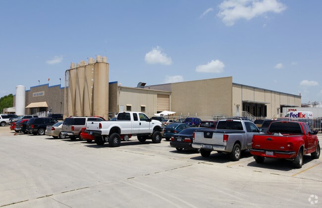

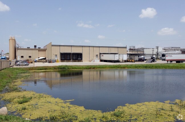
Property Detail
6905 Rigsby Ave E
San Antonio-New Braunfels, TX
CB 5127 P-4C(13.003A), P-5(13.054A), P-5B(14.085A) ABS 559
05127-000-0045
BEXAR
Lightindustrial
Texas
B and X Area of moderate flood hazard, usually the area between the limits of the 100-year and 500-year floods.
44
2024
40.14 AC
2025
South
141900
San Antonio
171,734 SF
NEARBY LISTINGS FOR SALE OR LEASE
DEMOGRAPHICS near 6905 Rigsby Ave E
1 mile
3 mile
5 mile
2025 Total Population
2,599
26,913
84,414
2030 Population
2,750
28,569
89,304
Pop Growth 2025-2030
+ 5.81%
+ 6.15%
+ 5.79%
Average Age
38
37
37
2025 Total Households
875
8,906
28,404
HH Growth 2025-2030
+ 5.83%
+ 6.28%
+ 5.88%
Median Household Inc
$91,051
$71,592
$60,431
Avg Household Size
3.00
3.00
2.90
2025 Avg HH Vehicles
2.00
2.00
2.00
Median Home Value
$285,848
$218,391
$208,678
Median Year Built
2002
1997
1985
Nearby Places
Map Layers
Map Styles
 Street
 Aerial
Layers
 Traffic
 Biking
Places
Listings with unknown addresses are not visible on the map
- Restaurants
- Banks
- Shops
- Fitness
- Groceries
PUBLIC TRANSPORTATION
COMMUTER RAIL
San Antonio Amtrak Station (Sunset Limited - Amtrak, Texas Eagle - Amtrak)
Drive
Walk
Distance
San Antonio Amtrak Station (Sunset Limited - Amtrak, Texas Eagle - Amtrak)
16 min
9.5 mi
AIRPORT
San Antonio International
Drive
Walk
Distance
San Antonio International
23 min
16.9 mi
Freight Ports
Calhoun Port
Drive
Walk
Distance
Calhoun Port
164 min
137.3 mi
Nearby Properties
Address
Land Use
TOTAL SIZE
Lot Size
Zoning
Address
Land Use
TOTAL SIZE
Lot Size
Zoning
545,980 SF
125.36 AC
Address
Land Use
TOTAL SIZE
Lot Size
Zoning
122,130 SF
541.40 AC
Address
Land Use
TOTAL SIZE
Lot Size
Zoning
434,029 SF
109.87 AC
Address
Land Use
TOTAL SIZE
Lot Size
Zoning
397,806 SF
15.08 AC
Address
Land Use
TOTAL SIZE
Lot Size
Zoning
690,500 SF
16.96 AC
Address
Land Use
TOTAL SIZE
Lot Size
Zoning
35.76 AC
Address
Land Use
TOTAL SIZE
Lot Size
Zoning
42.04 AC
Address
Land Use
TOTAL SIZE
Lot Size
Zoning
252,465 SF
37.40 AC
Address
Land Use
TOTAL SIZE
Lot Size
Zoning
41.63 AC
Address
Land Use
TOTAL SIZE
Lot Size
Zoning
33.77 AC
Address
Land Use
TOTAL SIZE
Lot Size
Zoning
4,920 SF
860.60 AC
Address
Land Use
TOTAL SIZE
Lot Size
Zoning
648 SF
392.83 AC
Address
Land Use
TOTAL SIZE
Lot Size
Zoning
14.14 AC
Address
Land Use
TOTAL SIZE
Lot Size
Zoning
18.35 AC
Address
Land Use
TOTAL SIZE
Lot Size
Zoning
17.47 AC
Address
Land Use
TOTAL SIZE
Lot Size
Zoning
141,955 SF
121.60 AC
Address
Land Use
TOTAL SIZE
Lot Size
Zoning
24.75 AC
Address
Land Use
TOTAL SIZE
Lot Size
Zoning
1,859 SF
60.40 AC
Address
Land Use
TOTAL SIZE
Lot Size
Zoning
296,542 SF
26.32 AC
Address
Land Use
TOTAL SIZE
Lot Size
Zoning
44,800 SF
61.44 AC
Address
Land Use
TOTAL SIZE
Lot Size
Zoning
221.68 AC
Address
Land Use
TOTAL SIZE
Lot Size
Zoning
204,166 SF
23.69 AC
Address
Land Use
TOTAL SIZE
Lot Size
Zoning
35,612 SF
7.15 AC
Address
Land Use
TOTAL SIZE
Lot Size
Zoning
2,497 SF
28 AC
Address
Land Use
TOTAL SIZE
Lot Size
Zoning
63,940 SF
6.09 AC
Address
Land Use
TOTAL SIZE
Lot Size
Zoning
120,984 SF
5 AC
Address
Land Use
TOTAL SIZE
Lot Size
Zoning
1,721 SF
48.03 AC
Address
Land Use
TOTAL SIZE
Lot Size
Zoning
61,636 SF
21.90 AC
Address
Land Use
TOTAL SIZE
Lot Size
Zoning
92,925 SF
10.64 AC
The World's #1 Commercial Real Estate Marketplace
Connect with us
© 2026 CoStar Group
The information above has been obtained from sources believed reliable. While we do not doubt its accuracy we have not verified it and make no guarantee, warranty or representation about it. It is your responsibility to independently confirm its accuracy and completeness. Any projections, opinions, assumptions, or estimates used are for example only and do not represent the current or future performance of the property. The value of this transaction to you depends on tax and other factors which should be evaluated by your tax, financial, and legal advisors. You and your advisors should conduct a careful, independent investigation of the property to determine to your satisfaction the suitability of the property for your needs.