Property Record
6905 Surfside Dr, Ventura, CA 93001


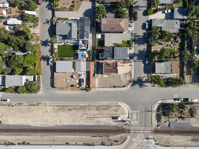

Property Detail
6905 Surfside Dr
060-0-075-240
MAP 12 PG 31 BLK H LOT 17,18
Storebuilding
Ventura
CC
California
B and X Area of moderate flood hazard, usually the area between the limits of the 100-year and 500-year floods.
0.12 AC
2025
Ventura
2025
Los Angeles
009500
Oxnard-Thousand Oaks-Ventura, CA
750 SF
NEARBY LISTINGS FOR SALE OR LEASE
-
-
View all Ventura listings for sale on LoopNet.com
DEMOGRAPHICS near 6905 Surfside Dr
1 mile
3 mile
5 mile
2025 Total Population
588
1,461
9,752
2030 Population
619
1,487
9,820
Pop Growth 2025-2030
+ 5.27%
+ 1.78%
+ 0.70%
Average Age
48
47
44
2025 Total Households
239
570
3,731
HH Growth 2025-2030
+ 5.44%
+ 1.93%
+ 0.80%
Median Household Inc
$86,842
$98,917
$97,688
Avg Household Size
2.30
2.40
2.50
2025 Avg HH Vehicles
2.00
2.00
2.00
Median Home Value
$916,666
$1,052,146
$1,058,098
Median Year Built
1972
1974
1971
Nearby Places
Map Layers
Map Styles
 Street
 Aerial
Layers
 Traffic
 Biking
Places
Listings with unknown addresses are not visible on the map
- Restaurants
- Banks
- Shops
- Fitness
- Groceries
PUBLIC TRANSPORTATION
COMMUTER RAIL
Drive
Walk
Distance
9 min
5.6 mi
AIRPORT
Santa Barbara Municipal
Drive
Walk
Distance
Santa Barbara Municipal
46 min
28.2 mi
Freight Ports
The Port of Hueneme
Drive
Walk
Distance
The Port of Hueneme
40 min
28.0 mi
SALE & LEASE HISTORY
LISTING DATE
SALE/LEASE

Nov 13, 2024
For Sale
Nearby Properties
Address
Land Use
TOTAL SIZE
Lot Size
Zoning
Address
Land Use
TOTAL SIZE
Lot Size
Zoning
Address
Land Use
TOTAL SIZE
Lot Size
Zoning
Address
Land Use
TOTAL SIZE
Lot Size
Zoning
19,602 SF
0.45 AC
Address
Land Use
TOTAL SIZE
Lot Size
Zoning
11.60 AC
AGI10
Address
Land Use
TOTAL SIZE
Lot Size
Zoning
1.28 AC
Address
Land Use
TOTAL SIZE
Lot Size
Zoning
3.77 AC
Address
Land Use
TOTAL SIZE
Lot Size
Zoning
10,999 SF
12.52 AC
AGI10
Address
Land Use
TOTAL SIZE
Lot Size
Zoning
5,171 SF
13.09 AC
3E1
Address
Land Use
TOTAL SIZE
Lot Size
Zoning
2.67 AC
Address
Land Use
TOTAL SIZE
Lot Size
Zoning
1.23 AC
Address
Land Use
TOTAL SIZE
Lot Size
Zoning
1.69 AC
Address
Land Use
TOTAL SIZE
Lot Size
Zoning
1.15 AC
Address
Land Use
TOTAL SIZE
Lot Size
Zoning
2.50 AC
AGI10
Address
Land Use
TOTAL SIZE
Lot Size
Zoning
962 SF
43.96 AC
OS-40
Address
Land Use
TOTAL SIZE
Lot Size
Zoning
2.25 AC
Address
Land Use
TOTAL SIZE
Lot Size
Zoning
Address
Land Use
TOTAL SIZE
Lot Size
Zoning
3,385 SF
34.42 AC
AGI10
Address
Land Use
TOTAL SIZE
Lot Size
Zoning
13,939 SF
0.32 AC
Address
Land Use
TOTAL SIZE
Lot Size
Zoning
9.25 AC
AGI10
Address
Land Use
TOTAL SIZE
Lot Size
Zoning
1.15 AC
Address
Land Use
TOTAL SIZE
Lot Size
Zoning
14,375 SF
0.33 AC
Address
Land Use
TOTAL SIZE
Lot Size
Zoning
0.28 AC
Address
Land Use
TOTAL SIZE
Lot Size
Zoning
500.32 AC
Address
Land Use
TOTAL SIZE
Lot Size
Zoning
0.95 AC
Address
Land Use
TOTAL SIZE
Lot Size
Zoning
89.80 AC
OS40AC
Address
Land Use
TOTAL SIZE
Lot Size
Zoning
1.25 AC
Address
Land Use
TOTAL SIZE
Lot Size
Zoning
75.73 AC
CM
Address
Land Use
TOTAL SIZE
Lot Size
Zoning
0.26 AC
Address
Land Use
TOTAL SIZE
Lot Size
Zoning
7.17 AC
AGI10
The World's #1 Commercial Real Estate Marketplace
Connect with us
© 2026 CoStar Group
The information above has been obtained from sources believed reliable. While we do not doubt its accuracy we have not verified it and make no guarantee, warranty or representation about it. It is your responsibility to independently confirm its accuracy and completeness. Any projections, opinions, assumptions, or estimates used are for example only and do not represent the current or future performance of the property. The value of this transaction to you depends on tax and other factors which should be evaluated by your tax, financial, and legal advisors. You and your advisors should conduct a careful, independent investigation of the property to determine to your satisfaction the suitability of the property for your needs.