Property Record
6906 Mccutchen Rd, Bakersfield, CA 93313
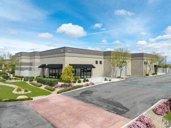


Property Detail
6906 Mccutchen Rd
539-100-03-00-5
17A CONDO 220109922
Commercialnec
KERN
M-1
California
2024
0.24 AC
2025
SW Outlying Kern County
003220
Bakersfield
10,399 SF
Bakersfield-Delano, CA
NEARBY LISTINGS FOR SALE OR LEASE
DEMOGRAPHICS near 6906 Mccutchen Rd
1 mile
3 mile
5 mile
2024 Total Population
7,623
82,816
215,496
2029 Population
7,714
82,793
215,580
Pop Growth 2024-2029
+ 1.19%
(0.03%)
+ 0.04%
Average Age
32
34
35
2024 Total Households
1,940
23,418
65,767
HH Growth 2024-2029
+ 1.29%
(0.11%)
(0.02%)
Median Household Inc
$97,860
$88,297
$70,682
Avg Household Size
3.80
3.50
3.20
2024 Avg HH Vehicles
2.00
2.00
2.00
Median Home Value
$361,075
$311,239
$289,230
Median Year Built
2010
1999
1987
Nearby Places
Map Layers
Map Styles
 Street
 Aerial
Transit
 Traffic
 Biking
Places
Listings with unknown addresses are not visible on the map
- Restaurants
- Banks
- Shops
- Fitness
- Groceries
PUBLIC TRANSPORTATION
AIRPORT
Meadows Field
Drive
Walk
Distance
Meadows Field
28 min
15.0 mi
Freight Ports
The Port of Hueneme
Drive
Walk
Distance
The Port of Hueneme
150 min
118.5 mi
SALE & LEASE HISTORY
LISTING DATE
SALE/LEASE

Feb 22, 2024
For Sale
Nearby Properties
Address
Land Use
TOTAL SIZE
Lot Size
Zoning
Address
Land Use
TOTAL SIZE
Lot Size
Zoning
587,976 SF
40.01 AC
M-2
Address
Land Use
TOTAL SIZE
Lot Size
Zoning
354,000 SF
20 AC
M2
Address
Land Use
TOTAL SIZE
Lot Size
Zoning
269,429 SF
12.71 AC
R-2
Address
Land Use
TOTAL SIZE
Lot Size
Zoning
37,760 SF
12.16 AC
R3
Address
Land Use
TOTAL SIZE
Lot Size
Zoning
223,557 SF
21.31 AC
PCD
Address
Land Use
TOTAL SIZE
Lot Size
Zoning
62,941 SF
8.79 AC
M-1
Address
Land Use
TOTAL SIZE
Lot Size
Zoning
88,988 SF
9.82 AC
C-2
Address
Land Use
TOTAL SIZE
Lot Size
Zoning
23,600 SF
8.17 AC
C2
Address
Land Use
TOTAL SIZE
Lot Size
Zoning
135,549 SF
12 AC
M1
Address
Land Use
TOTAL SIZE
Lot Size
Zoning
58,496 SF
7.32 AC
Address
Land Use
TOTAL SIZE
Lot Size
Zoning
69,414 SF
4.47 AC
M1
Address
Land Use
TOTAL SIZE
Lot Size
Zoning
12,008 SF
7.18 AC
Address
Land Use
TOTAL SIZE
Lot Size
Zoning
83,936 SF
4.39 AC
R-2
Address
Land Use
TOTAL SIZE
Lot Size
Zoning
41,507 SF
10.37 AC
C2
Address
Land Use
TOTAL SIZE
Lot Size
Zoning
10,073 SF
15.48 AC
PCD
Address
Land Use
TOTAL SIZE
Lot Size
Zoning
161,608 SF
10.70 AC
M2
Address
Land Use
TOTAL SIZE
Lot Size
Zoning
232,000 SF
15.74 AC
M-2
Address
Land Use
TOTAL SIZE
Lot Size
Zoning
113,910 SF
9.43 AC
M2
Address
Land Use
TOTAL SIZE
Lot Size
Zoning
149,777 SF
15.27 AC
C2
Address
Land Use
TOTAL SIZE
Lot Size
Zoning
7.62 AC
C2
Address
Land Use
TOTAL SIZE
Lot Size
Zoning
4.02 AC
C2
Address
Land Use
TOTAL SIZE
Lot Size
Zoning
140,235 SF
8 AC
M2
Address
Land Use
TOTAL SIZE
Lot Size
Zoning
150,000 SF
8.18 AC
M2
Address
Land Use
TOTAL SIZE
Lot Size
Zoning
10.37 AC
C2
Address
Land Use
TOTAL SIZE
Lot Size
Zoning
7.55 AC
Address
Land Use
TOTAL SIZE
Lot Size
Zoning
150,100 SF
6.78 AC
M-2
Address
Land Use
TOTAL SIZE
Lot Size
Zoning
1,014 SF
3.78 AC
PUD
Address
Land Use
TOTAL SIZE
Lot Size
Zoning
80,172 SF
14.14 AC
C-2
Address
Land Use
TOTAL SIZE
Lot Size
Zoning
28,587 SF
3.01 AC
M1
The World's #1 Commercial Real Estate Marketplace
Connect with us
© 2026 CoStar Group
The information above has been obtained from sources believed reliable. While we do not doubt its accuracy we have not verified it and make no guarantee, warranty or representation about it. It is your responsibility to independently confirm its accuracy and completeness. Any projections, opinions, assumptions, or estimates used are for example only and do not represent the current or future performance of the property. The value of this transaction to you depends on tax and other factors which should be evaluated by your tax, financial, and legal advisors. You and your advisors should conduct a careful, independent investigation of the property to determine to your satisfaction the suitability of the property for your needs.