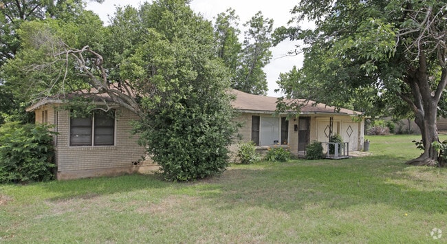
Property Record
6908 Boulevard 26, Richland Hills, TX 76180
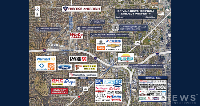
NEARBY LISTINGS FOR SALE OR LEASE
Property Detail
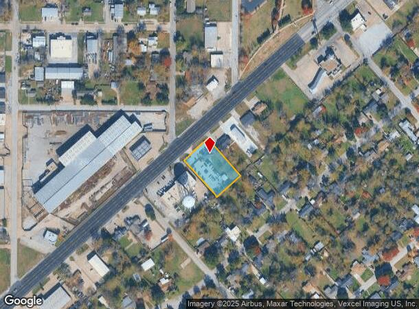
6908 Boulevard 26
Dallas-Fort Worth-Arlington, TX
Richland Hills Addition
04555074
RICHLAND HILLS ADDITION BLOCK 1 LOT 4 & 5
Commercialnec
Tarrant
X
Texas
48439C0205L
4,5
2024
0.88 AC
2025
East Northeast Ft Worth
113301
Dallas/Ft Worth
1,720 SF
DEMOGRAPHICS near 6908 Boulevard 26
1 Mile
3 Mile
5 Mile
2024 Total Population
11,065
93,602
272,952
2029 Population
11,605
98,622
287,819
Pop Growth 2024-2029
+ 4.88%
+ 5.36%
+ 5.45%
Average Age
40
38
38
2024 Total Households
4,171
35,788
102,577
HH Growth 2024-2029
+ 4.99%
+ 5.42%
+ 5.55%
Median Household Inc
$67,942
$62,419
$65,454
Avg Household Size
2.60
2.50
2.60
2024 Avg HH Vehicles
2.00
2.00
2.00
Median Home Value
$231,685
$228,414
$242,989
Median Year Built
1963
1976
1981
Nearby Places
Map Layers
Map Styles
 Street
 Aerial
- Restaurants
- Banks
- Shops
- Fitness
- Groceries
PUBLIC TRANSPORTATION
COMMUTER RAIL
Richland Hills (Trinity Railway Express - Dallas Area Rapid Transit (DART))
DRIVE
WALK
Distance
Richland Hills (Trinity Railway Express - Dallas Area Rapid Transit (DART))
5 min
2.8 mi
Trinity Lakes Station (TRINITY RAILWAY - Dallas Area Rapid Transit (DART))
DRIVE
WALK
Distance
Trinity Lakes Station (TRINITY RAILWAY - Dallas Area Rapid Transit (DART))
6 min
2.9 mi
AIRPORT
Dallas-Fort Worth International
DRIVE
WALK
Distance
Dallas-Fort Worth International
23 min
16.9 mi
Dallas Love Field
DRIVE
WALK
Distance
Dallas Love Field
34 min
25.5 mi
Freight Ports
Port of Shreveport
DRIVE
WALK
Distance
Port of Shreveport
244 min
224.8 mi
Nearby Properties
Address
Land Use
TOTAL SIZE
Lot Size
Zoning
Address
Land Use
TOTAL SIZE
Lot Size
Zoning
1,300,314 SF
40.15 AC
Address
Land Use
TOTAL SIZE
Lot Size
Zoning
381,000 SF
8.74 AC
Address
Land Use
TOTAL SIZE
Lot Size
Zoning
327,325 SF
16.87 AC
Address
Land Use
TOTAL SIZE
Lot Size
Zoning
174,596 SF
11.91 AC
Address
Land Use
TOTAL SIZE
Lot Size
Zoning
231,871 SF
17.08 AC
Address
Land Use
TOTAL SIZE
Lot Size
Zoning
318,602 SF
9.90 AC
Address
Land Use
TOTAL SIZE
Lot Size
Zoning
368,751 SF
19.97 AC
Address
Land Use
TOTAL SIZE
Lot Size
Zoning
293,972 SF
17.30 AC
Address
Land Use
TOTAL SIZE
Lot Size
Zoning
348,941 SF
22.25 AC
Address
Land Use
TOTAL SIZE
Lot Size
Zoning
237,551 SF
4.39 AC
Address
Land Use
TOTAL SIZE
Lot Size
Zoning
173,068 SF
15.55 AC
Address
Land Use
TOTAL SIZE
Lot Size
Zoning
241,064 SF
12.63 AC
Address
Land Use
TOTAL SIZE
Lot Size
Zoning
307,568 SF
13.13 AC
Address
Land Use
TOTAL SIZE
Lot Size
Zoning
232,295 SF
21.49 AC
Address
Land Use
TOTAL SIZE
Lot Size
Zoning
235,530 SF
13.21 AC
Address
Land Use
TOTAL SIZE
Lot Size
Zoning
194,625 SF
15.07 AC
Address
Land Use
TOTAL SIZE
Lot Size
Zoning
221,591 SF
14.50 AC
Address
Land Use
TOTAL SIZE
Lot Size
Zoning
220,650 SF
3.03 AC
Address
Land Use
TOTAL SIZE
Lot Size
Zoning
187,236 SF
9.85 AC
Address
Land Use
TOTAL SIZE
Lot Size
Zoning
176,242 SF
11.59 AC
Address
Land Use
TOTAL SIZE
Lot Size
Zoning
526,195 SF
40.84 AC
Address
Land Use
TOTAL SIZE
Lot Size
Zoning
195,678 SF
12.24 AC
Address
Land Use
TOTAL SIZE
Lot Size
Zoning
262,233 SF
16.13 AC
Address
Land Use
TOTAL SIZE
Lot Size
Zoning
132,145 SF
12.26 AC
Address
Land Use
TOTAL SIZE
Lot Size
Zoning
199,744 SF
9.99 AC
Address
Land Use
TOTAL SIZE
Lot Size
Zoning
191,235 SF
10.93 AC
Address
Land Use
TOTAL SIZE
Lot Size
Zoning
204,948 SF
23.93 AC
Address
Land Use
TOTAL SIZE
Lot Size
Zoning
350,000 SF
26.71 AC
Address
Land Use
TOTAL SIZE
Lot Size
Zoning
146,918 SF
3.31 AC
Address
Land Use
TOTAL SIZE
Lot Size
Zoning
141,276 SF
12.04 AC
The World's #1 Commercial Real Estate Marketplace
Connect with us
© 2025 CoStar Group
The information above has been obtained from sources believed reliable. While we do not doubt its accuracy we have not verified it and make no guarantee, warranty or representation about it. It is your responsibility to independently confirm its accuracy and completeness. Any projections, opinions, assumptions, or estimates used are for example only and do not represent the current or future performance of the property. The value of this transaction to you depends on tax and other factors which should be evaluated by your tax, financial, and legal advisors. You and your advisors should conduct a careful, independent investigation of the property to determine to your satisfaction the suitability of the property for your needs.