Property Record
69096 Powell Rd, Armada, MI 48005

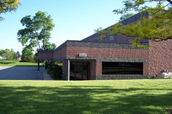
Property Detail
69096 Powell Rd
30-02-31-356-004
30-02-31-356-004 T5N, R13E UNIT 4 IRONWOOD CORPORATE PARK MCCP NO 640 NOW KNOWN AS EAST POND CORPORATE PARK ANNEXED INTO VLG
Lightindustrial
MACOMB
MI
Michigan
2025
1.96 AC
2025
St Clair & Lapeer Counties
212000
Detroit
30,790 SF
Detroit-Warren-Dearborn, MI
NEARBY LISTINGS FOR SALE OR LEASE
DEMOGRAPHICS near 69096 Powell Rd
1 mile
3 mile
5 mile
2025 Total Population
112
11,134
22,072
2030 Population
114
11,336
22,501
Pop Growth 2025-2030
+ 1.79%
+ 1.81%
+ 1.94%
Average Age
44
43
43
2025 Total Households
42
4,273
8,173
HH Growth 2025-2030
+ 2.38%
+ 1.80%
+ 1.91%
Median Household Inc
$108,333
$91,553
$103,307
Avg Household Size
2.60
2.50
2.70
2025 Avg HH Vehicles
3.00
2.00
2.00
Median Home Value
$416,667
$348,582
$398,017
Median Year Built
1977
1980
1986
Nearby Places
Map Layers
Map Styles
 Street
 Aerial
Layers
 Traffic
 Biking
Places
Listings with unknown addresses are not visible on the map
- Restaurants
- Banks
- Shops
- Fitness
- Groceries
SALE & LEASE HISTORY
LISTING DATE
SALE/LEASE

Sep 25, 2016
For Lease
Sep 24, 2016
For Sale
May 03, 2017
For Sale
Jun 09, 2017
For Sale
Nearby Properties
Address
Land Use
TOTAL SIZE
Lot Size
Zoning
Address
Land Use
TOTAL SIZE
Lot Size
Zoning
1,937,172 SF
252.22 AC
IND VLG CK
Address
Land Use
TOTAL SIZE
Lot Size
Zoning
81,488 SF
14.54 AC
VILLAGE
Address
Land Use
TOTAL SIZE
Lot Size
Zoning
142,894 SF
IFT
Address
Land Use
TOTAL SIZE
Lot Size
Zoning
60,995 SF
19.75 AC
IND
Address
Land Use
TOTAL SIZE
Lot Size
Zoning
77,006 SF
12.52 AC
M-1
Address
Land Use
TOTAL SIZE
Lot Size
Zoning
49,800 SF
2.81 AC
IND VLG CK
Address
Land Use
TOTAL SIZE
Lot Size
Zoning
58,233 SF
17.47 AC
IND
Address
Land Use
TOTAL SIZE
Lot Size
Zoning
Address
Land Use
TOTAL SIZE
Lot Size
Zoning
131,594 SF
4.90 AC
IND VLG CK
Address
Land Use
TOTAL SIZE
Lot Size
Zoning
75,808 SF
Address
Land Use
TOTAL SIZE
Lot Size
Zoning
79,775 SF
4.71 AC
M-1
Address
Land Use
TOTAL SIZE
Lot Size
Zoning
74,013 SF
4.41 AC
VERIFY
Address
Land Use
TOTAL SIZE
Lot Size
Zoning
123,624 SF
13.05 AC
VILLAGE
Address
Land Use
TOTAL SIZE
Lot Size
Zoning
35,935 SF
5.57 AC
GC
Address
Land Use
TOTAL SIZE
Lot Size
Zoning
80,000 SF
IFT
Address
Land Use
TOTAL SIZE
Lot Size
Zoning
35,798 SF
84.03 AC
A1
Address
Land Use
TOTAL SIZE
Lot Size
Zoning
106,097 SF
6.21 AC
IND VLG CK
Address
Land Use
TOTAL SIZE
Lot Size
Zoning
127,018 SF
4.50 AC
IND VLG CK
Address
Land Use
TOTAL SIZE
Lot Size
Zoning
71,874 SF
3.90 AC
IND VLG CK
Address
Land Use
TOTAL SIZE
Lot Size
Zoning
94,422 SF
24.90 AC
MI
Address
Land Use
TOTAL SIZE
Lot Size
Zoning
53,525 SF
IFT
Address
Land Use
TOTAL SIZE
Lot Size
Zoning
24,660 SF
2.65 AC
GC
Address
Land Use
TOTAL SIZE
Lot Size
Zoning
46,548 SF
40.49 AC
M-1
Address
Land Use
TOTAL SIZE
Lot Size
Zoning
76,438 SF
11.87 AC
C-2
Address
Land Use
TOTAL SIZE
Lot Size
Zoning
45,089 SF
13.70 AC
MI
Address
Land Use
TOTAL SIZE
Lot Size
Zoning
58,636 SF
4.08 AC
IND VLG CK
Address
Land Use
TOTAL SIZE
Lot Size
Zoning
40,800 SF
Address
Land Use
TOTAL SIZE
Lot Size
Zoning
72,025 SF
7.74 AC
GC
Address
Land Use
TOTAL SIZE
Lot Size
Zoning
46,181 SF
2.61 AC
IND VLG CK
Address
Land Use
TOTAL SIZE
Lot Size
Zoning
72,104 SF
8.37 AC
GC
The World's #1 Commercial Real Estate Marketplace
Connect with us
© 2026 CoStar Group
The information above has been obtained from sources believed reliable. While we do not doubt its accuracy we have not verified it and make no guarantee, warranty or representation about it. It is your responsibility to independently confirm its accuracy and completeness. Any projections, opinions, assumptions, or estimates used are for example only and do not represent the current or future performance of the property. The value of this transaction to you depends on tax and other factors which should be evaluated by your tax, financial, and legal advisors. You and your advisors should conduct a careful, independent investigation of the property to determine to your satisfaction the suitability of the property for your needs.