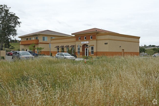
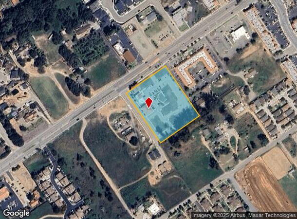
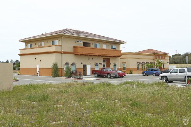
Property Record
691 W Tefft St, Nipomo, CA 93444

NEARBY LISTINGS FOR SALE OR LEASE
Property Detail
691 W Tefft St
San Luis Obispo-Paso Robles-Arroyo Grande, CA
Hc Wards
092-577-008
RHO NIPOMO PTN LT 5
Medicalbuilding
San Luis Obispo
X
California
06079C1636G
5
2024
2.83 AC
2025
South 101 Corridor
012404
San Luis Obispo/Paso Robles
11,245 SF
DEMOGRAPHICS near 691 W Tefft St
1 Mile
3 Mile
5 Mile
2024 Total Population
8,812
17,234
34,705
2029 Population
8,638
16,813
34,018
Pop Growth 2024-2029
(1.97%)
(2.44%)
(1.98%)
Average Age
38
41
41
2024 Total Households
2,907
5,849
11,045
HH Growth 2024-2029
(2.17%)
(2.63%)
(2.13%)
Median Household Inc
$74,584
$89,082
$91,782
Avg Household Size
2.90
2.80
3.00
2024 Avg HH Vehicles
2.00
3.00
2.00
Median Home Value
$617,647
$697,268
$630,863
Median Year Built
1988
1987
1989
Nearby Places
Map Layers
Map Styles
 Street
 Aerial
- Restaurants
- Banks
- Shops
- Fitness
- Groceries
PUBLIC TRANSPORTATION
COMMUTER RAIL
Guadalupe Amtrak Station (Pacific Surfliner - Amtrak)
DRIVE
WALK
Distance
Guadalupe Amtrak Station (Pacific Surfliner - Amtrak)
16 min
9.2 mi
AIRPORT
San Luis County Regional
DRIVE
WALK
Distance
San Luis County Regional
29 min
18.5 mi
Freight Ports
The Port of Hueneme
DRIVE
WALK
Distance
The Port of Hueneme
143 min
109.6 mi
Nearby Properties
Address
Land Use
TOTAL SIZE
Lot Size
Zoning
Address
Land Use
TOTAL SIZE
Lot Size
Zoning
81,330 SF
4.15 AC
CR
Address
Land Use
TOTAL SIZE
Lot Size
Zoning
2.61 AC
RMF
Address
Land Use
TOTAL SIZE
Lot Size
Zoning
4.50 AC
RMF
Address
Land Use
TOTAL SIZE
Lot Size
Zoning
728 SF
4.50 AC
PF
Address
Land Use
TOTAL SIZE
Lot Size
Zoning
3.11 AC
RMF
Address
Land Use
TOTAL SIZE
Lot Size
Zoning
34.30 AC
RR
Address
Land Use
TOTAL SIZE
Lot Size
Zoning
4 AC
RMF
Address
Land Use
TOTAL SIZE
Lot Size
Zoning
Address
Land Use
TOTAL SIZE
Lot Size
Zoning
276.22 AC
Address
Land Use
TOTAL SIZE
Lot Size
Zoning
41,631 SF
4.45 AC
CR
Address
Land Use
TOTAL SIZE
Lot Size
Zoning
20,118 SF
2.11 AC
CR
Address
Land Use
TOTAL SIZE
Lot Size
Zoning
18,065 SF
1.01 AC
CR
Address
Land Use
TOTAL SIZE
Lot Size
Zoning
39,348 SF
3.53 AC
CS
Address
Land Use
TOTAL SIZE
Lot Size
Zoning
39.09 AC
RR
Address
Land Use
TOTAL SIZE
Lot Size
Zoning
57,000 SF
3.16 AC
CS
Address
Land Use
TOTAL SIZE
Lot Size
Zoning
16,140 SF
1.36 AC
CS
Address
Land Use
TOTAL SIZE
Lot Size
Zoning
16,640 SF
1.92 AC
CR
Address
Land Use
TOTAL SIZE
Lot Size
Zoning
198 AC
AG
Address
Land Use
TOTAL SIZE
Lot Size
Zoning
1.26 AC
RMF
Address
Land Use
TOTAL SIZE
Lot Size
Zoning
3,330 SF
142 AC
AG
Address
Land Use
TOTAL SIZE
Lot Size
Zoning
35,680 SF
3.86 AC
CR
Address
Land Use
TOTAL SIZE
Lot Size
Zoning
5.22 AC
CR
Address
Land Use
TOTAL SIZE
Lot Size
Zoning
20,652 SF
1.91 AC
CR
Address
Land Use
TOTAL SIZE
Lot Size
Zoning
24,057 SF
1.85 AC
CS
Address
Land Use
TOTAL SIZE
Lot Size
Zoning
4,898 SF
210 AC
AG
Address
Land Use
TOTAL SIZE
Lot Size
Zoning
16.02 AC
CS
Address
Land Use
TOTAL SIZE
Lot Size
Zoning
21,400 SF
2 AC
CR
Address
Land Use
TOTAL SIZE
Lot Size
Zoning
22,082 SF
1.33 AC
RMF
Address
Land Use
TOTAL SIZE
Lot Size
Zoning
2,049 SF
114 AC
AG
Address
Land Use
TOTAL SIZE
Lot Size
Zoning
124.60 AC
AG
The World's #1 Commercial Real Estate Marketplace
Connect with us
© 2025 CoStar Group
The information above has been obtained from sources believed reliable. While we do not doubt its accuracy we have not verified it and make no guarantee, warranty or representation about it. It is your responsibility to independently confirm its accuracy and completeness. Any projections, opinions, assumptions, or estimates used are for example only and do not represent the current or future performance of the property. The value of this transaction to you depends on tax and other factors which should be evaluated by your tax, financial, and legal advisors. You and your advisors should conduct a careful, independent investigation of the property to determine to your satisfaction the suitability of the property for your needs.