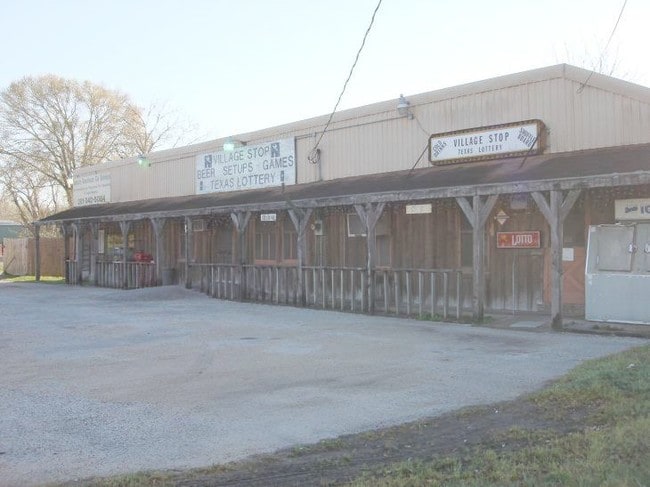
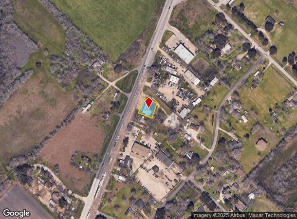
Property Record
6911 Highway 36 S, Rosenberg, TX 77471
NEARBY LISTINGS FOR SALE OR LEASE
Property Detail
6911 Highway 36 S
Houston-Pasadena-The Woodlands, TX
C B Stewart
0090-00-000-0412-901
0090 C B STEWART, TRACT 41 (PT), ACRES 0.50
Commercialnec
Fort Bend
X
Texas
48157C0400M
41
2024
0.50 AC
2025
Far New Territory
675501
Houston
2,673 SF
DEMOGRAPHICS near 6911 Highway 36 S
1 Mile
3 Mile
5 Mile
2024 Total Population
2,994
16,884
51,549
2029 Population
3,685
20,619
62,556
Pop Growth 2024-2029
+ 23.08%
+ 22.12%
+ 21.35%
Average Age
35
35
36
2024 Total Households
862
5,188
16,706
HH Growth 2024-2029
+ 23.67%
+ 22.69%
+ 21.88%
Median Household Inc
$80,278
$70,258
$67,217
Avg Household Size
3.20
3.20
3.00
2024 Avg HH Vehicles
2.00
2.00
2.00
Median Home Value
$246,205
$222,970
$224,003
Median Year Built
2010
2010
2003
Nearby Places
Map Layers
Map Styles
 Street
 Aerial
- Restaurants
- Banks
- Shops
- Fitness
- Groceries
PUBLIC TRANSPORTATION
AIRPORT
William P Hobby
DRIVE
WALK
Distance
William P Hobby
58 min
41.4 mi
Nearby Properties
Address
Land Use
TOTAL SIZE
Lot Size
Zoning
Address
Land Use
TOTAL SIZE
Lot Size
Zoning
17.73 AC
Address
Land Use
TOTAL SIZE
Lot Size
Zoning
98,691 SF
29.37 AC
Address
Land Use
TOTAL SIZE
Lot Size
Zoning
Address
Land Use
TOTAL SIZE
Lot Size
Zoning
25.69 AC
Address
Land Use
TOTAL SIZE
Lot Size
Zoning
133,826 SF
11.60 AC
Address
Land Use
TOTAL SIZE
Lot Size
Zoning
30.46 AC
S
Address
Land Use
TOTAL SIZE
Lot Size
Zoning
72,400 SF
10 AC
Address
Land Use
TOTAL SIZE
Lot Size
Zoning
21,867 SF
70.17 AC
Address
Land Use
TOTAL SIZE
Lot Size
Zoning
109.89 AC
YQ
Address
Land Use
TOTAL SIZE
Lot Size
Zoning
288.44 AC
Address
Land Use
TOTAL SIZE
Lot Size
Zoning
1,965 SF
170.82 AC
SOYK
Address
Land Use
TOTAL SIZE
Lot Size
Zoning
134.60 AC
Address
Land Use
TOTAL SIZE
Lot Size
Zoning
111.59 AC
QOY
Address
Land Use
TOTAL SIZE
Lot Size
Zoning
Address
Land Use
TOTAL SIZE
Lot Size
Zoning
864 SF
80.11 AC
QYSN
Address
Land Use
TOTAL SIZE
Lot Size
Zoning
10 AC
S
Address
Land Use
TOTAL SIZE
Lot Size
Zoning
50,000 SF
13 AC
Address
Land Use
TOTAL SIZE
Lot Size
Zoning
49,725 SF
3.57 AC
Address
Land Use
TOTAL SIZE
Lot Size
Zoning
25,200 SF
23.20 AC
Address
Land Use
TOTAL SIZE
Lot Size
Zoning
68.37 AC
QY
Address
Land Use
TOTAL SIZE
Lot Size
Zoning
55.45 AC
Address
Land Use
TOTAL SIZE
Lot Size
Zoning
15.19 AC
Address
Land Use
TOTAL SIZE
Lot Size
Zoning
2.53 AC
Address
Land Use
TOTAL SIZE
Lot Size
Zoning
4.82 AC
Address
Land Use
TOTAL SIZE
Lot Size
Zoning
2.06 AC
Address
Land Use
TOTAL SIZE
Lot Size
Zoning
19.60 AC
Address
Land Use
TOTAL SIZE
Lot Size
Zoning
55,325 SF
2.50 AC
SY
Address
Land Use
TOTAL SIZE
Lot Size
Zoning
45.10 AC
STR
Address
Land Use
TOTAL SIZE
Lot Size
Zoning
1,076 SF
80.30 AC
QY
Address
Land Use
TOTAL SIZE
Lot Size
Zoning
57.02 AC
The World's #1 Commercial Real Estate Marketplace
Connect with us
© 2026 CoStar Group
The information above has been obtained from sources believed reliable. While we do not doubt its accuracy we have not verified it and make no guarantee, warranty or representation about it. It is your responsibility to independently confirm its accuracy and completeness. Any projections, opinions, assumptions, or estimates used are for example only and do not represent the current or future performance of the property. The value of this transaction to you depends on tax and other factors which should be evaluated by your tax, financial, and legal advisors. You and your advisors should conduct a careful, independent investigation of the property to determine to your satisfaction the suitability of the property for your needs.