Property Record
6911 State Highway 66, Tulsa, OK 74131
NEARBY LISTINGS FOR SALE OR LEASE
-
-
View all Tulsa listings for sale on LoopNet.com
Property Detail
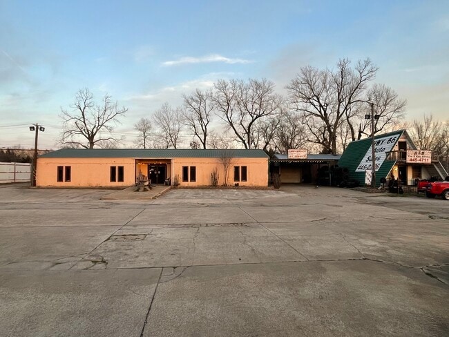
6911 State Highway 66
0000-06-018-012-0-013-01
6-18-12 BEG AT SW COR E SE E200.33 NELY 105 7.27 TO A POB NELY 105.8 N64'48 00 W201.51 S25'48 W97.2 S62'35 54 E182.2 POB DEAN
Officebuilding
Creek
X
Oklahoma
40143C0329K
0.44 AC
2024
Creek County
2025
Tulsa
020101
Tulsa, OK
2,740 SF
DEMOGRAPHICS near 6911 State Highway 66
1 Mile
3 Mile
5 Mile
2024 Total Population
1,096
16,902
58,451
2029 Population
1,132
17,546
60,590
Pop Growth 2024-2029
+ 3.28%
+ 3.81%
+ 3.66%
Average Age
40
40
39
2024 Total Households
396
6,438
23,003
HH Growth 2024-2029
+ 3.28%
+ 3.76%
+ 3.61%
Median Household Inc
$50,238
$61,544
$62,080
Avg Household Size
2.50
2.50
2.50
2024 Avg HH Vehicles
2.00
2.00
2.00
Median Home Value
$139,285
$186,552
$176,575
Median Year Built
1981
1983
1981
Nearby Places
Map Layers
Map Styles
 Street
 Aerial
- Restaurants
- Banks
- Shops
- Fitness
- Groceries
PUBLIC TRANSPORTATION
AIRPORT
Tulsa International
DRIVE
WALK
Distance
Tulsa International
24 min
17.1 mi
Freight Ports
Tulsa Port Of Catoosa
DRIVE
WALK
Distance
Tulsa Port Of Catoosa
34 min
26.4 mi
SALE & LEASE HISTORY
LISTING DATE
SALE/LEASE

Mar 30, 2022
For Sale
Nearby Properties
Address
Land Use
TOTAL SIZE
Lot Size
Zoning
Address
Land Use
TOTAL SIZE
Lot Size
Zoning
1,134,776 SF
35.85 AC
CN
Address
Land Use
TOTAL SIZE
Lot Size
Zoning
119,056 SF
28.06 AC
CM
Address
Land Use
TOTAL SIZE
Lot Size
Zoning
143,520 SF
25.14 AC
IM
Address
Land Use
TOTAL SIZE
Lot Size
Zoning
47,670 SF
10.05 AC
RS
Address
Land Use
TOTAL SIZE
Lot Size
Zoning
22,078 SF
5.08 AC
CS
Address
Land Use
TOTAL SIZE
Lot Size
Zoning
23,269 SF
263.40 AC
NCU
Address
Land Use
TOTAL SIZE
Lot Size
Zoning
251,601 SF
16.75 AC
RM1
Address
Land Use
TOTAL SIZE
Lot Size
Zoning
117,372 SF
11.87 AC
CN
Address
Land Use
TOTAL SIZE
Lot Size
Zoning
20,771 SF
1.11 AC
RS3
Address
Land Use
TOTAL SIZE
Lot Size
Zoning
370,891 SF
26.43 AC
IM
Address
Land Use
TOTAL SIZE
Lot Size
Zoning
16,000 SF
5 AC
CS
Address
Land Use
TOTAL SIZE
Lot Size
Zoning
38,940 SF
16.24 AC
Address
Land Use
TOTAL SIZE
Lot Size
Zoning
2,152 SF
8.88 AC
Address
Land Use
TOTAL SIZE
Lot Size
Zoning
31,600 SF
13.46 AC
Address
Land Use
TOTAL SIZE
Lot Size
Zoning
25,685 SF
5.04 AC
Address
Land Use
TOTAL SIZE
Lot Size
Zoning
40,069 SF
4.22 AC
RM0
Address
Land Use
TOTAL SIZE
Lot Size
Zoning
19,188 SF
3.87 AC
RS3
Address
Land Use
TOTAL SIZE
Lot Size
Zoning
41,444 SF
4.71 AC
CG
Address
Land Use
TOTAL SIZE
Lot Size
Zoning
4,785 SF
7.34 AC
Address
Land Use
TOTAL SIZE
Lot Size
Zoning
23,100 SF
30 AC
IM
Address
Land Use
TOTAL SIZE
Lot Size
Zoning
9,282 SF
4.83 AC
Address
Land Use
TOTAL SIZE
Lot Size
Zoning
82,140 SF
10.61 AC
IL
Address
Land Use
TOTAL SIZE
Lot Size
Zoning
52,050 SF
16.29 AC
Address
Land Use
TOTAL SIZE
Lot Size
Zoning
15,230 SF
8.65 AC
Address
Land Use
TOTAL SIZE
Lot Size
Zoning
1 SF
24.88 AC
IL
Address
Land Use
TOTAL SIZE
Lot Size
Zoning
66,975 SF
7.80 AC
Address
Land Use
TOTAL SIZE
Lot Size
Zoning
172,256 SF
10.76 AC
Address
Land Use
TOTAL SIZE
Lot Size
Zoning
20,625 SF
13.39 AC
TM
Address
Land Use
TOTAL SIZE
Lot Size
Zoning
22,721 SF
13.12 AC
The World's #1 Commercial Real Estate Marketplace
Connect with us
© 2026 CoStar Group
The information above has been obtained from sources believed reliable. While we do not doubt its accuracy we have not verified it and make no guarantee, warranty or representation about it. It is your responsibility to independently confirm its accuracy and completeness. Any projections, opinions, assumptions, or estimates used are for example only and do not represent the current or future performance of the property. The value of this transaction to you depends on tax and other factors which should be evaluated by your tax, financial, and legal advisors. You and your advisors should conduct a careful, independent investigation of the property to determine to your satisfaction the suitability of the property for your needs.